ABSTRACT
Since the outbreak of African Swine Fever in Mainland China in 2018, Taiwan’s Ministry of Agriculture (MOA) has revised regulations related to animal transport. It is now mandated that vehicles transporting live pigs, carcasses, internal organs, and branches must be equipped with GPS (Global Positioning System) to prevent the spread of African Swine Fever into Taiwan's livestock farms. Currently, around 3,000 transport vehicles are equipped with GPS, and the MOA's Department of Information Technology (IT Department) oversees these vehicles, receiving GPS data points every 30 seconds via the "Livestock and Carcass Transport Vehicle Trajectory Check Management System." However, due to the variety of GPS device manufacturers, signal quality is inconsistent. Some transport vehicles experience issues such as signal drift, jumps, or loss during their journeys. Additionally, because most meat markets are in areas with convenient transportation access, transport vehicles often pass by without stopping. This has led some markets to erroneously use GPS trajectory records as the sole criterion for determining entry, resulting in potential misjudgments. To enhance the efficiency of GPS signal verification and broaden its use in epidemic prevention, the MOA installed surveillance cameras at the entrances of 28 meat markets and processing plants nationwide in 2022. These cameras are installed with license plate recognition technology to analyze streaming images for license plate information and include artificial intelligence (AI) capabilities to recognize the load category of entering transport vehicles. When a transport vehicle enters a venue, the system immediately detects the event and compares it with the GPS signal. This process identifies transport vehicles that are required to have GPS but do not, and promptly alerts front-line quarantine personnel to inspect the vehicle using the app named "Livestock Transport Vehicle Check."
Keywords: African Swine Fever Prevention, object detection, ArcGIS, GeoEvent, GPS, YOLOv7
INTRODUCTION
Since the outbreak of African swine fever in mainland China in 2018, the Ministry of Agriculture (MOA) of Taiwan has amended and issued the "Animal Transportation Management Measures" and "Slaughter Operation Guidelines" to prevent the epidemic from invading Taiwan’s domestic farms. Vehicles transporting live pigs, carcasses, viscera, and cuttings are now mandated to install a Global Positioning System (GPS). The "Epidemic Prevention Measures Prohibiting the Transport of Designated Livestock to Meat Markets or Slaughterhouses" was also issued, stipulating that livestock intended for slaughter on the market should submit a livestock health declaration following regulation to control the source and ensure that the livestock is not infected with African swine fever. To manage livestock transport vehicles more effectively, developing a real-time system to monitor these vehicles has become important for the MOA.
Inspired by Taiwan's 1997 foot-and-mouth disease prevention experience, the MOA has launched an information system development project to simulate effective prevention and control measures for African swine fever outbreaks. This project involves developing a system that can instantly identify illegal vehicles transporting pigs to slaughterhouses at the entrances and exits of meat markets. Information about these illegal vehicles is then communicated to front-line quarantine personnel, prioritizing the inspection of whether these vehicles have installed GPS systems or if there are any transmission anomalies in the market identification system.
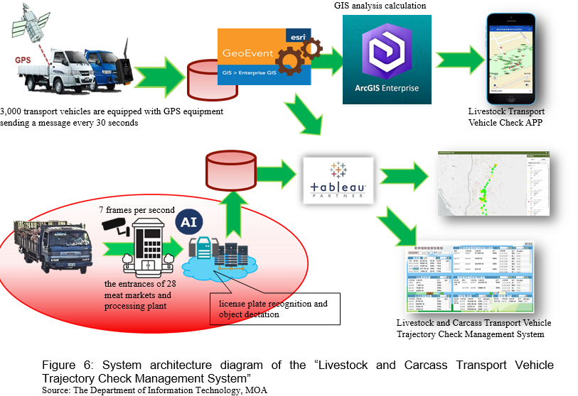
The MOA's IT Department uses license plates and time stamps to connect data from various sources in this system, including the vehicle's registration data with a GPS device, license plate data recognized by the meat market surveillance camera, and the AI-powered load category recognition results. The system integrated license plate data, entry and exit times, GPS trajectory to the previous location, load category, and vehicle registration data. It then transmitted this information to an app named "Livestock Transport Vehicle Check," prompting front-line quarantine personnel to inspect suspicious vehicles immediately upon their arrival. The following paragraphs will introduce how this system operates.
DATA PROCESSING AND FUNCTION DEVELOPMENT
Taiwan has approximately 3,000 transport vehicles equipped with GPS devices, transmitting 8 million data points daily. The MOA's IT Department utilizes ArcGIS Enterprise and ArcGIS GeoEvent Server to maintain and update the vehicles' real-time trajectory records. The ArcGIS GeoEvent Server's filtering and processing functionalities enable the identification and removal of erroneous trajectory data exhibiting large positioning offsets or conforming to specified error patterns. Following normalization, the original data is stored within the database. To effectively utilize this data, the MOA's IT Department has developed several critical systems, included "Real-Time Geofence Entry Event Recordation," "Real-Time License Plate Recognition Service," and " Real-time Entry Event Service for Transport Vehicles." We will discuss these services in detail below.
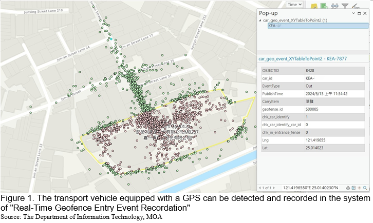
The system of “Real-Time Geofence Entry Event Recordation”
Utilizing the filter and processor functions provided by ArcGIS GeoEvent Server, the normalized data is imported into the geofence maintained by the MOA’s IT Department. Approximately 9,500 entries cover pig and cattle farms, rendering plants, and meat markets. Each transport vehicle equipped with a GPS represents a GPS point. When a GPS point enters a predefined geofence, it triggers an event with attribute data. Subsequently, the data on transport vehicles' entry and exit conditions in 28 venues are analyzed. Direction, speed, and buffer analyses are performed using the information from GPS points before and after they enter the geofence. Additionally, the IT Department of the MOA modifies the geofence range, which reduces the impact of varying quality among different GPS devices and minimizes errors or omissions when detection venues are adjacent to major intersections.
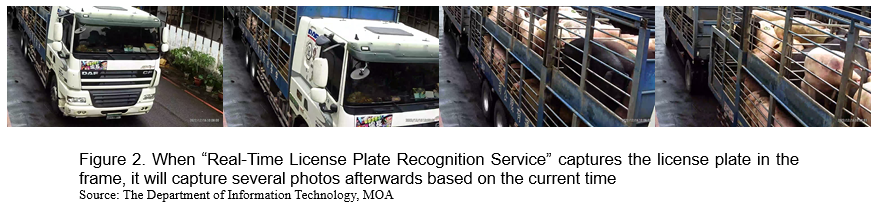
The system of “Real-Time License Plate Recognition Service”
The MOA’s IT Department has further developed the system of “Real-Time License Plate Recognition Service.” In 28 venues, the license plate recognition system records the time when the license plate is captured in the streaming video, and each cuts a picture within 5 seconds afterwards, which is used as a cluster and defined as a vehicle entry event. Through one event, we can get the truck's license plate number and several subsequent pictures containing the load category of the truck bed.
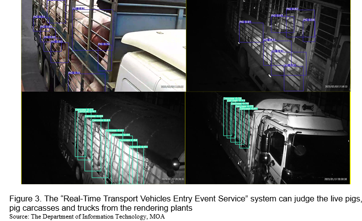
The system of “Real-Time Transport Vehicles Entry Event Service”
The MOA's IT Department uses the event photos collected from 28 venues as training data, uses YOLOv7 as the framework, and conducts object detection model training. The main recognition category is live pigs, followed by pig carcasses and trucks from the rendering plants. The final recognition result of each event is logically judged by the quantity and confidence value of the model interpretation results selected in each photo. The unique interpretation result of the event is integrated, and the result is written into the system named "Real-Time Transport Vehicles Entry Event Service."
Integrated application of three systems
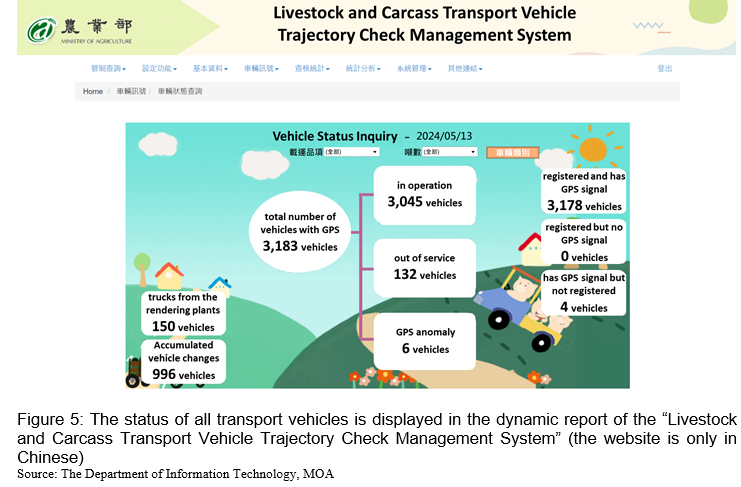
The IT Department at the MOA has efficiently processed extensive daily GPS data from each transport vehicle using ArcGIS Enterprise and Tableau tools. This automation ensures the continuous operation and stability of GPS systems in all transport vehicles, meeting 24-hour epidemic prevention requirements with minimal manpower. The analyzed data is converted into two distinct event services: "License Plate Recognition Entry Real-time Event Service for Vehicles" and "Geofence Entry Real-time Event Service for Transport Vehicles." By using the license plate number as a key identifier, an automated program cross-references the vehicle registration data with the GPS system installation details. If a GPS signal mismatch is detected, a dynamic GPS device failure report is generated in the "Livestock and Carcass Transport Vehicle Trajectory Check Management System." Additionally, Short Message Service (SMS) and email notifications are automatically sent to the vehicle owner and the GPS device manufacturer, significantly reducing the repair time for the GPS systems.
In the 28 venues equipped with surveillance cameras, the “Real-Time Geofence Entry Event Recordation” provides detailed information about the license plates and entry/exit times of transport vehicles daily. By cross-referencing this data with the “Real-Time License Plate Recognition Service” system during the same time periods, the missed recognition rate for each surveillance camera can be calculated. The results are then compiled into a report within the “Livestock and Carcass Transport Vehicle Trajectory Check Management System.” This report allows system management personnel to effectively monitor the performance of the surveillance equipment at each venue.
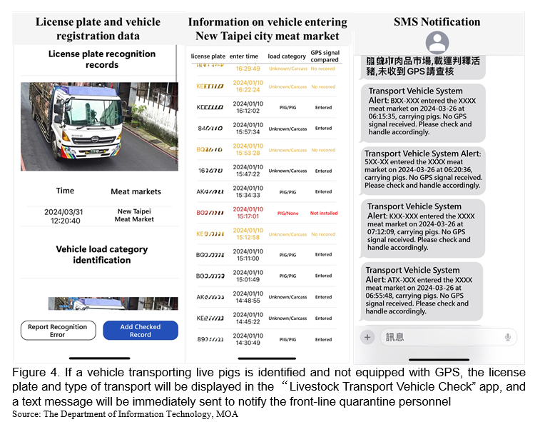
Currently, in addition to detecting GPS device failures and monitoring the condition of surveillance equipment across 28 venues, the system has an even more powerful feature: actively combating illegal transport vehicles. The “Real-Time License Plate Recognition Service” uses an object detection model to determine the load category of transport vehicles entering a venue. This data is then linked with vehicle license plates and their trajectory information through the “Real-Time Transport Vehicles Entry Event Service” and displayed on the “Livestock Transport Vehicle Check” app developed by MOA's IT Department.
If live pigs are detected and the vehicle's license plate is not registered in the system database, the app will immediately show the license plate, load category, and registered load category of the entering vehicle. A mobile text message is also sent to notify front-line epidemic prevention personnel at the venue, enabling proactive enforcement against vehicles that have not installed GPS devices and addressing potential gaps in epidemic prevention.
Furthermore, if the recognized vehicle's license plate is registered in the database, the app will display its trajectory and registration data. This allows front-line epidemic prevention personnel to compare it with the livestock health declaration information, which includes details such as livestock or breeding registration certificates, breeding species, farm number, and the animal owner's or manager's contact information. This process helps prevent livestock farms from lending their registration certificates to illegal operations and enhances the effectiveness of source control.
CONCLUSIONS
The MOA of Taiwan has undertaken a comprehensive approach to enhance its epidemic prevention measures in response to the African swine fever outbreak in Mainland China. By mandating GPS installation on transport vehicles and leveraging advanced technologies such as ArcGIS Enterprise, Tableau, and AI-powered systems, the MOA has significantly improved its capability to monitor and manage livestock transportation. The integration of real-time GPS data with surveillance cameras' license plate recognition and vehicle load category identification has created a robust framework for identifying and addressing anomalies, signal failures, and potential illegal activities.
The multi-faceted system not only ensures the continuous and stable operation of GPS across approximately 3,000 transport vehicles but also facilitates immediate action in the event of discrepancies. Automated notifications and dynamic reporting streamline the response process, reducing downtime for GPS repairs and enhancing the overall efficiency of epidemic prevention operations. The system fills critical gaps in epidemic prevention and source control by proactively detecting and notifying authorities about unregistered or non-compliant vehicles.
As a result, establishing this system and developing related services can effectively control the movements of all transport vehicles, livestock farms, and meat markets across Taiwan, establish a visual epidemic prevention map, and reduce the cost of inspection and monitoring. It effectively protects the current value of Taiwan’s pig farming industry, which is close to 80 billion a year, and the overall value of the industry chain exceeds 150 billion.
REFERENCES
Alexey Bochkovskiy, & Chien-Yao Wang, &Hong-Yuan Mark Liao (2020). YOLOv4: Optimal Speed and Accuracy of Object Detection. arXiv preprint arXiv:2004.10934
AgriHarvest News. (2019-04-10). [African Swine Fever] All 1,425 pig transport vehicles in Taiwan have applied to install GPS, and the installation is expected to be completed in June. AgriHarvest News. https://www.agriharvest.tw/archives/18624
Animal and Plant Health Inspection Agency. (2018-12-04). Prevention is analogous to warfare: The Council of Agriculture continues to strengthen various prevention and quarantine measures to prevent the invasion of African swine fever. Agricultural News. https://www.moa.gov.tw/theme_data.php?theme=news&sub_theme=agri&id=7565
Animal and Plant Health Inspection Agency. (2018-07-02)。Technology enforcement for real-time tracking of the flow, comprehensively preventing African swine fever. Agricultural News. https://www.moa.gov.tw/theme_data.php?theme=news&sub_theme=agri&id=7814
Esri. (n.d.) Introduction to GeoEvent Services. ArcGIS GeoEvent Server Help. https://enterprise.arcgis.com/en/geoevent/latest/geoevent-services/overview-of-geoevent-services.htm
Esri. (n.d.) Spatial filters. ArcGIS GeoEvent Server Help. https://enterprise.arcgis.com/en/geoevent/latest/analyze/spatial-filters.htm
Zhang, H., & Li, X. (2021). Computer Vision in Agriculture. Journal of AI Research, 36(4), 102-123.


Innovation in African Swine Fever Prevention Techniques Driven by Agricultural Policies
ABSTRACT
Since the outbreak of African Swine Fever in Mainland China in 2018, Taiwan’s Ministry of Agriculture (MOA) has revised regulations related to animal transport. It is now mandated that vehicles transporting live pigs, carcasses, internal organs, and branches must be equipped with GPS (Global Positioning System) to prevent the spread of African Swine Fever into Taiwan's livestock farms. Currently, around 3,000 transport vehicles are equipped with GPS, and the MOA's Department of Information Technology (IT Department) oversees these vehicles, receiving GPS data points every 30 seconds via the "Livestock and Carcass Transport Vehicle Trajectory Check Management System." However, due to the variety of GPS device manufacturers, signal quality is inconsistent. Some transport vehicles experience issues such as signal drift, jumps, or loss during their journeys. Additionally, because most meat markets are in areas with convenient transportation access, transport vehicles often pass by without stopping. This has led some markets to erroneously use GPS trajectory records as the sole criterion for determining entry, resulting in potential misjudgments. To enhance the efficiency of GPS signal verification and broaden its use in epidemic prevention, the MOA installed surveillance cameras at the entrances of 28 meat markets and processing plants nationwide in 2022. These cameras are installed with license plate recognition technology to analyze streaming images for license plate information and include artificial intelligence (AI) capabilities to recognize the load category of entering transport vehicles. When a transport vehicle enters a venue, the system immediately detects the event and compares it with the GPS signal. This process identifies transport vehicles that are required to have GPS but do not, and promptly alerts front-line quarantine personnel to inspect the vehicle using the app named "Livestock Transport Vehicle Check."
Keywords: African Swine Fever Prevention, object detection, ArcGIS, GeoEvent, GPS, YOLOv7
INTRODUCTION
Since the outbreak of African swine fever in mainland China in 2018, the Ministry of Agriculture (MOA) of Taiwan has amended and issued the "Animal Transportation Management Measures" and "Slaughter Operation Guidelines" to prevent the epidemic from invading Taiwan’s domestic farms. Vehicles transporting live pigs, carcasses, viscera, and cuttings are now mandated to install a Global Positioning System (GPS). The "Epidemic Prevention Measures Prohibiting the Transport of Designated Livestock to Meat Markets or Slaughterhouses" was also issued, stipulating that livestock intended for slaughter on the market should submit a livestock health declaration following regulation to control the source and ensure that the livestock is not infected with African swine fever. To manage livestock transport vehicles more effectively, developing a real-time system to monitor these vehicles has become important for the MOA.
Inspired by Taiwan's 1997 foot-and-mouth disease prevention experience, the MOA has launched an information system development project to simulate effective prevention and control measures for African swine fever outbreaks. This project involves developing a system that can instantly identify illegal vehicles transporting pigs to slaughterhouses at the entrances and exits of meat markets. Information about these illegal vehicles is then communicated to front-line quarantine personnel, prioritizing the inspection of whether these vehicles have installed GPS systems or if there are any transmission anomalies in the market identification system.
The MOA's IT Department uses license plates and time stamps to connect data from various sources in this system, including the vehicle's registration data with a GPS device, license plate data recognized by the meat market surveillance camera, and the AI-powered load category recognition results. The system integrated license plate data, entry and exit times, GPS trajectory to the previous location, load category, and vehicle registration data. It then transmitted this information to an app named "Livestock Transport Vehicle Check," prompting front-line quarantine personnel to inspect suspicious vehicles immediately upon their arrival. The following paragraphs will introduce how this system operates.
DATA PROCESSING AND FUNCTION DEVELOPMENT
Taiwan has approximately 3,000 transport vehicles equipped with GPS devices, transmitting 8 million data points daily. The MOA's IT Department utilizes ArcGIS Enterprise and ArcGIS GeoEvent Server to maintain and update the vehicles' real-time trajectory records. The ArcGIS GeoEvent Server's filtering and processing functionalities enable the identification and removal of erroneous trajectory data exhibiting large positioning offsets or conforming to specified error patterns. Following normalization, the original data is stored within the database. To effectively utilize this data, the MOA's IT Department has developed several critical systems, included "Real-Time Geofence Entry Event Recordation," "Real-Time License Plate Recognition Service," and " Real-time Entry Event Service for Transport Vehicles." We will discuss these services in detail below.
The system of “Real-Time Geofence Entry Event Recordation”
Utilizing the filter and processor functions provided by ArcGIS GeoEvent Server, the normalized data is imported into the geofence maintained by the MOA’s IT Department. Approximately 9,500 entries cover pig and cattle farms, rendering plants, and meat markets. Each transport vehicle equipped with a GPS represents a GPS point. When a GPS point enters a predefined geofence, it triggers an event with attribute data. Subsequently, the data on transport vehicles' entry and exit conditions in 28 venues are analyzed. Direction, speed, and buffer analyses are performed using the information from GPS points before and after they enter the geofence. Additionally, the IT Department of the MOA modifies the geofence range, which reduces the impact of varying quality among different GPS devices and minimizes errors or omissions when detection venues are adjacent to major intersections.
The system of “Real-Time License Plate Recognition Service”
The MOA’s IT Department has further developed the system of “Real-Time License Plate Recognition Service.” In 28 venues, the license plate recognition system records the time when the license plate is captured in the streaming video, and each cuts a picture within 5 seconds afterwards, which is used as a cluster and defined as a vehicle entry event. Through one event, we can get the truck's license plate number and several subsequent pictures containing the load category of the truck bed.
The system of “Real-Time Transport Vehicles Entry Event Service”
The MOA's IT Department uses the event photos collected from 28 venues as training data, uses YOLOv7 as the framework, and conducts object detection model training. The main recognition category is live pigs, followed by pig carcasses and trucks from the rendering plants. The final recognition result of each event is logically judged by the quantity and confidence value of the model interpretation results selected in each photo. The unique interpretation result of the event is integrated, and the result is written into the system named "Real-Time Transport Vehicles Entry Event Service."
Integrated application of three systems
The IT Department at the MOA has efficiently processed extensive daily GPS data from each transport vehicle using ArcGIS Enterprise and Tableau tools. This automation ensures the continuous operation and stability of GPS systems in all transport vehicles, meeting 24-hour epidemic prevention requirements with minimal manpower. The analyzed data is converted into two distinct event services: "License Plate Recognition Entry Real-time Event Service for Vehicles" and "Geofence Entry Real-time Event Service for Transport Vehicles." By using the license plate number as a key identifier, an automated program cross-references the vehicle registration data with the GPS system installation details. If a GPS signal mismatch is detected, a dynamic GPS device failure report is generated in the "Livestock and Carcass Transport Vehicle Trajectory Check Management System." Additionally, Short Message Service (SMS) and email notifications are automatically sent to the vehicle owner and the GPS device manufacturer, significantly reducing the repair time for the GPS systems.
In the 28 venues equipped with surveillance cameras, the “Real-Time Geofence Entry Event Recordation” provides detailed information about the license plates and entry/exit times of transport vehicles daily. By cross-referencing this data with the “Real-Time License Plate Recognition Service” system during the same time periods, the missed recognition rate for each surveillance camera can be calculated. The results are then compiled into a report within the “Livestock and Carcass Transport Vehicle Trajectory Check Management System.” This report allows system management personnel to effectively monitor the performance of the surveillance equipment at each venue.
Currently, in addition to detecting GPS device failures and monitoring the condition of surveillance equipment across 28 venues, the system has an even more powerful feature: actively combating illegal transport vehicles. The “Real-Time License Plate Recognition Service” uses an object detection model to determine the load category of transport vehicles entering a venue. This data is then linked with vehicle license plates and their trajectory information through the “Real-Time Transport Vehicles Entry Event Service” and displayed on the “Livestock Transport Vehicle Check” app developed by MOA's IT Department.
If live pigs are detected and the vehicle's license plate is not registered in the system database, the app will immediately show the license plate, load category, and registered load category of the entering vehicle. A mobile text message is also sent to notify front-line epidemic prevention personnel at the venue, enabling proactive enforcement against vehicles that have not installed GPS devices and addressing potential gaps in epidemic prevention.
Furthermore, if the recognized vehicle's license plate is registered in the database, the app will display its trajectory and registration data. This allows front-line epidemic prevention personnel to compare it with the livestock health declaration information, which includes details such as livestock or breeding registration certificates, breeding species, farm number, and the animal owner's or manager's contact information. This process helps prevent livestock farms from lending their registration certificates to illegal operations and enhances the effectiveness of source control.
CONCLUSIONS
The MOA of Taiwan has undertaken a comprehensive approach to enhance its epidemic prevention measures in response to the African swine fever outbreak in Mainland China. By mandating GPS installation on transport vehicles and leveraging advanced technologies such as ArcGIS Enterprise, Tableau, and AI-powered systems, the MOA has significantly improved its capability to monitor and manage livestock transportation. The integration of real-time GPS data with surveillance cameras' license plate recognition and vehicle load category identification has created a robust framework for identifying and addressing anomalies, signal failures, and potential illegal activities.
The multi-faceted system not only ensures the continuous and stable operation of GPS across approximately 3,000 transport vehicles but also facilitates immediate action in the event of discrepancies. Automated notifications and dynamic reporting streamline the response process, reducing downtime for GPS repairs and enhancing the overall efficiency of epidemic prevention operations. The system fills critical gaps in epidemic prevention and source control by proactively detecting and notifying authorities about unregistered or non-compliant vehicles.
As a result, establishing this system and developing related services can effectively control the movements of all transport vehicles, livestock farms, and meat markets across Taiwan, establish a visual epidemic prevention map, and reduce the cost of inspection and monitoring. It effectively protects the current value of Taiwan’s pig farming industry, which is close to 80 billion a year, and the overall value of the industry chain exceeds 150 billion.
REFERENCES
Alexey Bochkovskiy, & Chien-Yao Wang, &Hong-Yuan Mark Liao (2020). YOLOv4: Optimal Speed and Accuracy of Object Detection. arXiv preprint arXiv:2004.10934
AgriHarvest News. (2019-04-10). [African Swine Fever] All 1,425 pig transport vehicles in Taiwan have applied to install GPS, and the installation is expected to be completed in June. AgriHarvest News. https://www.agriharvest.tw/archives/18624
Animal and Plant Health Inspection Agency. (2018-12-04). Prevention is analogous to warfare: The Council of Agriculture continues to strengthen various prevention and quarantine measures to prevent the invasion of African swine fever. Agricultural News. https://www.moa.gov.tw/theme_data.php?theme=news&sub_theme=agri&id=7565
Animal and Plant Health Inspection Agency. (2018-07-02)。Technology enforcement for real-time tracking of the flow, comprehensively preventing African swine fever. Agricultural News. https://www.moa.gov.tw/theme_data.php?theme=news&sub_theme=agri&id=7814
Esri. (n.d.) Introduction to GeoEvent Services. ArcGIS GeoEvent Server Help. https://enterprise.arcgis.com/en/geoevent/latest/geoevent-services/overview-of-geoevent-services.htm
Esri. (n.d.) Spatial filters. ArcGIS GeoEvent Server Help. https://enterprise.arcgis.com/en/geoevent/latest/analyze/spatial-filters.htm
Zhang, H., & Li, X. (2021). Computer Vision in Agriculture. Journal of AI Research, 36(4), 102-123.