ABSTRACT
The main problem for internally displaced people after natural disaster is livelihood insecurity which contributes to other serious life sufficiency and health risks. The study investigates the socioeconomic, disaster risk and livelihood changes, disaster risk management and potential mitigation in the selected villages in Kawa Township, Bago Region of Myanmar. Snowball sampling technique was adopted in the collection of 68 rural households using a semi-structured questionnaire and focus group discussion. Both descriptive and qualitative analysis was employed to verify the objectives of the study. The result of the analysis showed that the majority of sampled households have a mean age of 43 years with an average family size of 3 people. The majority of sampled households completed primary school education (65%) and 72% of the income-earning member is from internal (US$41 per month) and international migration (US$97 per month). The study revealed that land erosion in these studied areas directly destroyed not only the farmlands, fish ponds and livestock and housing but also the residents’ place leading to internally displaced people. The findings showed that casual workers are the main recipients of opportunities for almost all of the respondents from STS village, with 27% from TDO and 33 % from MM village. Aquaculture is the highest potential in MM village with 33%, and 27% of the highest potential with livestock rearing in TDO village. The study revealed that the majority of respondents found in the less-poor group as above 90% in STS and TDO village and more than 50% in MM village. According to the seasonal calendar, the opportunity of livelihood activities found more activities in MM village than TDO and STS village. Agricultural crop production is a major livelihood activity before disaster risk situation and fishery and livestock are the major livelihood activities after disaster-prone situation. According to the results, the constraints in newly identified areas, the opportunity of livelihood activities and investments, drinking water access and health services are staggered out in each village. Consequently, the study summarized that the severe impact of land erosion in GoM directly changed the livelihood opportunity, income generation, living standard and education of youth for internally displaced people in these prone areas. It was recommended that livelihood opportunity and disaster risk reduction plan should be adequately improved with a skill development plan and loan access for investments and implementation training for risk management of climate change in these areas.
Keywords: socioeconomics, livelihood changes and potential opportunity, disaster and risk reduction management
INTRODUCTION
Conflict intensifies vulnerability to natural hazards and increases the level of poverty in the affected area on internally displaced people (IDP) and refugees over the world. A big global issue is climate change which includes temperature increases or decreases, sea-level rise, and the intensification of natural hazards such as cyclones, floods, and droughts (Koubi V et al. 2016). The south-east part of Myanmar is prone to regular flash flooding and major storms every year in the rainy season (BRACED, 2017). In Global statistics, the internally displaced persons generally reinforce by counting only those displaced by conflict or uprooted by a natural disaster (Shi P et al. 2016). According to the report of Myanmar floods (2018), Bago Region has the highest number (144,624) of internally displaced people compared to the other regions/states in 2018. The majority of the village in Bago Region has faced entire villages thrown away by the land erosion in this area. Additionally, according to the report of Helvetas Myanmar (KMCO, 2018), the major affected areas in the Bago Region are near the Sittaung River bank villages from two townships, Kawa and Tha Nat Pin Township. This research was carried out through the socio-economic characteristic of sampled households in three villages of Kawa Township with the objectives of (1) investigating trend line of natural disaster and livelihood changes before and after disaster impact; (2) determining livelihood activities changes and potential activities by ranking score; and (3) finding out the disaster risk reduction management plan and support for internally displaced people in the selected areas in Kawa Township.
METHODOLOGY
Data collection and sampling technique
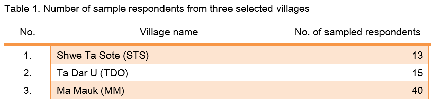
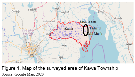
There were 68 sampled households in three selected villages from Kawa Township, Bago Region (Figure 1). Snowball sampling method (Flick U, 2018) was used to conduct the research objective with the semi-structure questionnaire. And key informant interview and focus group discussion are to collect the trend line of disaster impact and problems and their constraints and wants. The following Table 1 described the number of respondents per village for an individual in-depth interview. For data analysis, both descriptive analysis (i.e. mean, frequency, percentage and range) and one-way ANOVA (Kruskal-Wallis test) were employed to analyze the objectives of the study with the statistical package as R software (Version 3.4.2) and Microsoft Office Excel. In focus group discussion, the author used participatory tools to formulate the respondent’s answer such as trend line map for disaster impact by using resource map which is a tool to make a visualization of changes in a graph (Scheidergger Urs, 2007). Then, seasonal calendar (FAO, 2009) and ranking and scoring (Ashby JA, 1990) are used for the recent and possible livelihood activities in new place.
RESULTS AND DISCUSSION
Sociodemographic characteristics
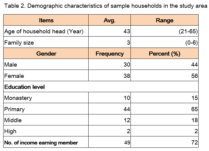
Descriptive analysis carried out and discussed are age, gender, farming experiences, household size, farm size, education status, primary job and the number of income-earning from family members in the selected villages in Kawa Township (KW). About 56% of females and 44% of males were the sampled respondents collected with the individual interviews in Table 2. The result showed that the average age of the household head was above 43 years old. Approximately 65% of sampled respondents had attended primary school level and 18% attended middle school. All respondents stated that 100% were married with a maximum of 6 family members but, an average of 3 members per household head. From the findings, around 72% of income family members earned a monthly income with US$97 from international migration. The number of household infrastructure assets results in 43% of respondents who had a zinc-roof house and 37% of respondents with bamboo-house in KW. There was only one respondent who works in agriculture with 7 acres for crop production. The majority of respondents stated that 22% of sampled respondents in KW work in fishery, 41% work as casual workers and a tiny portion work in livestock rearing and are self-employed.
TREND LINE OF LAND EROSION IN KAWA TOWNSHIP
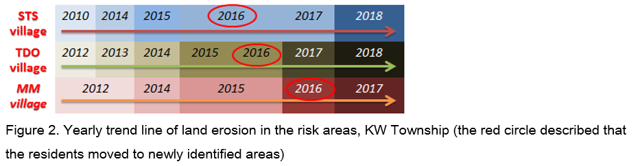
The result findings of the qualitative analysis came from the focus group discussion and resource map to formulate trend line of land erosion in the selected villages in Figure 2. In STS village, in 2016, land erosion washed away more than 2,000 acres of farmlands and moved to a newly identified area near one mile far from Gulf of Mottama. In TDO village, the residents from TDO village faced the extreme event of land erosion to the entire village which moved to the newly identified place for their security since 2016. The land erosion became worse in MM village since 2012 and 2017 which destroyed more than 7,500 acres and the entire MM village between 2013 and 2016. In 2016, most of the residents from MM village moved to the newly identified place near Kan Taw village. There is no occupied land for these internally displaced people to stay in the new recent area. The development of channel caused the extreme land erosion yearly with a peak in the rainy season. The Region of the Sittaung River is not well developed and not much navigation or economic activity happens at the Sittaung River (M.P.de Ridder, 2017). As for other difficulties, these villagers have a major problem for livelihood activity changes in this newly identified place when they move to this identified place. In Kawa Township, land erosion caused the highest impact for the risk area than flooding near the GoM. According to the results, flooding and land erosion affected by the severe occurrence of about 100% both in STS and TDO village and 95% in MM village. The major losses in these three villages in KW Township destroyed by the disasters were home, destroyed farmlands, crop yield, fish pond and livestock. Flooding and tidal bores resulted in the highest total number of destroyed farmlands in these three villages. The second-highest losses were found on respondents’ home and livestock such as pigs, cows and chickens. The livestock were highly impacted based on the sampled respondents. Chicken rearing faced the highest impact of flooding and tidal bores among all livestock. Typically, the natural disasters directly impacted on the farmland area, home and livestock rearing.
LIVELIHOOD ACTIVITIES IN THE DISASTER PRONE AREAS IN KAWA
Livelihood activities in newly identified areas
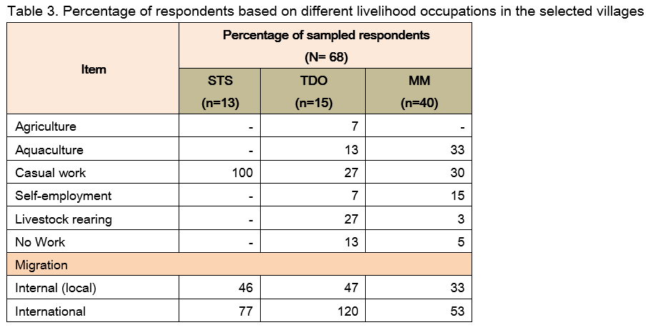
In disaster-prone areas in Kawa Township, 100% of farm households from STS village and above 27 % from TDO and 30% from MM village earned from the casual work and very few percent in livestock rearing and self-employment occupation, as shown in Table 3. As in the sampled households, the primary occupation was fishery and casual labor in MM village. There was a high percentage of internal and international migration labor from these villages in KW Township. In internal migration (local), there are above 40% each from STS and TDO villages and more than 33% in MM village as described in the Table. Migrant labors support their families in KW about an average salary US$41 per month from internal migrant labor and US$97 per month from international labor.
Seasonal calendar of recent livelihood activities
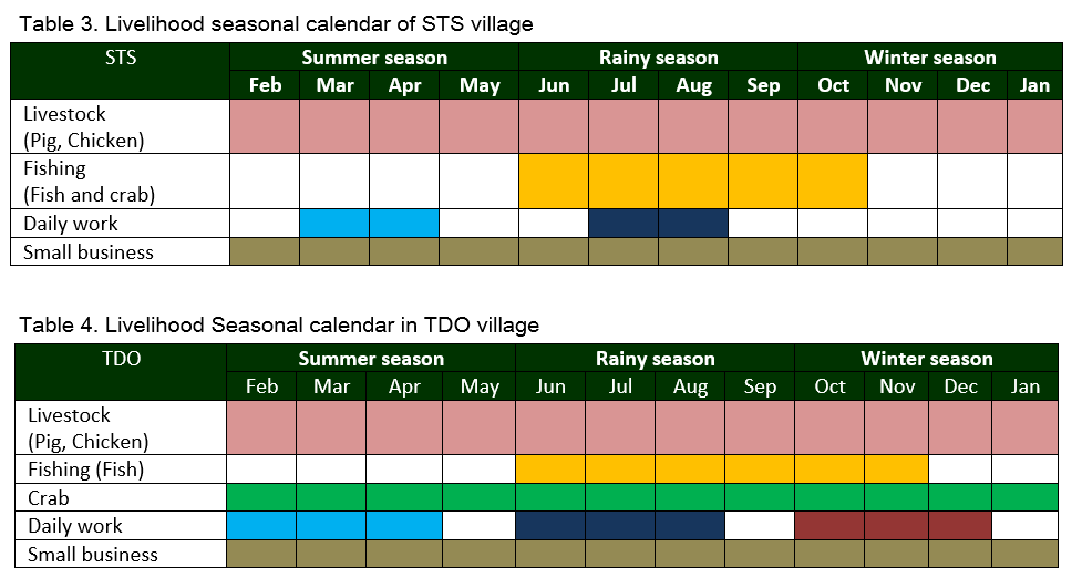
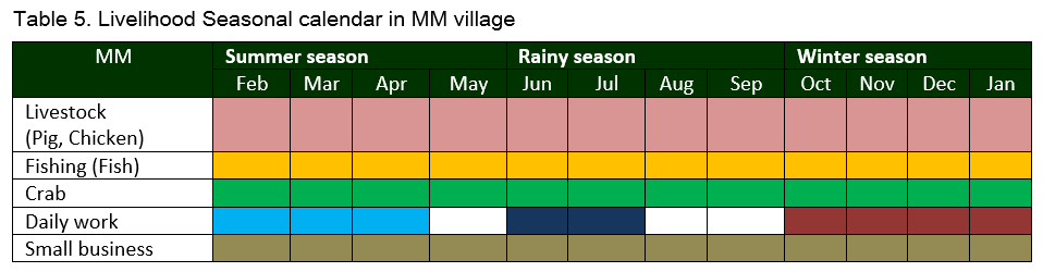
There are different recent opportunities to earn money for each village in natural disaster-prone areas at Kawa Township. According to the seasonal calendar, STS village can work only four kinds of livelihood activities, five kinds in TDO village and MM village. Besides, the workable duration of livelihood activities mentioned in each Table 3, 4 and 5. Fishing and crab fishing in STS village can work in between July and August during rainy season. Daily work consisted of rice growing/harvesting time of rice, pea and vegetables near the adjacent villages. Small businesses (shopkeeper) receive money from this kind of shops in the whole year when they sell vegetables and snacks and dried fish products in the village. In TDO village as found, livestock rearing and crab fishing can be done the whole year. Fishing can work between June and November for local and commercial fishermen in this village. Crab (US$ 1 per one crab) earned the second income generation than fish (on average US$2.5 per 1.63kg). Crab fishing is also a good option in TDO and MM villages which earned the same price for fish and crab. To summarize the findings, fishing and crab fishing are major activities in three selected villages in newly identified areas. According to the researchers Wongthong P and True J (2015), fishing earned the profit of 5 or 6 baskets (1 basket =25 kg) between October and November in KW Township. Dried fish is a common product which can be sold in the local and Bago markets. According to Myint T (2015), the researcher mentioned that most of the daily workers received work opportunity income from growing and harvesting time. TDO and MM villages received more chances to work on agribusiness with the wage nearly US$ 3 per day for female and US$5.7 per day for male than STS village. Livestock rearing earned nearly US$107 and US$143 per pig and US$3 per 1.63 kg from chicken. There were off-farm activities such as self-employment, casual workers, and carpenters earning the average income of US$ 200 from self-employment, US$124 from being casual workers and US$120 as carpenters, respectively. Additionally, dried fish and fish paste retailers and wholesalers received good income and price with value-added products from fishery in MM village. Surprisingly, MM have better livelihood security and opportunity and annual income than STS and TDO villages in newly identified areas near GoM Region. When the annual income is compared among these villages, the lowest amount of annual income is about more than 90% of sampled respondents from STS village and TDO village and more than 70% from MM village. Based on the study, it is possible to conclude that less diversified livelihood opportunities earned lower income in the disaster-prone areas.
Livelihood changes and potential livelihood activity by scoring
The major occupation before in STS village was agriculture (41%) which had the largest number of changes and had changed to the extra work (41%) and livestock rearing in the newly identified area of this village. In TDO village, the major occupation before disaster-prone situation was agriculture crop production (47%) which had the largest number of changes and had changed to livestock rearing in the disaster-prone areas. In the former situation, the second most livelihoods found was extra work (34%) which increased to around 39% in the recent situation in this village. After the disaster-prone situation, livestock rearing (7%) and the fishery (14%) were found to be additional income generation activities when the majority of respondents do not have their own land and there were no crop areas in the newly identified areas. In MM village, agriculture crop production and daily work were the major livelihood activities before disaster-prone situation. Meanwhile, after disaster-prone situation, agriculture crop production had changed dramatically, and fishery (14%) and extra work (39%) became the source of income in newly identified areas. According to the ranking for livelihood options by the respondents, STS and TDO villages mentioned that rice and green gram crop production is the highest ranking among all livelihood activities. Additionally, fishery and self-employment have the highest scores in MM village. In the disaster-prone areas, the majority of respondents from KW Township do not have farm lands and have low investments for crop production. For self-employment, bamboo and napalm seller mentioned as the high score from STS village which have the high demand for a new temporary house near the village. This region has improved livelihood security through effective fisheries value chain development, livelihoods diversification and equitable and sustainable management of resources (Wongthong P, True J, 2015).
EXISTING PLAN AND SUPPORT IN THE DISASTER-PRONE AREAS
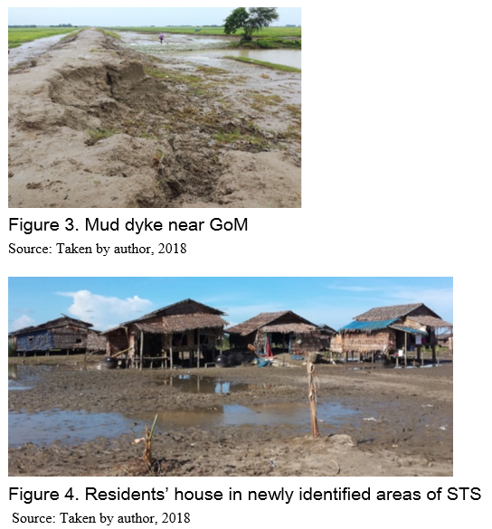
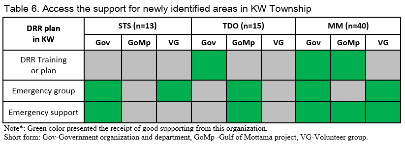
Disaster risk reduction plan is a major issue to recover from the effects of climate change events in the Gulf of Mottama Region. In Kawa Region, the selected villages also used the sandbag to control the flooding. Additionally, a control plan was established and that was the building of a mud dyke along Kawa Region supported by the government since 4 years ago. The coverage of mud dyke in 2018 did not work well to prevent the flooding and land erosion in the monsoon season. Therefore, the majority of villages moved to a new place near the mud or clay dyke supported by the government as shown in Figures 3 and 4. Based on the findings, the majority of respondents mentioned that most of these internally displaced villagers want to have a good dyke near their place. According to the report of coastal erosion (KMCO, 2018), the researcher mentioned that there were different kinds of disaster risk reduction with geotextile box, geo-tubes, timber structures, gabion mash boxes and rock revetment to cover the direction protection of the shore and land erosion. The green color coding described village received the support for DRR plan and recovery or emergency support in these disaster risk areas is in Table 6. In STS village, this village received the emergency group and support (drinking water, food, money) from a government department and disaster risk reduction training from the volunteer group. TDO village received the emergency group and supports from Gulf of Mottama project (GoMp) and disaster risk reduction training from a government department. Additionally, the government supports US$ 67 for the villagers to buy their own land in this new place. The Gulf of Mottama (GoMp) is supporting the village revolving fund to lend the loan to the project members of this village. The project is prepared to support the infrastructure and livestock rearing support from GoMp. MM village received more support than the other two villages as showed in Table 8. The disaster risk reduction training and some food and water supports from these three groups were supporting this MM village. Daw Khin Kyi foundation supported to develop the education in these newly identified areas since 2017. The Department of Rural Development supported the workshop and meeting with the Department of Land Management and statistics and Department of Irrigation and Water Utilization Management to find the newly identified place for this MM village. MM village received disaster risk reduction plan (DRR) training, law and regulation of local fishing and commercial fishing, land law and knowledge sharing from the project implementation of GoMp.
Constraints in the selected surveyed villages
Sampled respondents have to get the possible livelihood activities, drinking water and health care services. However, the sampled respondents faced the constraints of livelihood activities (53%) in STS and more than 20% in TDO and MM village. About 46% of the sampled respondents in TDO village faced the problem with drinking water and health care service. About 35% of the sampled respondents in MM village need the purify drinking water.
CONCLUSIONS AND RECOMMENDATIONS
This study examined the livelihood changes, disaster impact and potential mitigation for an internally displaced person in Kawa Township who faced low opportunity of livelihood activities and income sufficiency. The trend line of flooding and land erosion is worse year by year in the selected areas, and the impact is severe for livelihood security and entire village. According to the results, casual work is the main support for income-earning in STS village, whereas fishery is the main livelihood activity in TDO and MM villages. In this region, the majority of respondents (65%) completed primary school level and most of the sampled households have an average of 3 family members per household. In the study, 68 respondents included 46% males and 53 % females. Fishery and livestock breeding are the major occupations in TDO and MM villages and casual work is the major activity in the STS village. Land erosion had severe impact that destroyed farm, infrastructure, house and livestock compared to flooding in this region. About 72 % of family members earned supporting income to the family from internal (local) migration (US$41 per month) and international migration (US$97 per month). Based on the findings, MM village found more opportunity of livelihood than STS and TDO in the seasonal calendar which is connected with the annual income level group. The income level found that above 90 % of sampled respondents in STS and TDO villages, whereas only above 50% in MM village were included in the less-poor group. The author recognizes that agricultural crop production is a major livelihood activity before disaster risk situation, whereas fishery and livestock are the major livelihood activities after the disaster-prone situation in these three villages. According to the findings on the sampled respondents’ constraints in newly identified areas, the opportunity of livelihood activities and investments, drinking water access and health services are the major problems in each village. The potential livelihood ranking by respondents found that the majority of respondents want to work on agricultural crop production in the newly identified place if they would have farmlands. In MM village, the majority of respondents was willing to work in the commercial fishing and crabs fishing and need the technical knowledge and processing for value-added fishery product in this village. Consequently, the study concluded that the impact of land erosion in GoM directly changed the livelihood opportunity, income generation, living standards and education of youth for internally displaced people in these prone areas. The research findings recommend that there be potential further research with a more in-depth study on the consumption and living expenditure where are disaster-prone area and how to manage the disaster risk plan near the Gulf of Mottama. Government departments, NGO and INGO may need to support substantially for hygiene section and safe drinking water section in prone areas in KW Township. For the rural development organizations and departments they may take the action plan to recover for livelihood options mainly on agriculture, fishery and livestock rearing options and also revolving funds to create livelihood security and skill development plan.
REFERENCES
Ashby JA, 1990. Evaluating technologies with farmers: a handbook. Centro Internacional de Ag-ricultura Tropical (CIAT), Cali, Colombia, 95 p.
BRACED, 2017. BRACED Myanmar result report 2016-2017, Toward a resilient Myanmar, BREACE Myanmar Project, 2017, accessed on 2.1.2018. http://www.rcrc-resilience-southeastasia.org/wp-content/uploads/2017/09/...
FAO, 2009. FAO (Food and Agriculture Organization of the United Nations, Rome and International Labour Organization,Geneva), 2009. The livelihood assessment Tool-Kit. Analysing and responding on the livelihoods of people. First edition, 39–43, accessed on 28.03.2019.
Flick U, 2018. Designing qualitative research (2nd edition). SAGE, Los Angeles, CA, xvi, 180 Seiten
GoogleMap,2020. Google Map 2020: Kawa Map Township Map 2020, https://myanmar-streets.openalfa.com/kawa-township
Kopp Christoph, 2017. Analysis of variance (ANOVA). Handout in module T-3 R script, School of Agricultural, Forest and Food Sciences HAFL, Bern University of Applied Sciences, unpublished, accessed on 8.10.2017.
Koubi V, Stoll S, Spilker G, 2016. Perceptions of environmental change and migration decisions. Climatic Change, 138 (3-4), 439–451, accessed on 28.11.2017
M.P.de Ridder, 2017. The tidal bore in the Sittaung River. A sensitivity analyze of the propagation. Master Hydraulic Engineering and Water Resource Management, Delft University of Technology, Singapore, 50 p, accessed on 4.12.2018
Myint T, 2015. Non-fish value chain study. Community-Led Coastal Management in the Gulf of Mottama Project (CLCMGOMP), accessed on 27.03.2019.
Scheidergger Urs, 2007. Overview of diagnostic tools. Handout in module AF-01, Swiss College of Agriculture, Zollikofen, CH, unpublished.
Shi P, Yang X, Fang J, Wang J‘a, Xu W, Han G, 2016. Mapping and ranking global mortality, af-fected population and GDP loss risks for multiple climatic hazards. Journal of Geo-graphical Sciences, 26 (7), 878–888, accessed on 10.12.2017.
Wongthong P, True J, 2015. Updated situation analysis of the Gulf of Mottama. Based on the rapid socio-ecological assessment. Community-Led Coastal Management, accessed on 27.03.2019.

Internally Displaced People, Natural Disaster Risk Management, and Livelihood Changes: Case Study in Kawa Township, Bago Region
ABSTRACT
The main problem for internally displaced people after natural disaster is livelihood insecurity which contributes to other serious life sufficiency and health risks. The study investigates the socioeconomic, disaster risk and livelihood changes, disaster risk management and potential mitigation in the selected villages in Kawa Township, Bago Region of Myanmar. Snowball sampling technique was adopted in the collection of 68 rural households using a semi-structured questionnaire and focus group discussion. Both descriptive and qualitative analysis was employed to verify the objectives of the study. The result of the analysis showed that the majority of sampled households have a mean age of 43 years with an average family size of 3 people. The majority of sampled households completed primary school education (65%) and 72% of the income-earning member is from internal (US$41 per month) and international migration (US$97 per month). The study revealed that land erosion in these studied areas directly destroyed not only the farmlands, fish ponds and livestock and housing but also the residents’ place leading to internally displaced people. The findings showed that casual workers are the main recipients of opportunities for almost all of the respondents from STS village, with 27% from TDO and 33 % from MM village. Aquaculture is the highest potential in MM village with 33%, and 27% of the highest potential with livestock rearing in TDO village. The study revealed that the majority of respondents found in the less-poor group as above 90% in STS and TDO village and more than 50% in MM village. According to the seasonal calendar, the opportunity of livelihood activities found more activities in MM village than TDO and STS village. Agricultural crop production is a major livelihood activity before disaster risk situation and fishery and livestock are the major livelihood activities after disaster-prone situation. According to the results, the constraints in newly identified areas, the opportunity of livelihood activities and investments, drinking water access and health services are staggered out in each village. Consequently, the study summarized that the severe impact of land erosion in GoM directly changed the livelihood opportunity, income generation, living standard and education of youth for internally displaced people in these prone areas. It was recommended that livelihood opportunity and disaster risk reduction plan should be adequately improved with a skill development plan and loan access for investments and implementation training for risk management of climate change in these areas.
Keywords: socioeconomics, livelihood changes and potential opportunity, disaster and risk reduction management
INTRODUCTION
Conflict intensifies vulnerability to natural hazards and increases the level of poverty in the affected area on internally displaced people (IDP) and refugees over the world. A big global issue is climate change which includes temperature increases or decreases, sea-level rise, and the intensification of natural hazards such as cyclones, floods, and droughts (Koubi V et al. 2016). The south-east part of Myanmar is prone to regular flash flooding and major storms every year in the rainy season (BRACED, 2017). In Global statistics, the internally displaced persons generally reinforce by counting only those displaced by conflict or uprooted by a natural disaster (Shi P et al. 2016). According to the report of Myanmar floods (2018), Bago Region has the highest number (144,624) of internally displaced people compared to the other regions/states in 2018. The majority of the village in Bago Region has faced entire villages thrown away by the land erosion in this area. Additionally, according to the report of Helvetas Myanmar (KMCO, 2018), the major affected areas in the Bago Region are near the Sittaung River bank villages from two townships, Kawa and Tha Nat Pin Township. This research was carried out through the socio-economic characteristic of sampled households in three villages of Kawa Township with the objectives of (1) investigating trend line of natural disaster and livelihood changes before and after disaster impact; (2) determining livelihood activities changes and potential activities by ranking score; and (3) finding out the disaster risk reduction management plan and support for internally displaced people in the selected areas in Kawa Township.
METHODOLOGY
Data collection and sampling technique
There were 68 sampled households in three selected villages from Kawa Township, Bago Region (Figure 1). Snowball sampling method (Flick U, 2018) was used to conduct the research objective with the semi-structure questionnaire. And key informant interview and focus group discussion are to collect the trend line of disaster impact and problems and their constraints and wants. The following Table 1 described the number of respondents per village for an individual in-depth interview. For data analysis, both descriptive analysis (i.e. mean, frequency, percentage and range) and one-way ANOVA (Kruskal-Wallis test) were employed to analyze the objectives of the study with the statistical package as R software (Version 3.4.2) and Microsoft Office Excel. In focus group discussion, the author used participatory tools to formulate the respondent’s answer such as trend line map for disaster impact by using resource map which is a tool to make a visualization of changes in a graph (Scheidergger Urs, 2007). Then, seasonal calendar (FAO, 2009) and ranking and scoring (Ashby JA, 1990) are used for the recent and possible livelihood activities in new place.
RESULTS AND DISCUSSION
Sociodemographic characteristics
Descriptive analysis carried out and discussed are age, gender, farming experiences, household size, farm size, education status, primary job and the number of income-earning from family members in the selected villages in Kawa Township (KW). About 56% of females and 44% of males were the sampled respondents collected with the individual interviews in Table 2. The result showed that the average age of the household head was above 43 years old. Approximately 65% of sampled respondents had attended primary school level and 18% attended middle school. All respondents stated that 100% were married with a maximum of 6 family members but, an average of 3 members per household head. From the findings, around 72% of income family members earned a monthly income with US$97 from international migration. The number of household infrastructure assets results in 43% of respondents who had a zinc-roof house and 37% of respondents with bamboo-house in KW. There was only one respondent who works in agriculture with 7 acres for crop production. The majority of respondents stated that 22% of sampled respondents in KW work in fishery, 41% work as casual workers and a tiny portion work in livestock rearing and are self-employed.
TREND LINE OF LAND EROSION IN KAWA TOWNSHIP
The result findings of the qualitative analysis came from the focus group discussion and resource map to formulate trend line of land erosion in the selected villages in Figure 2. In STS village, in 2016, land erosion washed away more than 2,000 acres of farmlands and moved to a newly identified area near one mile far from Gulf of Mottama. In TDO village, the residents from TDO village faced the extreme event of land erosion to the entire village which moved to the newly identified place for their security since 2016. The land erosion became worse in MM village since 2012 and 2017 which destroyed more than 7,500 acres and the entire MM village between 2013 and 2016. In 2016, most of the residents from MM village moved to the newly identified place near Kan Taw village. There is no occupied land for these internally displaced people to stay in the new recent area. The development of channel caused the extreme land erosion yearly with a peak in the rainy season. The Region of the Sittaung River is not well developed and not much navigation or economic activity happens at the Sittaung River (M.P.de Ridder, 2017). As for other difficulties, these villagers have a major problem for livelihood activity changes in this newly identified place when they move to this identified place. In Kawa Township, land erosion caused the highest impact for the risk area than flooding near the GoM. According to the results, flooding and land erosion affected by the severe occurrence of about 100% both in STS and TDO village and 95% in MM village. The major losses in these three villages in KW Township destroyed by the disasters were home, destroyed farmlands, crop yield, fish pond and livestock. Flooding and tidal bores resulted in the highest total number of destroyed farmlands in these three villages. The second-highest losses were found on respondents’ home and livestock such as pigs, cows and chickens. The livestock were highly impacted based on the sampled respondents. Chicken rearing faced the highest impact of flooding and tidal bores among all livestock. Typically, the natural disasters directly impacted on the farmland area, home and livestock rearing.
LIVELIHOOD ACTIVITIES IN THE DISASTER PRONE AREAS IN KAWA
Livelihood activities in newly identified areas
In disaster-prone areas in Kawa Township, 100% of farm households from STS village and above 27 % from TDO and 30% from MM village earned from the casual work and very few percent in livestock rearing and self-employment occupation, as shown in Table 3. As in the sampled households, the primary occupation was fishery and casual labor in MM village. There was a high percentage of internal and international migration labor from these villages in KW Township. In internal migration (local), there are above 40% each from STS and TDO villages and more than 33% in MM village as described in the Table. Migrant labors support their families in KW about an average salary US$41 per month from internal migrant labor and US$97 per month from international labor.
Seasonal calendar of recent livelihood activities
There are different recent opportunities to earn money for each village in natural disaster-prone areas at Kawa Township. According to the seasonal calendar, STS village can work only four kinds of livelihood activities, five kinds in TDO village and MM village. Besides, the workable duration of livelihood activities mentioned in each Table 3, 4 and 5. Fishing and crab fishing in STS village can work in between July and August during rainy season. Daily work consisted of rice growing/harvesting time of rice, pea and vegetables near the adjacent villages. Small businesses (shopkeeper) receive money from this kind of shops in the whole year when they sell vegetables and snacks and dried fish products in the village. In TDO village as found, livestock rearing and crab fishing can be done the whole year. Fishing can work between June and November for local and commercial fishermen in this village. Crab (US$ 1 per one crab) earned the second income generation than fish (on average US$2.5 per 1.63kg). Crab fishing is also a good option in TDO and MM villages which earned the same price for fish and crab. To summarize the findings, fishing and crab fishing are major activities in three selected villages in newly identified areas. According to the researchers Wongthong P and True J (2015), fishing earned the profit of 5 or 6 baskets (1 basket =25 kg) between October and November in KW Township. Dried fish is a common product which can be sold in the local and Bago markets. According to Myint T (2015), the researcher mentioned that most of the daily workers received work opportunity income from growing and harvesting time. TDO and MM villages received more chances to work on agribusiness with the wage nearly US$ 3 per day for female and US$5.7 per day for male than STS village. Livestock rearing earned nearly US$107 and US$143 per pig and US$3 per 1.63 kg from chicken. There were off-farm activities such as self-employment, casual workers, and carpenters earning the average income of US$ 200 from self-employment, US$124 from being casual workers and US$120 as carpenters, respectively. Additionally, dried fish and fish paste retailers and wholesalers received good income and price with value-added products from fishery in MM village. Surprisingly, MM have better livelihood security and opportunity and annual income than STS and TDO villages in newly identified areas near GoM Region. When the annual income is compared among these villages, the lowest amount of annual income is about more than 90% of sampled respondents from STS village and TDO village and more than 70% from MM village. Based on the study, it is possible to conclude that less diversified livelihood opportunities earned lower income in the disaster-prone areas.
Livelihood changes and potential livelihood activity by scoring
The major occupation before in STS village was agriculture (41%) which had the largest number of changes and had changed to the extra work (41%) and livestock rearing in the newly identified area of this village. In TDO village, the major occupation before disaster-prone situation was agriculture crop production (47%) which had the largest number of changes and had changed to livestock rearing in the disaster-prone areas. In the former situation, the second most livelihoods found was extra work (34%) which increased to around 39% in the recent situation in this village. After the disaster-prone situation, livestock rearing (7%) and the fishery (14%) were found to be additional income generation activities when the majority of respondents do not have their own land and there were no crop areas in the newly identified areas. In MM village, agriculture crop production and daily work were the major livelihood activities before disaster-prone situation. Meanwhile, after disaster-prone situation, agriculture crop production had changed dramatically, and fishery (14%) and extra work (39%) became the source of income in newly identified areas. According to the ranking for livelihood options by the respondents, STS and TDO villages mentioned that rice and green gram crop production is the highest ranking among all livelihood activities. Additionally, fishery and self-employment have the highest scores in MM village. In the disaster-prone areas, the majority of respondents from KW Township do not have farm lands and have low investments for crop production. For self-employment, bamboo and napalm seller mentioned as the high score from STS village which have the high demand for a new temporary house near the village. This region has improved livelihood security through effective fisheries value chain development, livelihoods diversification and equitable and sustainable management of resources (Wongthong P, True J, 2015).
EXISTING PLAN AND SUPPORT IN THE DISASTER-PRONE AREAS
Disaster risk reduction plan is a major issue to recover from the effects of climate change events in the Gulf of Mottama Region. In Kawa Region, the selected villages also used the sandbag to control the flooding. Additionally, a control plan was established and that was the building of a mud dyke along Kawa Region supported by the government since 4 years ago. The coverage of mud dyke in 2018 did not work well to prevent the flooding and land erosion in the monsoon season. Therefore, the majority of villages moved to a new place near the mud or clay dyke supported by the government as shown in Figures 3 and 4. Based on the findings, the majority of respondents mentioned that most of these internally displaced villagers want to have a good dyke near their place. According to the report of coastal erosion (KMCO, 2018), the researcher mentioned that there were different kinds of disaster risk reduction with geotextile box, geo-tubes, timber structures, gabion mash boxes and rock revetment to cover the direction protection of the shore and land erosion. The green color coding described village received the support for DRR plan and recovery or emergency support in these disaster risk areas is in Table 6. In STS village, this village received the emergency group and support (drinking water, food, money) from a government department and disaster risk reduction training from the volunteer group. TDO village received the emergency group and supports from Gulf of Mottama project (GoMp) and disaster risk reduction training from a government department. Additionally, the government supports US$ 67 for the villagers to buy their own land in this new place. The Gulf of Mottama (GoMp) is supporting the village revolving fund to lend the loan to the project members of this village. The project is prepared to support the infrastructure and livestock rearing support from GoMp. MM village received more support than the other two villages as showed in Table 8. The disaster risk reduction training and some food and water supports from these three groups were supporting this MM village. Daw Khin Kyi foundation supported to develop the education in these newly identified areas since 2017. The Department of Rural Development supported the workshop and meeting with the Department of Land Management and statistics and Department of Irrigation and Water Utilization Management to find the newly identified place for this MM village. MM village received disaster risk reduction plan (DRR) training, law and regulation of local fishing and commercial fishing, land law and knowledge sharing from the project implementation of GoMp.
Constraints in the selected surveyed villages
Sampled respondents have to get the possible livelihood activities, drinking water and health care services. However, the sampled respondents faced the constraints of livelihood activities (53%) in STS and more than 20% in TDO and MM village. About 46% of the sampled respondents in TDO village faced the problem with drinking water and health care service. About 35% of the sampled respondents in MM village need the purify drinking water.
CONCLUSIONS AND RECOMMENDATIONS
This study examined the livelihood changes, disaster impact and potential mitigation for an internally displaced person in Kawa Township who faced low opportunity of livelihood activities and income sufficiency. The trend line of flooding and land erosion is worse year by year in the selected areas, and the impact is severe for livelihood security and entire village. According to the results, casual work is the main support for income-earning in STS village, whereas fishery is the main livelihood activity in TDO and MM villages. In this region, the majority of respondents (65%) completed primary school level and most of the sampled households have an average of 3 family members per household. In the study, 68 respondents included 46% males and 53 % females. Fishery and livestock breeding are the major occupations in TDO and MM villages and casual work is the major activity in the STS village. Land erosion had severe impact that destroyed farm, infrastructure, house and livestock compared to flooding in this region. About 72 % of family members earned supporting income to the family from internal (local) migration (US$41 per month) and international migration (US$97 per month). Based on the findings, MM village found more opportunity of livelihood than STS and TDO in the seasonal calendar which is connected with the annual income level group. The income level found that above 90 % of sampled respondents in STS and TDO villages, whereas only above 50% in MM village were included in the less-poor group. The author recognizes that agricultural crop production is a major livelihood activity before disaster risk situation, whereas fishery and livestock are the major livelihood activities after the disaster-prone situation in these three villages. According to the findings on the sampled respondents’ constraints in newly identified areas, the opportunity of livelihood activities and investments, drinking water access and health services are the major problems in each village. The potential livelihood ranking by respondents found that the majority of respondents want to work on agricultural crop production in the newly identified place if they would have farmlands. In MM village, the majority of respondents was willing to work in the commercial fishing and crabs fishing and need the technical knowledge and processing for value-added fishery product in this village. Consequently, the study concluded that the impact of land erosion in GoM directly changed the livelihood opportunity, income generation, living standards and education of youth for internally displaced people in these prone areas. The research findings recommend that there be potential further research with a more in-depth study on the consumption and living expenditure where are disaster-prone area and how to manage the disaster risk plan near the Gulf of Mottama. Government departments, NGO and INGO may need to support substantially for hygiene section and safe drinking water section in prone areas in KW Township. For the rural development organizations and departments they may take the action plan to recover for livelihood options mainly on agriculture, fishery and livestock rearing options and also revolving funds to create livelihood security and skill development plan.
REFERENCES
Ashby JA, 1990. Evaluating technologies with farmers: a handbook. Centro Internacional de Ag-ricultura Tropical (CIAT), Cali, Colombia, 95 p.
BRACED, 2017. BRACED Myanmar result report 2016-2017, Toward a resilient Myanmar, BREACE Myanmar Project, 2017, accessed on 2.1.2018. http://www.rcrc-resilience-southeastasia.org/wp-content/uploads/2017/09/...
FAO, 2009. FAO (Food and Agriculture Organization of the United Nations, Rome and International Labour Organization,Geneva), 2009. The livelihood assessment Tool-Kit. Analysing and responding on the livelihoods of people. First edition, 39–43, accessed on 28.03.2019.
Flick U, 2018. Designing qualitative research (2nd edition). SAGE, Los Angeles, CA, xvi, 180 Seiten
GoogleMap,2020. Google Map 2020: Kawa Map Township Map 2020, https://myanmar-streets.openalfa.com/kawa-township
Kopp Christoph, 2017. Analysis of variance (ANOVA). Handout in module T-3 R script, School of Agricultural, Forest and Food Sciences HAFL, Bern University of Applied Sciences, unpublished, accessed on 8.10.2017.
Koubi V, Stoll S, Spilker G, 2016. Perceptions of environmental change and migration decisions. Climatic Change, 138 (3-4), 439–451, accessed on 28.11.2017
M.P.de Ridder, 2017. The tidal bore in the Sittaung River. A sensitivity analyze of the propagation. Master Hydraulic Engineering and Water Resource Management, Delft University of Technology, Singapore, 50 p, accessed on 4.12.2018
Myint T, 2015. Non-fish value chain study. Community-Led Coastal Management in the Gulf of Mottama Project (CLCMGOMP), accessed on 27.03.2019.
Scheidergger Urs, 2007. Overview of diagnostic tools. Handout in module AF-01, Swiss College of Agriculture, Zollikofen, CH, unpublished.
Shi P, Yang X, Fang J, Wang J‘a, Xu W, Han G, 2016. Mapping and ranking global mortality, af-fected population and GDP loss risks for multiple climatic hazards. Journal of Geo-graphical Sciences, 26 (7), 878–888, accessed on 10.12.2017.
Wongthong P, True J, 2015. Updated situation analysis of the Gulf of Mottama. Based on the rapid socio-ecological assessment. Community-Led Coastal Management, accessed on 27.03.2019.