ABSTRACT
Precision farming or precision agriculture is a holistic system to manage the agriculture by integrating several technologies to monitor the field in an accurate way. It is also known as 3R, right Input, right location and right time. Rice has been planted widely in Malaysia. It is a staple food for Malaysian people and the second most important food in the world after wheat. Scientific name of rice is Oryza sativa and comes from the family of Poaceae. The average consumption of rice by adults in Malaysia is two and half plates per day. Malaysia produces rice at about 72% of the nation's self-sufficiency level and the government intends to increase the percentage in the coming years to above 90% by 2020 to meet the requirements of the growing population. In order to increase rice production, the usage of precision farming is vital as it is able to aid in monitoring crop’s growth effectively. Thus, as a part of precision farming technologies, a decision support system such as a web application system or also known as a Web Paddy GIS can be used to help the government to increase rice production in the country. The web system is able to store, manage, analyze and visualize all the information in one platform that can be accessed by all people related to rice growth monitoring using their smart phone. Therefore, the objectives of this study were to design the architecture of Web Paddy GIS by using free and open source software for agriculture officers and farmers in Tanjung Karang area. The data stored includes agriculture information, plot information (locality) and pest and disease information. All the data collected were stored in the database server. The Web Paddy GIS could provide beneficial information for monitoring rice growth in the field. Web Paddy GIS gives an opportunity to the agriculture officer and farmers to integrate and access all the pest and disease information and other information for rice and to improve the agriculture management by utilizing Information and Communications Technology (ICT) in globalization era.
Keywords: Web GIS, precision farming, open source, Decision Support System, rice mapping
INTRODUCTION
Paddy crop is a main crop and widely planted in Malaysia. It is our staple food and it is the second most important food in the world after wheat (Rajamoorthy et al. 2015). The Scientific name of rice is Oryza sativa and it comes from family of Poaceae. Malaysia produces about 72% of the nation's rice self-sufficiency level (SSL) and Malaysian government needs to increase the percentage to more than 90% by 2020 due to the population increase. The consumption of rice in Malaysia for an adult was two and half plates of rice per day on average (Rajamoorthy et al. 2015). Thus, there is a need to increase the yield due to high demand of rice. This is can be increased by good agriculture practices in the field with accurate information and knowledge.
The information needs to be updated and should be easy to access to the users. For example, open source (OS) is an alternative solution to help agriculture officers and farmers to use a free system to manage the crop fields. No cost needed to develop the system and it is easier and quicker to use in monitoring and managing the pests and diseases at the paddy field compared to commercial softwares that are very expensive and farmers can’t afford such systems. The web application in agriculture can be used to store all the data collected by agriculture officers during their site visits. The data can be reviewed from the web browser through the internet accessed by using computers or smart phones at anytime and anywhere. Many applications can be made using the web-based system such as harvest time and location, yield information, plot information and pest and disease information and update the reports using cloud computing to improve the management.
Agriculture officers and farmers lack the knowledge and information about their fields such as pests and diseases (PnD), soil information, crop nutrients and other information in their paddy fields (Uwais 2019). To date, there is no interactive system that can be used by the officers and farmers to access the information and update any outbreaks within their area (Uwais 2019). This situation will give bad impact to their management in controlling pest and disease and manage their field due to their lacking in knowledge and information regarding pest and disease and any other important information like how to control the PnD. Thus, Web Paddy GISis a solution for them to get a real-time information using their computer or smart phone. By using Web Paddy GIS, the users can store all the informative data in the online database and display the data at any time using the internet access.
Table 1 shows the agriculture system in Malaysia. It indicates that the usage of ICTs in agriculture is still low but high preference in commercial software and offline system.
Table 1. The agriculture system in Malaysia
|
SOURCE
|
CONTRIBUTION
|
ISSUE
|
|
Research and development on paddy field (Amin, 2008).
|
Improving irrigation management.
|
Offline base, use commercial software.
|
|
PADDY GIS (Fauzul, 2008).
|
GIS to assist in farm management.
|
System is offline based and used Arc Map.
|
|
RIMIS (Roshwan, 2008).
|
Irrigation water allocation.
|
System is offline based, focus only on irrigation and used Arc Map.
|
|
Visualization for Pest Infection on rice
(Lajis et al. 2016).
|
Pest infection visualization.
|
Use commercial software.
|
|
Paddy2U (Rice management mobile apps) (Athirah et. al 2019)
|
Rice management
|
Use commercial software.
|
The usage of the web-based application in agriculture is still low and new in Malaysia. The systems that had been developed were mostly offline system and used expensive commercial softwares which made the systems costly. Thus, in this study, the open source software is a solution to develop the real time system at a low cost. Users can access the information using their smart phones at any time or any place. Users also can access and get updates on their plot via Web Paddy GIS with internet availability.
METHODOLOGY
Methodology workflow
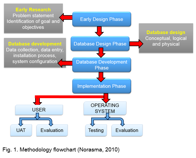
Figure 1 shows the workflow of the methodology for Web Paddy GIS. In this system, there were four main phases, which were early design phase, database design phase, database development phases and implementation phase. Early research design phase was to identify problem statements and goal or objectives of this research. The second phase was database design phase consists of conceptual, logical and physical design. Third phase was database development phase. It involved data collection, data entry, installation process and system configuration. The final phase was implementation phase. The implementation phase was testing the Web Paddy GIS to the end user and get the feedback from the users (Norasma 2010).
System architecture for Web Paddy GIS
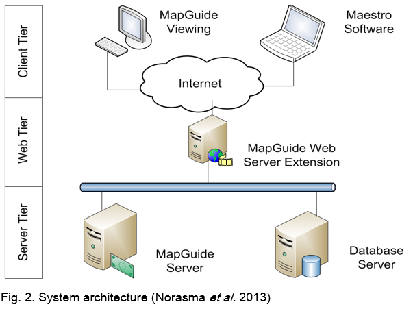
Figure 2 shows the architecture of Web Paddy GIS. It consists of 3 tiers (i.e. client tier, Web tier and server tier). The client tier is utilized by Web users. Starting from the client tier, developer can update information and data from the Map Guide and Maestro software. All data that is uploaded will be stored in the database server (SQL server) at server tier. The farmers or users can access the information at client tier through the connection with the Web tier. The Web Server extension is accessed through the Web Application Programming Interface (API) and is an internal component that performs the backend processes. MapGuide server is to store all the spatial data in the database (Norasma et al. 2013).
Data collection
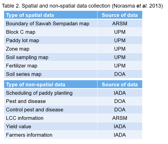
Table 2 shows the data collection and acquisition for the Web Paddy GIS. The boundary of the Sawah Sempadan and Leaf Color Chart (LCC) were gained from the Agency Remote Sensing Malaysia (ARSM). The block C map, paddy lot map, zone map, soil sampling map, fertilizer map were collected by Universiti Putra Malaysia (UPM). While the soil map, PnD and how to control PnD were acquired from the Department of Agriculture (DOA). Scheduling of paddy planting, yield of prediction and farmers information were taken from the Integrated Agriculture Development Area (IADA) Tanjung Karang.
Web paddy GIS module and decision support system
Figure 3 shows the module in the Web Paddy GIS. It is consist with scheduling information, PnD, Control system for PnD, fertilizer application, farmer’s information, yield application, Leaf Color Chart (LCC), Forum discussion and mapping application.
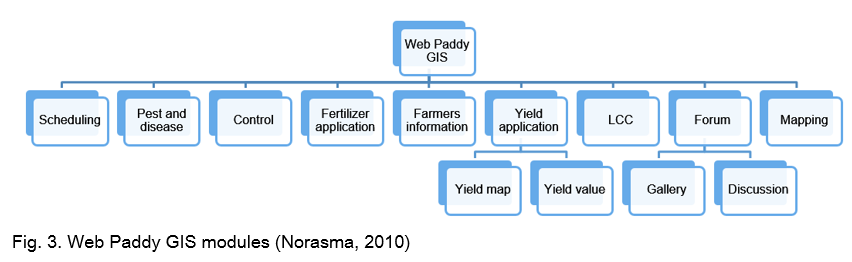
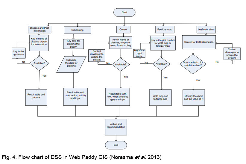
Figure 4 shows the DSS process in the Web Paddy GIS. All the modules are set up to calculate the information and the Web Paddy GIS will suggest the best decision for the action and recommendation to the users. Users can do the fast action based on the recommendation from the Web Paddy GIS.
User acceptance test (UAT)
Web Paddy GIS has been testing to the farmers at Tanjung Karang. The testing was done to the farmers and agriculture officer to see the performance and interaction with the Web Paddy GIS. During the testing, farmers also asked some questioned and gave some suggestion to improve the GUI to make it easy to use and understand especially for the older farmers. Since, everyone uses smartphone nowadays, the Web Paddy GIS can be accessed through their smartphones.
RESULTS
User graphic interface (GUI) of Web paddy GIS
Table 3 shows the description of each menu of GUI in the Web Paddy GIS. Started with the main menu, introduction, agriculture information, E-paddy, controlling PnD, Gallery and forum for user discussion and interaction. The details of each menus are descript in the Table 2.
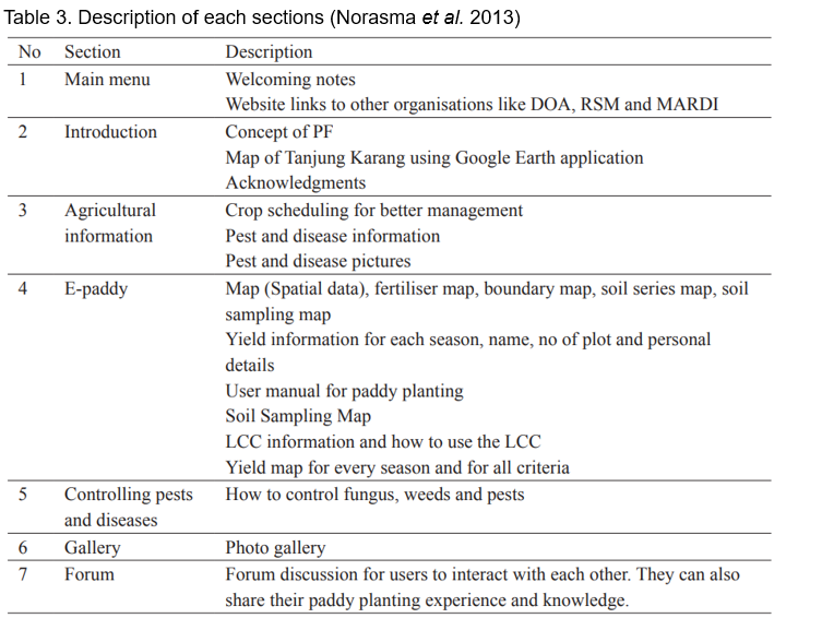
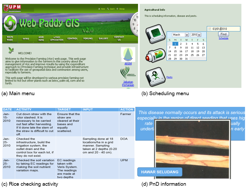
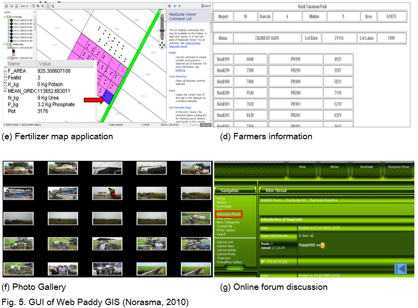
Figure 5 shows the GUI of each section in the Web Paddy GIS. It shows the main menu in the Web Paddy GIS (a), scheduling and rice check (b and c), PnD information (d), fertilizer map application (e), farmers information (f) and photo gallery and forum discussion (g and h). The fertilizer map application is really important to farmers because it helps farmers to provide the precise input for their paddy plot based on the spatial analysis. Thus, farmers can save a lot of effort and at the same time save the environment from excessive chemical usage. The advantage of Web Paddy GIS is the function of the spatial visualization and fertilizer application map. The fertilizer application map was generated by the calculation of the current nutrient content in the soil and recommendation made based on the variability nutrient information at the particular plot. Some of the plots need more input while some have enough nutrients and are already high in the nutrient content. Traditional practice farmers just apply the standard rate to the whole area but now, they can apply based on the fertilizer application map. Result from the yield shows that plots that follow the recommendation map produced higher yield compare to the normal practice.
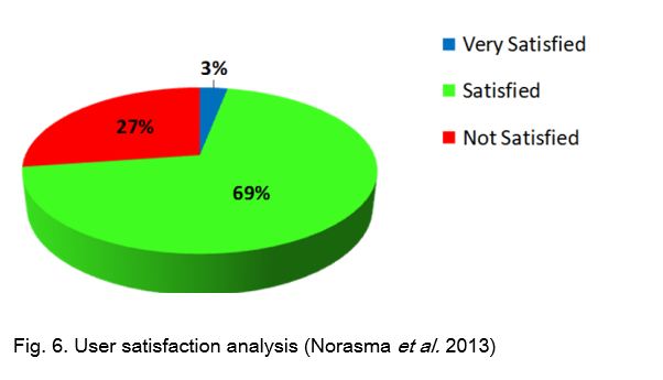
The Web Paddy GIS also shows very high satisfaction from the farmers based on the analysis and testing at the field with the farmers and agriculture officer. Figure 6 shows 70% of the respondents are satisfied with the performance and content of Web Paddy GIS. Only 27% are not satisfied and this is because of the not familiar with the smartphone and most of them are older farmers. However, this result is really good and more functions can be modified to improve the Web Paddy GIS. It shows the Web Paddy GIS can help user to improve their management. The function in the Web Paddy GIS can be improved in the future based on the feedback and suggestions from the users.
CONCLUSION
Web Paddy GIS is one of the stepping stones of researchers to explore more in Information and Communication Technologies (ICTs) in agriculture. Since the Government is trying to enhance digital farming in Malaysia, this is a good example to improve agriculture management using ICTs to increase the yield. Farmers are also happy to adapt to a new technology for their field since everyone is familiar with the Internet and smartphone technology. Precise information is really needed to help farmers in taking fast action to increase their yield and income. Web Paddy GIS can be improved further to match the current information and conditions of the soil, crops and climate.
REFERENCES
Athirah, R.N., C.Y.N. Norasma, M.R. Ismail, F. Azali, M.H. Omar, 2019. “PADI2U: Development of smartphone for rice management in KADA Kelantan”, National Convention of Agricultural & Food Engineering 2019, Putrajaya (2019) (In Malay)
Amin, M.S.M, 2008. Research and Development on precision farming of rice at Universiti Putra Malaysia. Paper presented at Consulting Workshop on Paddy Precision Farming, Malaysia Agro Exposition Park Serdang, Malaysia. August 2008
Acharya, S.N., H.C. Huang, and M.R. Hanna, 1995. Cultivar description: ‘AC Blue J’ alfalfa. Canadian Journal of Plant Science 75:469-471.
Fauzul, A., A.R.M, Shariff, A.R. Anuar, J. Ebrahim, and C.Y.N. Norasma, 2008. GIS based system for paddy precision farming. In World conference on agricultural information and IT, IAALD AFITA WCCA 2008, Tokyo University of Agriculture, Tokyo, Japan, 24-27 August, 2008 (pp. 417-422). Tokyo University of Agriculture (https://www.cabdirect.org/cabdirect/abstract/20083298086, Accessed 4 July 2019)
Lajis, A., H.M. Nasir, and N. Ismail, 2016. Web GIS based information visualization for pest infection: a case study of rice plantation. Asian J Plant Sci, 15(3-4), 109-114.
Norasma, C.Y.N., A.R.M Shariff, E.Jahanshiri, M.S.M. Amin, S.Khairunniza-Bejo, and A.R. Mahmud, 2013. Web-based decision support system for paddy planting management. Pertanika Journal of Science & Technology, 21(2), 343-364.
Norasma, C.Y.N., 2010. Web-based GIS Decision Support System for Paddy Precision Farming, Master thesis from Universiti Putra Malaysia
Rajamoorthy, Y., K.B.A. Rahim, and S. Munusamy, 2015. Rice Industry in Malaysia: Challenges, Policies and Implications. Procedia Economics and Finance, 31, 861–867.
Rowshan, M.K., and M.S.M. Amin, 2008. Rice irrigation management information system (RIMIS). Paper presented at Consulting Workshop on Paddy Precision Farming, Malaysia Agro Exposition Park Serdang, Malaysia. August 2008.
Uwais, A.A., 2019. Development of Paddy Pest and Disease Web System, Final year project thesis from Universiti Putra Malaysia


Development of Web-Based Decision Support System for Paddy Planting Management in Tanjung Karang, Malaysia
ABSTRACT
Precision farming or precision agriculture is a holistic system to manage the agriculture by integrating several technologies to monitor the field in an accurate way. It is also known as 3R, right Input, right location and right time. Rice has been planted widely in Malaysia. It is a staple food for Malaysian people and the second most important food in the world after wheat. Scientific name of rice is Oryza sativa and comes from the family of Poaceae. The average consumption of rice by adults in Malaysia is two and half plates per day. Malaysia produces rice at about 72% of the nation's self-sufficiency level and the government intends to increase the percentage in the coming years to above 90% by 2020 to meet the requirements of the growing population. In order to increase rice production, the usage of precision farming is vital as it is able to aid in monitoring crop’s growth effectively. Thus, as a part of precision farming technologies, a decision support system such as a web application system or also known as a Web Paddy GIS can be used to help the government to increase rice production in the country. The web system is able to store, manage, analyze and visualize all the information in one platform that can be accessed by all people related to rice growth monitoring using their smart phone. Therefore, the objectives of this study were to design the architecture of Web Paddy GIS by using free and open source software for agriculture officers and farmers in Tanjung Karang area. The data stored includes agriculture information, plot information (locality) and pest and disease information. All the data collected were stored in the database server. The Web Paddy GIS could provide beneficial information for monitoring rice growth in the field. Web Paddy GIS gives an opportunity to the agriculture officer and farmers to integrate and access all the pest and disease information and other information for rice and to improve the agriculture management by utilizing Information and Communications Technology (ICT) in globalization era.
Keywords: Web GIS, precision farming, open source, Decision Support System, rice mapping
INTRODUCTION
Paddy crop is a main crop and widely planted in Malaysia. It is our staple food and it is the second most important food in the world after wheat (Rajamoorthy et al. 2015). The Scientific name of rice is Oryza sativa and it comes from family of Poaceae. Malaysia produces about 72% of the nation's rice self-sufficiency level (SSL) and Malaysian government needs to increase the percentage to more than 90% by 2020 due to the population increase. The consumption of rice in Malaysia for an adult was two and half plates of rice per day on average (Rajamoorthy et al. 2015). Thus, there is a need to increase the yield due to high demand of rice. This is can be increased by good agriculture practices in the field with accurate information and knowledge.
The information needs to be updated and should be easy to access to the users. For example, open source (OS) is an alternative solution to help agriculture officers and farmers to use a free system to manage the crop fields. No cost needed to develop the system and it is easier and quicker to use in monitoring and managing the pests and diseases at the paddy field compared to commercial softwares that are very expensive and farmers can’t afford such systems. The web application in agriculture can be used to store all the data collected by agriculture officers during their site visits. The data can be reviewed from the web browser through the internet accessed by using computers or smart phones at anytime and anywhere. Many applications can be made using the web-based system such as harvest time and location, yield information, plot information and pest and disease information and update the reports using cloud computing to improve the management.
Agriculture officers and farmers lack the knowledge and information about their fields such as pests and diseases (PnD), soil information, crop nutrients and other information in their paddy fields (Uwais 2019). To date, there is no interactive system that can be used by the officers and farmers to access the information and update any outbreaks within their area (Uwais 2019). This situation will give bad impact to their management in controlling pest and disease and manage their field due to their lacking in knowledge and information regarding pest and disease and any other important information like how to control the PnD. Thus, Web Paddy GISis a solution for them to get a real-time information using their computer or smart phone. By using Web Paddy GIS, the users can store all the informative data in the online database and display the data at any time using the internet access.
Table 1 shows the agriculture system in Malaysia. It indicates that the usage of ICTs in agriculture is still low but high preference in commercial software and offline system.
Table 1. The agriculture system in Malaysia
SOURCE
CONTRIBUTION
ISSUE
Research and development on paddy field (Amin, 2008).
Improving irrigation management.
Offline base, use commercial software.
PADDY GIS (Fauzul, 2008).
GIS to assist in farm management.
System is offline based and used Arc Map.
RIMIS (Roshwan, 2008).
Irrigation water allocation.
System is offline based, focus only on irrigation and used Arc Map.
Visualization for Pest Infection on rice
(Lajis et al. 2016).
Pest infection visualization.
Use commercial software.
Paddy2U (Rice management mobile apps) (Athirah et. al 2019)
Rice management
Use commercial software.
The usage of the web-based application in agriculture is still low and new in Malaysia. The systems that had been developed were mostly offline system and used expensive commercial softwares which made the systems costly. Thus, in this study, the open source software is a solution to develop the real time system at a low cost. Users can access the information using their smart phones at any time or any place. Users also can access and get updates on their plot via Web Paddy GIS with internet availability.
METHODOLOGY
Methodology workflow
Figure 1 shows the workflow of the methodology for Web Paddy GIS. In this system, there were four main phases, which were early design phase, database design phase, database development phases and implementation phase. Early research design phase was to identify problem statements and goal or objectives of this research. The second phase was database design phase consists of conceptual, logical and physical design. Third phase was database development phase. It involved data collection, data entry, installation process and system configuration. The final phase was implementation phase. The implementation phase was testing the Web Paddy GIS to the end user and get the feedback from the users (Norasma 2010).
System architecture for Web Paddy GIS
Figure 2 shows the architecture of Web Paddy GIS. It consists of 3 tiers (i.e. client tier, Web tier and server tier). The client tier is utilized by Web users. Starting from the client tier, developer can update information and data from the Map Guide and Maestro software. All data that is uploaded will be stored in the database server (SQL server) at server tier. The farmers or users can access the information at client tier through the connection with the Web tier. The Web Server extension is accessed through the Web Application Programming Interface (API) and is an internal component that performs the backend processes. MapGuide server is to store all the spatial data in the database (Norasma et al. 2013).
Data collection
Table 2 shows the data collection and acquisition for the Web Paddy GIS. The boundary of the Sawah Sempadan and Leaf Color Chart (LCC) were gained from the Agency Remote Sensing Malaysia (ARSM). The block C map, paddy lot map, zone map, soil sampling map, fertilizer map were collected by Universiti Putra Malaysia (UPM). While the soil map, PnD and how to control PnD were acquired from the Department of Agriculture (DOA). Scheduling of paddy planting, yield of prediction and farmers information were taken from the Integrated Agriculture Development Area (IADA) Tanjung Karang.
Web paddy GIS module and decision support system
Figure 3 shows the module in the Web Paddy GIS. It is consist with scheduling information, PnD, Control system for PnD, fertilizer application, farmer’s information, yield application, Leaf Color Chart (LCC), Forum discussion and mapping application.
Figure 4 shows the DSS process in the Web Paddy GIS. All the modules are set up to calculate the information and the Web Paddy GIS will suggest the best decision for the action and recommendation to the users. Users can do the fast action based on the recommendation from the Web Paddy GIS.
User acceptance test (UAT)
Web Paddy GIS has been testing to the farmers at Tanjung Karang. The testing was done to the farmers and agriculture officer to see the performance and interaction with the Web Paddy GIS. During the testing, farmers also asked some questioned and gave some suggestion to improve the GUI to make it easy to use and understand especially for the older farmers. Since, everyone uses smartphone nowadays, the Web Paddy GIS can be accessed through their smartphones.
RESULTS
User graphic interface (GUI) of Web paddy GIS
Table 3 shows the description of each menu of GUI in the Web Paddy GIS. Started with the main menu, introduction, agriculture information, E-paddy, controlling PnD, Gallery and forum for user discussion and interaction. The details of each menus are descript in the Table 2.
Figure 5 shows the GUI of each section in the Web Paddy GIS. It shows the main menu in the Web Paddy GIS (a), scheduling and rice check (b and c), PnD information (d), fertilizer map application (e), farmers information (f) and photo gallery and forum discussion (g and h). The fertilizer map application is really important to farmers because it helps farmers to provide the precise input for their paddy plot based on the spatial analysis. Thus, farmers can save a lot of effort and at the same time save the environment from excessive chemical usage. The advantage of Web Paddy GIS is the function of the spatial visualization and fertilizer application map. The fertilizer application map was generated by the calculation of the current nutrient content in the soil and recommendation made based on the variability nutrient information at the particular plot. Some of the plots need more input while some have enough nutrients and are already high in the nutrient content. Traditional practice farmers just apply the standard rate to the whole area but now, they can apply based on the fertilizer application map. Result from the yield shows that plots that follow the recommendation map produced higher yield compare to the normal practice.
The Web Paddy GIS also shows very high satisfaction from the farmers based on the analysis and testing at the field with the farmers and agriculture officer. Figure 6 shows 70% of the respondents are satisfied with the performance and content of Web Paddy GIS. Only 27% are not satisfied and this is because of the not familiar with the smartphone and most of them are older farmers. However, this result is really good and more functions can be modified to improve the Web Paddy GIS. It shows the Web Paddy GIS can help user to improve their management. The function in the Web Paddy GIS can be improved in the future based on the feedback and suggestions from the users.
CONCLUSION
Web Paddy GIS is one of the stepping stones of researchers to explore more in Information and Communication Technologies (ICTs) in agriculture. Since the Government is trying to enhance digital farming in Malaysia, this is a good example to improve agriculture management using ICTs to increase the yield. Farmers are also happy to adapt to a new technology for their field since everyone is familiar with the Internet and smartphone technology. Precise information is really needed to help farmers in taking fast action to increase their yield and income. Web Paddy GIS can be improved further to match the current information and conditions of the soil, crops and climate.
REFERENCES
Athirah, R.N., C.Y.N. Norasma, M.R. Ismail, F. Azali, M.H. Omar, 2019. “PADI2U: Development of smartphone for rice management in KADA Kelantan”, National Convention of Agricultural & Food Engineering 2019, Putrajaya (2019) (In Malay)
Amin, M.S.M, 2008. Research and Development on precision farming of rice at Universiti Putra Malaysia. Paper presented at Consulting Workshop on Paddy Precision Farming, Malaysia Agro Exposition Park Serdang, Malaysia. August 2008
Acharya, S.N., H.C. Huang, and M.R. Hanna, 1995. Cultivar description: ‘AC Blue J’ alfalfa. Canadian Journal of Plant Science 75:469-471.
Fauzul, A., A.R.M, Shariff, A.R. Anuar, J. Ebrahim, and C.Y.N. Norasma, 2008. GIS based system for paddy precision farming. In World conference on agricultural information and IT, IAALD AFITA WCCA 2008, Tokyo University of Agriculture, Tokyo, Japan, 24-27 August, 2008 (pp. 417-422). Tokyo University of Agriculture (https://www.cabdirect.org/cabdirect/abstract/20083298086, Accessed 4 July 2019)
Lajis, A., H.M. Nasir, and N. Ismail, 2016. Web GIS based information visualization for pest infection: a case study of rice plantation. Asian J Plant Sci, 15(3-4), 109-114.
Norasma, C.Y.N., A.R.M Shariff, E.Jahanshiri, M.S.M. Amin, S.Khairunniza-Bejo, and A.R. Mahmud, 2013. Web-based decision support system for paddy planting management. Pertanika Journal of Science & Technology, 21(2), 343-364.
Norasma, C.Y.N., 2010. Web-based GIS Decision Support System for Paddy Precision Farming, Master thesis from Universiti Putra Malaysia
Rajamoorthy, Y., K.B.A. Rahim, and S. Munusamy, 2015. Rice Industry in Malaysia: Challenges, Policies and Implications. Procedia Economics and Finance, 31, 861–867.
Rowshan, M.K., and M.S.M. Amin, 2008. Rice irrigation management information system (RIMIS). Paper presented at Consulting Workshop on Paddy Precision Farming, Malaysia Agro Exposition Park Serdang, Malaysia. August 2008.
Uwais, A.A., 2019. Development of Paddy Pest and Disease Web System, Final year project thesis from Universiti Putra Malaysia