ABSTRACT
In precision farming, collection of information on spatial and temporal soil variability at high sampling resolution is essential for making precision agronomic decision based on maps such as the one for location-specific fertilizer application. This is to ensure the farmer potential to apply the exact requirement of nutrients at each given location in a field. The inability to obtain this information rapidly and inexpensively is however, one of the biggest limitations in precision agriculture. The Information and Communication Technologies (ICTs) need to be adopted to overcome this limitation. As one of the component in precision agriculture, ICTs have made the mapping of large amount of soil nutrient status and other soil characters for large field area are possible. This paper discusses the use of ICTs that have been adopted by the Malaysian Agricultural Research and Development Institute (MARDI) for the development of improved techniques for mapping of soil nutrient status and fertilizer requirement for precision fertilizer management in Malaysia.
Keywords: location-specific fertilizer management, precision farming, soil fertility, soil nutrient sensor, map-based nutrient assessment
INTRODUCTION
As soil naturally varies spatially and temporally due to various factors, acquisition of larger amounts of accurate soil nutrient data is necessary to achieve optimum yields towards meeting the food and demands of future populations. This data-driven farming by collecting, analyzing and correlating information about soil nutrient status, soil nutrient supplying capacity, fertilizer rate and potential yield in the respective location, will make farmers more informed decisions. It is important for this information to be presented on map for the purpose of visual display and analyzing spatial distribution of the available data whilst finding the causes for such pattern to occur (Vekic, et al. 2017). These maps help farmers in choosing suitable cropping pattern and agronomic procedures. It allows farmers to identify areas that need relatively less fertilizer, so that fertilizer cost can be minimized. Farmers can balance fertilizer supply with nutrient removal rates of different crops grown (Krishna, 2013). Moreover, nutrient maps prepared periodically provide farmers with an idea about the extent of soil degradation, loss or accumulation of nutrients and risks involved (Krishna, 2013) It also provides better understanding of the soil resources, and a good basis to improve yield, reduce on fertilizers and manage nutrient dynamics appropriately (Krishan, 2013). With systematic approach, tools such as fertilizer formulation, decision support system, geospatial technique, and crop modelling constitute a valuable system to facilitate farmers and decision makers in achieving higher yields and maximum return on investment from fertilizer being used (Ranjan, et al. 2013). However, farmers face many difficulties in efficiently managing the enormous amount of data they collect. They may lack sufficient time or are reluctant to invest the time needed to analyze the data and interpret the information (Fountas, 2004). For this reason, a wide range of techniques and technologies include information and communication technologies (ICTs) as well as sensor and application technologies has been implemented in precision agriculture.
The recent advances in information and telecommunication technologies (ICTs) have allowed farmers to acquire vast amounts of site-specific data for their fields, with the ultimate aim being to reduce uncertainty in decision-making (National Research Council, 1997; Blackmore, 2000). As one of the component in precision agriculture, ICTs have made the mapping of large amount of soil nutrient status and other soil characters for large field areas to be possible. Enormous amounts of accurate soil nutrient data can be collected, analyzed and correlated to obtain meaningful information to include distribution of soil fertility. This information is presented on soil nutrient maps that cover large paddy cultivation area for location-specific fertilizer application. This paper discusses the use of ICTs that have been adopted by the Malaysian Agricultural Research and Development Institute (MARDI) for the development of improved technique for mapping of soil nutrient status and fertilizer requirement for precision fertilizer management in Malaysia.
SOIL NUTRIENT SENSOR FOR SOIL NUTRIENT ASSESSMENT AND MAPPING
Precision agriculture practice requires soil information at much smaller scale for crop management and thus, data collection at high sampling resolution is needed (Morellos et al., 2016). A huge number of soil samples must be collected according to the many separate grids of a field or a crop compartment (Kodaira and Shibusawa 2013). The collection of a huge number of soil samples which then involves the laborious task of soil chemical analysis in the laboratory and require expert laboratory operator would simultaneously increases the cost and time (Bartholomeus et al., 2011; Ben-Dor and Demattê, 2015; Morellos et al., 2016). These limitations led to under-sampling, making it impractical for estimation soil fertility of large field areas for precision agriculture purposes. This type of limited sampling strategy makes it impossible to generate high-resolution map for establishment of management zones. Therefore, alternative measurement methods are needed to replace the conventional method for providing intensive information about soils at low cost, acceptable level of reliability and in a timely manner. For these reasons a soil nutrient sensor system has been developed by MARDI (Figure 1) for measurement and mapping of paddy soil nutrient such as N, P, K, pH and CEC.

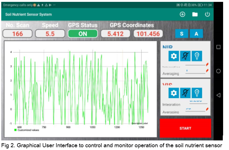
The soil nutrient sensor system comprises of visible and near infrared (Vis-NIR) spectrometers at the wavelength range of 350 to 1700nm, DGPS and soil penetrator that are embedded with optical fibre cables and probe. It is attached at the back of a tractor to ease its mobility across the field. The soil nutrient sensor system is equipped with graphical user interface software (Figure 2) which is installed in a tablet computer so that users can control and monitor the operation of the sensor remotely. The number of spectra scanned, GPS location, GPS status, tractor speed and spectra lines are displayed on the touch panel screen. The Start/Stop button is touched to start or stop the spectra acquisition task. The tablet computer communicates via WIFI connection with a rugged and robust personal computer that is installed with. This control module receives commands from the table computer and sends to the spectra acquisition system. All collected spectra data and GPS location are saved in this computer and the spectra line can be viewed in real-time through the tablet computer.
While the tractor is running on the field, the soil penetrator tip with a flat plane edge ensures uniform soil cuts and the soil flattener following behind forms a trench with a uniform underground surface. The Vis-NIR reflectance spectra of the underground soil (15 cm depth) are acquired automatically from the bottom of the trench and GPS location data are also recorded simultaneously. The collected Vis-NIR spectra are the input data to the developed models for calculation of the soil nutrient content (indigenous soil nutrient status) at specific location. The output from the calculation and GPS data are used to generate soil nutrient maps using the IDW interpolation method. The generated soil nutrient maps with fertilizer formulations and current crop nutrient status are then used to generate fertilizer treatment map at the corresponding specific location. This treatment maps can be used to guide the variable rate fertilizer applicator.
DECISION SUPPORT SYSTEM FOR MAPPING OF FERTILIZER REQUIREMENT RATE
In the map-based system, previous data is extensively used to build maps that depict distribution of soil variability and potential yield. Based on yield goals and economic constraints, decision support systems that utilize computer models/simulations help the farmer in preparing maps and software that allow them to supply seeds, fertilizers, irrigation, pesticides and other amendments, exactly to match, and overcome the variation (Krishna, 2013).
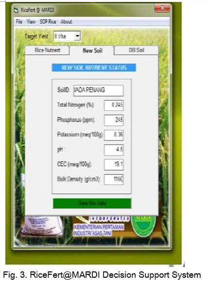
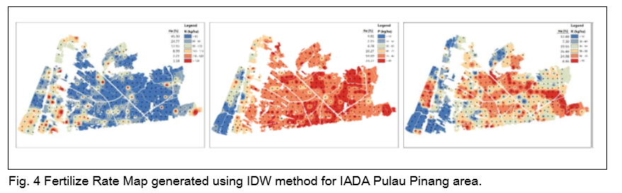
The newly decision support system (DSS) namely RiceFert@MARDI (Figure 3) has been developed by MARDI for calculating fertilizer requirement for paddy cultivation in Malaysia. The fertilizer requirement rate at specific location can then be translated into maps with the aid of geospatial technique (Theeba, et al., 2018; Zamir, et al., 2019). The input data for the RiceFert@MARDI formulation system comprise of point location, boundary, and native soil nutrient data. Standalone visual basic program will calculate all the input data simultaneously directly to produce the nutrient requirements and also the fertilizer formulations at specific location. The nutrient requirement rate is calculated based on Soil Test and Target Yield approach (Bera et al. 2006). Equation (1) is used to estimate the fertilizer rate. The output from the decision support system is translated into geodatabase environment to produce nutrient recommendation map as illustrated in Figure 4. Here, geospatial technique using Inverse Distance Weightage (IDW) interpolation takes place to produce maps for different nutrient requirement based on their adjacent point locations (Muhammad Zamir, et al. 2018). This is the process flow for paddy fertilizer rate module to be implemented for paddy granary fields at regional level. This technique is not only easily to understand, but also can generate new information for future reference.
Fertilizer dose = [Nutrient requirement (kg/t) of grain]/[CF (%)] × 100 × T (t/ha) − [CS (%)]/[CF (%)] × [Soil test value (kg/ha)] Eq. (1)
The RiceFert@MARDI formulation was verified at IADA Pulau Pinang, Seberang Jaya Selatan for main rice cropping season of 2017/2018. The verification was carried out at 3 ha plot for two target yield of 8 t/ha and 7 t/ha based on soil NPK and CEC status with control plots cultivated using current fertilizer subsidy rates. Rice crop growth data and yield analysis were carried out as an indicator for target yield achievement. Verification result demonstrated that the estimated site specific fertilizer rates were able to achieve 7.8 t/ha yield for selected location with targeted yield of 8 t/ha, and 7.03 t/ha yield for selected location with targeted yield of 7 t/ha.
CONCLUSION
Precision farming techniques requires a soil nutrient map of the field. It practically describes soil fertility variations and provides a rough guide for implementing agronomic procedures includes precision or location-specific fertilizer application. A soil nutrient map is also a good basis to improve yield production, reduce on fertilizers and manage nutrient dynamics appropriately. The use of Information and Communication Technologies (ICT) in agriculture has facilitated the generating of soil nutrient status and treatment maps for large scale paddy farming. This technology has been adopted for the establishment of improved technique of soil nutrient estimation and mapping. The decision support system RiceFert@MARDI has been developed for calculating nutrient requirement for paddy cultivation which then can be translated into maps with the aid of geospatial technique. This technique is aided with a soil nutrient sensor as an instrument for rapid assessment of soil nutrient status for large scale paddy farming.
REFERENCES
Bera, R., A. Seal, P. Bhattacharyya, T.H. Das, D. Sarkar, and K. Kangjoo, 2006. Targeted yield concept and a framework of fertilizer recommendation in irrigated rice domains of subtropical India, Journal of Zhejiang University Science, 7(12): 963–968. Blackmore, S., 2000. Developing the principles of Precision Farming. In ICETS 2000: Proceedings of the ICETS 2000 (China Agricultural University, Beijing, China), p. 11-13.
Fountas, S., M. Søren Pedersen and S. Blackmore, 2004. ICT in Precision Agriculture – diffusion of technology An overview of Precision Agriculture. Unpublished. https://doi.org/10.13140/2.1.1586.5606
Kodaira, M. and S. Shibusawa, 2013. Using a mobile real-time soil visible-near infrared sensor for high resolution soil property mapping. Geoderma, 199, 64 – 79.
Krishna, K.R., 2013. Precision Farming Soil Fertility and Productivity Aspects, Apple Academic Press, Inc.
Morellos, A., X.E. Pantazi, D. Moshou, T. Alexandridis, R. Whetton, G. Tziotzios, J. Wiebensohn, R. Bill and A. M. Mouazen, 2016. Machine learning based prediction of soil total nitrogen, organic carbon and moisture content by using VIS-NIR Spectroscopy, Biosystems Engineering Volume 152, 104-116.
Muhammad Zamir, A. R., I. Illani Zuraihah, M. Theeba, Z.Z. Nor Ziana, A.B. Noorsuhaila, F.R. Mohd Naim, M.Y. Mohd Najib, A. Hishamuddin, A.H. Asnita, M. Masni, M.S. Noranizam, 2018. Paddy Soil Nutrient Classification Using Geospatial Interpolation, 10th International Symposium on Plant-Soil Interactions at Low pH (PSILPH) 2018 June 25-28, 2018, Putrajaya, Malaysia
Muhammad Zamir, A. R., M. Theeba, R. Abdul Aziz, K. Hasliana, Z.Z. I. Norziana, Illani Zuraihah, F.R. Muhammad Naim, A. H. Asnita, T. Noor Mazirah, M.Masni, M. Noranizam, 2019. Site-Specific Nutrient Management for Paddy Fertilizer – System Design and Approach Soil Science Conference of Malaysia (SOILS 2019) 16th - 18th April 2019, Melaka, Malaysia.
National Research Council - Board on Agriculture, Committee on Assessing Crop Yield 1997. Precision Agriculture in the 21st Century: Geospatial and Information Technologies in Crop Management (National Academy Press, Washington, D.C., USA), p. 168.
Rajeev, R., A. Jha, R. K. Pal, and H.V. Vardhan Pauranik. 2013. Soil fertility mapping using GIS, GPS and for online fertilizer recommendation. Indian Journal Agriculture and Chemistry 15-28.
Theeba, M., I. Illani Zuraihah, A. R. Muhammad Zamir, Z. Z. Norziana, A. B. Norsuhaila, A. H. Nor Fadilah, F. R. Mohd Naim, M.Y. Mohd Najib, A. Hishamuddin, A.H. Asnita, , M. Masni, I. Khazanah, M.S. Noranizam, M.
S. Mohamad Zin, and T. Noor Mazirah, 2018. Location - Specific Fertilizer Management for Rice using Soil Test - Target Yield Approach. National Conference on Agricultural and Food Mechanization 2018. Kuching: MARDI. 1-6.
Vekic, T. T, I. Vladimir, B. Popovic, Z. Semialjac, D. Kerovec, and Z. Loncaric. 2017. "GIS Modelling of Site-Specific Fertilization Requirement." European Scientific Journal 70-80.

Soil Nutrient Estimation and Mapping for Precision Farming of Paddy in Malaysia
ABSTRACT
In precision farming, collection of information on spatial and temporal soil variability at high sampling resolution is essential for making precision agronomic decision based on maps such as the one for location-specific fertilizer application. This is to ensure the farmer potential to apply the exact requirement of nutrients at each given location in a field. The inability to obtain this information rapidly and inexpensively is however, one of the biggest limitations in precision agriculture. The Information and Communication Technologies (ICTs) need to be adopted to overcome this limitation. As one of the component in precision agriculture, ICTs have made the mapping of large amount of soil nutrient status and other soil characters for large field area are possible. This paper discusses the use of ICTs that have been adopted by the Malaysian Agricultural Research and Development Institute (MARDI) for the development of improved techniques for mapping of soil nutrient status and fertilizer requirement for precision fertilizer management in Malaysia.
Keywords: location-specific fertilizer management, precision farming, soil fertility, soil nutrient sensor, map-based nutrient assessment
INTRODUCTION
As soil naturally varies spatially and temporally due to various factors, acquisition of larger amounts of accurate soil nutrient data is necessary to achieve optimum yields towards meeting the food and demands of future populations. This data-driven farming by collecting, analyzing and correlating information about soil nutrient status, soil nutrient supplying capacity, fertilizer rate and potential yield in the respective location, will make farmers more informed decisions. It is important for this information to be presented on map for the purpose of visual display and analyzing spatial distribution of the available data whilst finding the causes for such pattern to occur (Vekic, et al. 2017). These maps help farmers in choosing suitable cropping pattern and agronomic procedures. It allows farmers to identify areas that need relatively less fertilizer, so that fertilizer cost can be minimized. Farmers can balance fertilizer supply with nutrient removal rates of different crops grown (Krishna, 2013). Moreover, nutrient maps prepared periodically provide farmers with an idea about the extent of soil degradation, loss or accumulation of nutrients and risks involved (Krishna, 2013) It also provides better understanding of the soil resources, and a good basis to improve yield, reduce on fertilizers and manage nutrient dynamics appropriately (Krishan, 2013). With systematic approach, tools such as fertilizer formulation, decision support system, geospatial technique, and crop modelling constitute a valuable system to facilitate farmers and decision makers in achieving higher yields and maximum return on investment from fertilizer being used (Ranjan, et al. 2013). However, farmers face many difficulties in efficiently managing the enormous amount of data they collect. They may lack sufficient time or are reluctant to invest the time needed to analyze the data and interpret the information (Fountas, 2004). For this reason, a wide range of techniques and technologies include information and communication technologies (ICTs) as well as sensor and application technologies has been implemented in precision agriculture.
The recent advances in information and telecommunication technologies (ICTs) have allowed farmers to acquire vast amounts of site-specific data for their fields, with the ultimate aim being to reduce uncertainty in decision-making (National Research Council, 1997; Blackmore, 2000). As one of the component in precision agriculture, ICTs have made the mapping of large amount of soil nutrient status and other soil characters for large field areas to be possible. Enormous amounts of accurate soil nutrient data can be collected, analyzed and correlated to obtain meaningful information to include distribution of soil fertility. This information is presented on soil nutrient maps that cover large paddy cultivation area for location-specific fertilizer application. This paper discusses the use of ICTs that have been adopted by the Malaysian Agricultural Research and Development Institute (MARDI) for the development of improved technique for mapping of soil nutrient status and fertilizer requirement for precision fertilizer management in Malaysia.
SOIL NUTRIENT SENSOR FOR SOIL NUTRIENT ASSESSMENT AND MAPPING
Precision agriculture practice requires soil information at much smaller scale for crop management and thus, data collection at high sampling resolution is needed (Morellos et al., 2016). A huge number of soil samples must be collected according to the many separate grids of a field or a crop compartment (Kodaira and Shibusawa 2013). The collection of a huge number of soil samples which then involves the laborious task of soil chemical analysis in the laboratory and require expert laboratory operator would simultaneously increases the cost and time (Bartholomeus et al., 2011; Ben-Dor and Demattê, 2015; Morellos et al., 2016). These limitations led to under-sampling, making it impractical for estimation soil fertility of large field areas for precision agriculture purposes. This type of limited sampling strategy makes it impossible to generate high-resolution map for establishment of management zones. Therefore, alternative measurement methods are needed to replace the conventional method for providing intensive information about soils at low cost, acceptable level of reliability and in a timely manner. For these reasons a soil nutrient sensor system has been developed by MARDI (Figure 1) for measurement and mapping of paddy soil nutrient such as N, P, K, pH and CEC.
The soil nutrient sensor system comprises of visible and near infrared (Vis-NIR) spectrometers at the wavelength range of 350 to 1700nm, DGPS and soil penetrator that are embedded with optical fibre cables and probe. It is attached at the back of a tractor to ease its mobility across the field. The soil nutrient sensor system is equipped with graphical user interface software (Figure 2) which is installed in a tablet computer so that users can control and monitor the operation of the sensor remotely. The number of spectra scanned, GPS location, GPS status, tractor speed and spectra lines are displayed on the touch panel screen. The Start/Stop button is touched to start or stop the spectra acquisition task. The tablet computer communicates via WIFI connection with a rugged and robust personal computer that is installed with. This control module receives commands from the table computer and sends to the spectra acquisition system. All collected spectra data and GPS location are saved in this computer and the spectra line can be viewed in real-time through the tablet computer.
While the tractor is running on the field, the soil penetrator tip with a flat plane edge ensures uniform soil cuts and the soil flattener following behind forms a trench with a uniform underground surface. The Vis-NIR reflectance spectra of the underground soil (15 cm depth) are acquired automatically from the bottom of the trench and GPS location data are also recorded simultaneously. The collected Vis-NIR spectra are the input data to the developed models for calculation of the soil nutrient content (indigenous soil nutrient status) at specific location. The output from the calculation and GPS data are used to generate soil nutrient maps using the IDW interpolation method. The generated soil nutrient maps with fertilizer formulations and current crop nutrient status are then used to generate fertilizer treatment map at the corresponding specific location. This treatment maps can be used to guide the variable rate fertilizer applicator.
DECISION SUPPORT SYSTEM FOR MAPPING OF FERTILIZER REQUIREMENT RATE
In the map-based system, previous data is extensively used to build maps that depict distribution of soil variability and potential yield. Based on yield goals and economic constraints, decision support systems that utilize computer models/simulations help the farmer in preparing maps and software that allow them to supply seeds, fertilizers, irrigation, pesticides and other amendments, exactly to match, and overcome the variation (Krishna, 2013).
The newly decision support system (DSS) namely RiceFert@MARDI (Figure 3) has been developed by MARDI for calculating fertilizer requirement for paddy cultivation in Malaysia. The fertilizer requirement rate at specific location can then be translated into maps with the aid of geospatial technique (Theeba, et al., 2018; Zamir, et al., 2019). The input data for the RiceFert@MARDI formulation system comprise of point location, boundary, and native soil nutrient data. Standalone visual basic program will calculate all the input data simultaneously directly to produce the nutrient requirements and also the fertilizer formulations at specific location. The nutrient requirement rate is calculated based on Soil Test and Target Yield approach (Bera et al. 2006). Equation (1) is used to estimate the fertilizer rate. The output from the decision support system is translated into geodatabase environment to produce nutrient recommendation map as illustrated in Figure 4. Here, geospatial technique using Inverse Distance Weightage (IDW) interpolation takes place to produce maps for different nutrient requirement based on their adjacent point locations (Muhammad Zamir, et al. 2018). This is the process flow for paddy fertilizer rate module to be implemented for paddy granary fields at regional level. This technique is not only easily to understand, but also can generate new information for future reference.
Fertilizer dose = [Nutrient requirement (kg/t) of grain]/[CF (%)] × 100 × T (t/ha) − [CS (%)]/[CF (%)] × [Soil test value (kg/ha)] Eq. (1)
The RiceFert@MARDI formulation was verified at IADA Pulau Pinang, Seberang Jaya Selatan for main rice cropping season of 2017/2018. The verification was carried out at 3 ha plot for two target yield of 8 t/ha and 7 t/ha based on soil NPK and CEC status with control plots cultivated using current fertilizer subsidy rates. Rice crop growth data and yield analysis were carried out as an indicator for target yield achievement. Verification result demonstrated that the estimated site specific fertilizer rates were able to achieve 7.8 t/ha yield for selected location with targeted yield of 8 t/ha, and 7.03 t/ha yield for selected location with targeted yield of 7 t/ha.
CONCLUSION
Precision farming techniques requires a soil nutrient map of the field. It practically describes soil fertility variations and provides a rough guide for implementing agronomic procedures includes precision or location-specific fertilizer application. A soil nutrient map is also a good basis to improve yield production, reduce on fertilizers and manage nutrient dynamics appropriately. The use of Information and Communication Technologies (ICT) in agriculture has facilitated the generating of soil nutrient status and treatment maps for large scale paddy farming. This technology has been adopted for the establishment of improved technique of soil nutrient estimation and mapping. The decision support system RiceFert@MARDI has been developed for calculating nutrient requirement for paddy cultivation which then can be translated into maps with the aid of geospatial technique. This technique is aided with a soil nutrient sensor as an instrument for rapid assessment of soil nutrient status for large scale paddy farming.
REFERENCES
Bera, R., A. Seal, P. Bhattacharyya, T.H. Das, D. Sarkar, and K. Kangjoo, 2006. Targeted yield concept and a framework of fertilizer recommendation in irrigated rice domains of subtropical India, Journal of Zhejiang University Science, 7(12): 963–968. Blackmore, S., 2000. Developing the principles of Precision Farming. In ICETS 2000: Proceedings of the ICETS 2000 (China Agricultural University, Beijing, China), p. 11-13.
Fountas, S., M. Søren Pedersen and S. Blackmore, 2004. ICT in Precision Agriculture – diffusion of technology An overview of Precision Agriculture. Unpublished. https://doi.org/10.13140/2.1.1586.5606
Kodaira, M. and S. Shibusawa, 2013. Using a mobile real-time soil visible-near infrared sensor for high resolution soil property mapping. Geoderma, 199, 64 – 79.
Krishna, K.R., 2013. Precision Farming Soil Fertility and Productivity Aspects, Apple Academic Press, Inc.
Morellos, A., X.E. Pantazi, D. Moshou, T. Alexandridis, R. Whetton, G. Tziotzios, J. Wiebensohn, R. Bill and A. M. Mouazen, 2016. Machine learning based prediction of soil total nitrogen, organic carbon and moisture content by using VIS-NIR Spectroscopy, Biosystems Engineering Volume 152, 104-116.
Muhammad Zamir, A. R., I. Illani Zuraihah, M. Theeba, Z.Z. Nor Ziana, A.B. Noorsuhaila, F.R. Mohd Naim, M.Y. Mohd Najib, A. Hishamuddin, A.H. Asnita, M. Masni, M.S. Noranizam, 2018. Paddy Soil Nutrient Classification Using Geospatial Interpolation, 10th International Symposium on Plant-Soil Interactions at Low pH (PSILPH) 2018 June 25-28, 2018, Putrajaya, Malaysia
Muhammad Zamir, A. R., M. Theeba, R. Abdul Aziz, K. Hasliana, Z.Z. I. Norziana, Illani Zuraihah, F.R. Muhammad Naim, A. H. Asnita, T. Noor Mazirah, M.Masni, M. Noranizam, 2019. Site-Specific Nutrient Management for Paddy Fertilizer – System Design and Approach Soil Science Conference of Malaysia (SOILS 2019) 16th - 18th April 2019, Melaka, Malaysia.
National Research Council - Board on Agriculture, Committee on Assessing Crop Yield 1997. Precision Agriculture in the 21st Century: Geospatial and Information Technologies in Crop Management (National Academy Press, Washington, D.C., USA), p. 168.
Rajeev, R., A. Jha, R. K. Pal, and H.V. Vardhan Pauranik. 2013. Soil fertility mapping using GIS, GPS and for online fertilizer recommendation. Indian Journal Agriculture and Chemistry 15-28.
Theeba, M., I. Illani Zuraihah, A. R. Muhammad Zamir, Z. Z. Norziana, A. B. Norsuhaila, A. H. Nor Fadilah, F. R. Mohd Naim, M.Y. Mohd Najib, A. Hishamuddin, A.H. Asnita, , M. Masni, I. Khazanah, M.S. Noranizam, M.
S. Mohamad Zin, and T. Noor Mazirah, 2018. Location - Specific Fertilizer Management for Rice using Soil Test - Target Yield Approach. National Conference on Agricultural and Food Mechanization 2018. Kuching: MARDI. 1-6.
Vekic, T. T, I. Vladimir, B. Popovic, Z. Semialjac, D. Kerovec, and Z. Loncaric. 2017. "GIS Modelling of Site-Specific Fertilization Requirement." European Scientific Journal 70-80.