ABSTRACT
The relocation of the national capital is an old issue in Indonesia and has only been realized during the current government administration. It will certainly have positive and negative impacts, including on the agricultural sector. The purpose of this paper is to analyze the planning and implementation of capital city development and its implications for the agricultural sector. The Capital City of the Nusantara (IKN) is the name of the new capital city of Indonesia which will be built on an area of 256,142 hectares of land area and 68,188 hectares of water area in East Kalimantan province. It is expected that the national development could be evenly distributed, particularly in the eastern region of Indonesia, bearing in mind that the epicenter of the nation’s capital is in the middle of the country. Currently, the construction of the IKN is still in the early stages with a concentration on the planning area of the central government core area. It is planned that the construction will be completed by 2045. The implications for the agricultural sector are especially in the allocation of agricultural land as a fundamental infrastructure for agricultural development. The issued regulations have provided good protection for agricultural development. It is recommended to complement the IKN development toward sustainable food agricultural land and standard area of rice field programs.
Keywords: Nusantara Capital City (IKN), spatial plan, agricultural land, East Kalimantan
INTRODUCTION
The capital city of Indonesia is Jakarta. This city became the center of government along with the proclamation of Indonesian independence on 17 August 1945. Due to security reasons in the early days of independence, the capital was relocated to several locations. First, it relocated to Yogyakarta in Central Java (from 4 January 1946 to 18 December 1948). Second, to Bukittinggi in West Sumatra (from 19 December 1948 to 26 December 1949). Third, be returned to Yogyakarta (from 27 December 1949 to 16 August 1950). From 17 August 1950 up to the present, the capital city of Indonesia is Jakarta (IMoCI, 2022).
Considering that Jakarta is increasingly congested with all its complications, the Indonesian government plans to relocate the capital city to another location. Initially, the idea was first made by the first president of Indonesia on 17 July 1957. Palangkaraya, located in Central Kalimantan, was selected since its position is in the middle of the country with a vast territory. However, the idea was never implemented; the government even confirmed Jakarta as the national capital based on Law Number 10/1964. Furthermore, during the new order era, the relocation of the national capital was planned, namely to the Jonggol area, Bogor regency, West Java province. However, the plan failed to be implemented. The plan for the arrangement of the state capital re-appeared in the era of the sixth president (2014-2024). There were three options, namely: (1) Keep Jakarta as the center of government by making improvements; (2) Keep Jakarta as the national capital but the center of government relocates to another area; and (3) Establish a new national capital. Again, this plan failed to be realized. Eventually, the idea of moving the national capital was realized under the National Medium-Term Development Plan (RPJMN) 2020-2024 (GoI, 2020).
The development of the Indonesian state capital was set for 29 April 2019. It requires a large-scale budget from domestic and foreign investments. Based on the directive of the president in 2019, the contribution of the state budget is only 19%. The development process was delayed due to the impact of COVID-19 in early 2020. After the government declared an end to the national emergency status of the pandemic, state capital development was started. It was supported by Law Number 3/2022 on State Capital based on the motivated spirit of improving the governance as part of efforts to realize the goals of the state through relocating the national capital from Jakarta to East Kalimantan province. It was noted the state capital named Nusantara referred to as the Archipelago capital and formally known as “IKN” stands for Ibu Kota Nasional Nusantara/Nusantara Capital City (GoI, 2022a).
The relocation of the national capital will have an impact on shifting the concentration of the population and regional economic development. The derivative impact will be felt by all government sectors including agriculture. Infrastructure and facilities such as land availabilities, irrigation networks, and environmental changes are major issues that will affect agricultural development in affected areas. It is questionable. First, how does the development plan for the national capital concern the agricultural sector, and how the impact will be felt by the agricultural sector as a result of the development of the national capital? Second, how would the impact be felt by the agricultural sector as a result of the development of the national capital?
Based on the above questions, this paper proposes to formulate alternative policies for the development of the agricultural sector in the IKN of Indonesia. In more detail, the paper deliberates the following parts: (1) Discussing the strategic plan and development of IKN; (2) Analyzing the IKN development in the agricultural sector; and (3) Formulating policy recommendations for improving agricultural plans and programs in IKN.
STRATEGIC PLAN AND DEVELOPMENT
Rationale
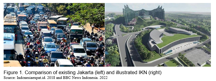
In any hemisphere, the capital of a country always grows and develops rapidly, including Jakarta. This city has experienced growth and development following a significant development path. Jakarta is not only the center of state government but also a trade (business) hub. Nevertheless, Jakarta faces a complexity of problems from both technical and socioeconomic aspects primarily caused by the increasing population and incessant development (Iqbal, 2017). Therefore the relocation of the national capital from Jakarta to another representative area is a logical consequence of overcoming this problem. The comparison of existing Jakarta and illustrated IKN can be seen in Figure 1.
The relocation of the national capital has a high level of urgency. There are at least two basic important things that must be considered. It includes:
- The relocation of the national capital from Jakarta to other regions is caused by certain reasons (Andjarwati, 2019). First, there is a development gap between the western and eastern regions. The required Indonesian capital city is geographically in the middle of Indonesia's territory because the middle region represents justice and encourages the acceleration of development, especially for the eastern region of Indonesia (encouraging an Indonesia-centric capital city). Second, Jakarta is prone to earthquakes since it is located in the ring of fire. Third, congested, crowded, and dirty (Jakarta is the fourth worst city out of 390 cities in the world, based on busy traffic conditions). Fourth, communication and coordination between ministries and institutions are sometimes ineffective. As a result, there was an economic loss of Rp56 trillion (US$4.13 billion) per year in 2013. It is estimated that with increasing congestion in the Jakarta area as of April 2019, losses would be close to Rp100 trillion (US$7.19 billion) per year. Fifth, the flood-prone problem starts from the upstream, subsidence of the land surface on the north coast of Jakarta, and rising sea levels. Sixth, about 96% of the quality of river water in Jakarta is heavily polluted. Seventh, It is required the new capital city that reflects national identity, modern, and international class (smart, green, and beautiful city).
- The actual condition of Jakarta is increasingly burdensome, including: (a) The high population density i.e., 15,978 people per km2 in 2021, or much higher as compared to the national population density of 142 people per km2 (CBS, 2023); (b) The high extent of congestion, namely the 29th most congested city in the world out of 390 big cities in 56 countries in 2022. The average time needed to travel 10 kilometers in Jakarta is 22 minutes 40 seconds so the average speed is only 22 kilometers per hour. This city has 214 rush hours per year (Tom Tom Traffic Index, 2023); and (c) Environmental and geological issues particularly floods that hit Jakarta almost every month (LDMA, 2023) and land subsidence which has resulted in parts of Jakarta being below sea level such as in the northern region of Jakarta (IMoPWH, 2023).
The new state capital must encourage inclusive and equitable economic growth, including in the Eastern part of Indonesia. So far, Jakarta and its surrounding areas have been the center of government, politics, industry, trade, investment, technology, culture, and others. It was noted that the circulation of money in Jakarta reaches 70%, which covers only 664.01 square kilometers (km2) or 0.003% of Indonesia’s total land area of 1,919,440 km² (Nainggolan, 2022). Meanwhile, the population of this city in 2020 was 10.56 million people, or about 3.9% of Indonesia’s population of 270.20 million (CBS, 2023). The new state capital is located in East Kalimantan and is expected to become the “center of gravity” of the new economy in Indonesia, especially in the central and eastern regions of Indonesia. It is also alleged to create new centers of economic growth and maximize regional potential resources.
Scope of the development plan
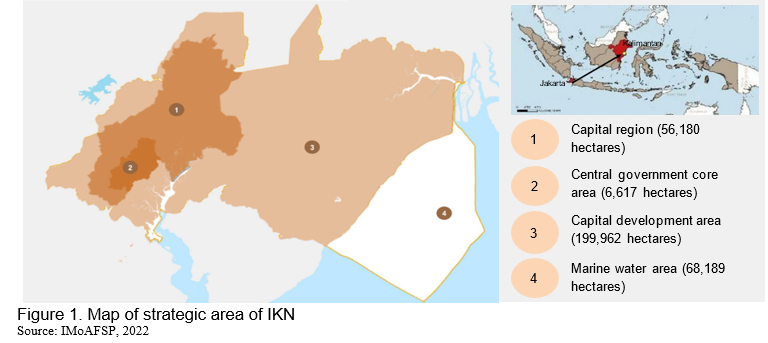
The strategic area of IKN will be developed in the area of 324,332 hectares comprising 256,142 hectares of land area and 68,188 hectares of water area. This land area is divided into the IKN area (62,851 hectares) and the developed IKN area (199,962 hectares) including 6,671 hectares of the central government core area (Figure 1).
Delineated area
There are 54 existing villages at IKN delineation in seven sub-districts of two districts. It includes: (1) 15 villages in Sepaku sub-districts of North Penajam Paser districts; and (2) 22 villages in Samboja sub-district, seven villages in Muara Jawa sub-district, five villages in Loa Janan sub-district, three villages in Loa Kulu sub-district, and one village in Sangasanga sub-district of Kutai Kartanegara district (Figure 2).
Planning area
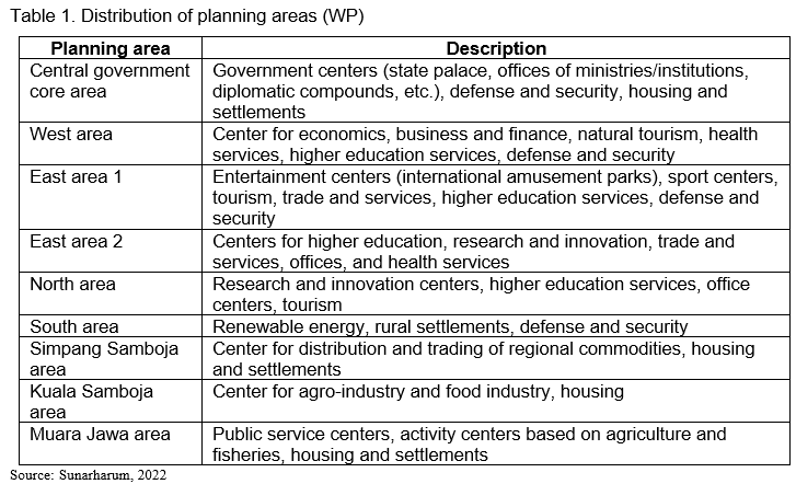
The development of IKN will be divided into nine plan areas comprising six Planning Areas i.e., Central government Core Area, West Area, East Area 1, East Area 2, North Area, and South Area), followed by three Planning Areas i.e., Simpang Samboja Area, Kuala Samboja Area, and Muara Jawa Area (Table 1 and Figure 2). The determination of the detailed spatial plan areas has been carried out based on the Regulation of the Head of the IKN Authority. It covers four Plan Areas (Central Government Core Area, West Area, East Area 1, and East Area 2). The rest will be conducted immediately, in which the technical material requirements have been completed by the Ministry of Agrarian Affairs and Spatial Planning/National Land Agency and Geospatial Information Agency validated by the Ministry of Environment and Forestry (Yofa et al., 2023).
Spatial plan
The development of IKN is planned to become “Smart and Sustainable Forest Cities.” It comprises green areas of 256,142 hectares comprising protected areas of 173,526 hectares (67.75%) and a cultivation area of 82,617 hectares (32.25%). Protected areas consist of water body areas, locally protected areas, protected forest areas, grand forest park areas, mangrove ecosystem areas, urban forest areas, city park areas, district park areas, village park areas, cemetery areas, and green belt areas. Meanwhile, the cultivation area consists of mixed areas i.e., road body areas, public and social facility areas, office infrastructure areas, tourism areas, power generation areas, trade and service areas, aquaculture areas, office areas, defense and security areas, residential areas, and industrial designation areas (GoI, 2022b).
Development implementation
Currently, the government focuses on the development of the central government core area comprising presidential and vice presidential palaces, parliament building, ministry/agency buildings, city service centers, as well as housing and settlements. Apart from that, the Sepaku Semoi Dam has also been built with a water flow rate of 2,500 liters per second, the Intake Sepaku Building with a water flow rate of 3,000 liters per second, and the construction of a toll road for access to and from IKN (Yofa et al., 2023).
Population migration
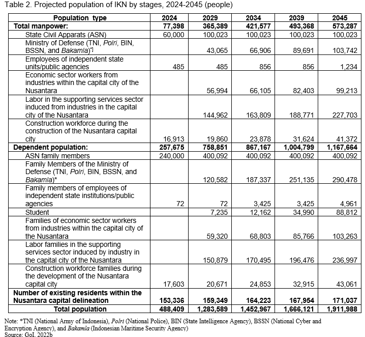
The IKN has been projected to be occupied by population based on Presidential Regulation Number 63/2022 (GoI, 2022b). It consists of three groups i.e., workforce, dependent population, and existing residents who are within the delineation of the IKN. The workforce includes government employees, Ministry of Defense employees including the National Army (TNI) and National Police (Polri), employees of independent state institutions, workers in the economic sector, workers in the supporting services sector, and construction workers during the IKN construction period. Service sector workers will take up the largest portion of the total workforce, and in general workers who migrate to the IKN and their dependents will be the largest population in 2045 who occupy the IKN area compared to the existing population. In detail, the stages of population migration can be seen in Table 2.
Development budget
It was noted that the development budget for IKN is still relying on the state budget (APBN). Up to the present, there is no supported budget either from domestic or foreign investments (CNBC Indonesia, 2023).
Land transaction
On February 14, 2022, the Head of the National Land Agency (BPN) of East Kalimantan province issued a circular letter on establishing a moratorium on purchasing and selling lands in the IKN area. This was to prevent illegal land buying and selling transactions, especially toward land speculators who can make uncontrollable prices of lands. For parties who are forced to purchase and sell lands, BPN will not take care of the administration so the transfer of land rights to the transacting party is not recognized (CNN Indonesia, 2023).
There is a weakness in this issue since this essential matter has been merely determined by a circular letter. In other words, there are no legal consequences for the parties who will violate it. On the contrary, if the issue is determined by law, there will be legal consequences for those who violate it. The violating parties expect that legal documents will be taken care of after the moratorium on land sales is lifted.
AGRICULTURAL DEVELOPMENT
Agricultural land allocation
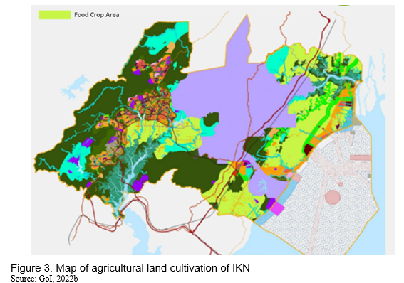
IKN will allocate 42,003 hectares for agricultural cultivation, or about 16.45% of the total IKN area. With a large portion of green areas, it is expected that IKN will become a beautiful national capital and have substantial food production. Determination of the allocation of food agricultural land has been set by the detailed spatial plan area. It initially includes 9,485 hectares (22,58%) comprising the West Planning Area (2,096 hectares), South Planning Area (13 hectares), East Planning Area (3,084 hectares), Simpang Samboja Planning Area (1,456 hectares), Kuala Samboja Planning Area (618 hectares), and Muara Jawa Planning Area (2,218 hectares). Yet, 32,518 hectares (77.42%) of agricultural land have not been determined to support the environment and food security of the IKN (Figure 3).
Food crop agriculture
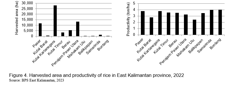
Rice is the main source of carbohydrates consumed by communities in East Kalimantan province. As much as 46% of rice production in this province comes from the Kutai Kartanegara district with a central producing area in Tenggarong sub-district. Rice production in Paser and North Penajam Paser districts contributes respectively 19% and 18% of total rice production in East Kalimantan. The central producing areas of rice in Paser district are Long Kali, Pasir Belengkong, and Long Ikis sub-districts. Meanwhile, the central producing area of rice in North Penajam Paser district is Babulu sub-district. These central producing areas are closely located to the IKN area; therefore, it is expected that the IKN development will not have an impact on reducing the rice area toward declining in rice production.
Rice productivity in East Kalimantan is around 3.63 tons per hectare. The highest productivity was in Bontang city (3.96 tons/ha) and the lowest productivity was in Mahakam Hulu district (2.43 tons/ha). These productivities were below than the national productivity i.e., 6.28 tons per hectare (Indonesia.go.id, 2022). Many farmers still plant local varieties with low productivity within one planting season a year (5-6 months to harvest after planting). The harvested area and productivity of rice in East Kalimantan province can be seen in Figure 4.
North Penajam Paser and Kutai Kartanegara districts, which support food production in IKN, still have potential land that can be utilized. Husnain (2022) explains that one of the commodities that can be developed in these two regions is rice. Land that can be used for agricultural cultivation is ex-mining land. However, there is a challenge since the soil nutrient content in ex-mining land is very minimal. Therefore, certain treatments need to be carried out to restore soil nutrients. Returning soil nutrients can be carried out, for example, by tilling the soil, liming, applying manure before planting, and using fertilizer after planting.
POLICY SUPPORT
The development of IKN is based on several laws and regulations. They are: (1) Law Number 3/2022 concerning the State Capital; (2) Government Regulation Number 17/2022 concerning Funding and Budget Management in the Context of Preparation, Development and Transfer of the National Capital and Administration of IKN, (3) Presidential Regulation Number 63/2022 concerning Details Master Plan of IKN; (4) Presidential Regulation Number 62/2022 concerning the IKN; (5) Presidential Regulation Number 64/2022 concerning the Spatial Plan for the National Strategic Area of IKN in 2022-2042; (6) Presidential Regulation Number 65/2022 concerning Land Acquisition and Management of Land in IKN; and (7) Regulation of the Head of IKN Authority Number 1/2022 concerning the Organization and Work Procedure of the IKN Authority (Sunarharum, 2022).
Programs and provisions for the development of the agricultural sector in the IKN area are regulated in Presidential Regulation Number 64/2022 (GoI, 2022b). It was organized as follows:
- The main programs of agriculture in the IKN comprise: (a) Preservation of technical irrigated rice fields; (b) Development of agricultural facilities and infrastructure; (c) Determination of sustainable food agricultural land; (d) Provision of incentives and disincentives for owners of sustainable food agricultural land; and (e) Rehabilitation, revitalization, and arrangement of agricultural land.
- The general provisions for zoning food crop areas are:
- Permitted activities for food crops, horticulture, estate crops, livestock, and irrigation facilities;
- Conditionally permitted activities for large-scale agricultural land, wetland, dryland, irrigation, surface water development, agriculture-based tourism; agricultural education and research, and low-density housing that supports agriculture, estate crops, livestock, and irrigation facilities development;
- Non-permitted activities that damage the irrigation network system, reduce the area of agricultural areas, and are not following the allotment of agricultural areas;
- The intensity of space utilization meets a minimum green base coefficient of 80%, a maximum basic building coefficient of 20%, and a maximum building floor coefficient of 0.4;
- Minimum requirements to support the development facilities for local scale agricultural agro-industry as well as basic facilities and infrastructure supporting agricultural areas; and
- Another directive provision i.e., large-scale agricultural activities must first have an environmental impact analysis study.
- The special provision for sustainable food agricultural land: (a) Protection from land conversion; (b) Determination based-detailed spatial plan; (c) Development through intensification of agricultural land; and (d) Development to support infrastructure for agriculture and ecotourism.
On the one hand, the concept of developing IKN which is environmentally friendly and highly supportive of agricultural development has not been fully implemented. On the other hand, the fulfillment of food needs to be continued. Moreover, the local budget for supporting agricultural activities is very limited considering that these areas are no longer under the authority of the local government. With the increase in the number of residents in the IKN area of around 15,000 people who are development project workers, the level of food prices has increased. An increase in food prices is an indication of a reduction in food availability relative to an increase in demand. It is expected that the same thing will happen when the number of migrations of people entering the IKN increases as projected in Presidential Decree Number 63/2022. As a result, there is a need to speed up the food supply process in line with the development of IKN.
CONCLUSION AND RECOMMENDATIONS
Conclusion
Jakarta as the capital city has been recognized as the political, economic, and cultural heart of Indonesia. However, due to various challenges faced by this city such as overpopulation, environmental issues, and congestion, the government has decided to relocate the capital city to a new location in East Kalimantan province known as “Nusantara Capital City (IKN)” This decision aims to create a more sustainable and suitable administrative center for the nation.
Up to the present, the development of IKN is still concentrating on the central government core area including the state palace, parliament building, ministry and institution buildings, and other basic infrastructures. The development will last until 2045 by completing other planning areas. The regulations that have been set are very in favor of agricultural development. With the tagline “Smart and Green Cities” protection of agricultural land can be considered as the government’s top priority. Policies on the use of agricultural land are regulated very well, namely through the provisions of permitted, conditionally permitted, and non-permitted activities for agriculture.
Above all, there are challenges and opportunities associated with the relocation of the capital city, particularly in terms of environmental sustainability. Effective planning and implementation can help in maximizing the benefits for the agricultural sector while minimizing potential negative impacts.
Recommendations
It is recommended that the general policies that have been set for the agricultural sector in the IKN area should be implemented based on the following issues:
- Mapping the suitability of land for both agricultural and non-agricultural purposes. It should be mainly carried out on lands in environmental buffer zones and food security which is the most extensive area in the entire mainland of the IKN;
- Ground checking in detail based on mapping results to ensure that the map has been made suitable for field conditions;
- Determining the results of the mapping that has been carried out by the ground check in the regulatory documents. It is the authority of the Head of IKN to determine the Detailed Spatial Plan assisted by the National Land Agency;
- Establishing the sustainable food agricultural land and the standard area of paddy fields in the detailed spatial plan. At least, this shall contain the area and spatial position; and
- Complementing the use of agricultural land following its provisions in the forms of a detailed spatial plan, sustainable food agricultural land, and the standard area of rice fields.
It should be underlined that the implications development of IKN for the agricultural sector will depend upon a variety of factors, including the specific characteristics of the IKN area, the government’s policies, the pace of development, and how various challenges are addressed. Moreover, there will be challenges with some technical and non-technical aspects such as land speculation, land use changes, water and resource management, environmental concerns, technological adoption, infrastructure connectivity development, economic opportunities, market access, research and development, policy focus and shifts, urbanization pressure, displacement of farmers, pressure on local resources, migration patterns, and cultural changes. Hence, balancing urban development with the needs of the agricultural sector and local communities will be a key challenge for the Indonesian government to ensure sustainable development in the respected area.
REFERENCES
Andjarwati, A. 2019. Pemindahan Ibu Kota Negara dalam Perspektif Hukum Agraria dan Administrasi Negara (Relocation of the State Capital in the Perspective of Agrarian and State Administration Laws). Gadjah Mada Univerisity. Yogyakarta.
Bappenas. 2020. Naskah Akademik Rancangan Undang-Undang tentang Ibu Kota Negara (Academic Script of the Draft Law on the State Capital). Kementerian Perencanaan Pembangunan Nasional Republik Indonesia/Badan Perencanaan Pembangunan Nasional (Indonesian Ministry of National Development Planning/National Development Planning Agency). Jakarta.
BBC News Indonesia. 2022. IKN Nusantara: Siapa yang Mendanai Pembangunan Ibu Kota Baru? (IKN Nusantara: Who is funding the construction of the new capital city?). Retrieved from: https://www.bbc.com/indonesia /articles/cpd17vpr8kjo (12 August 2023).
BPS Kaltim. 2023. Provinsi Kalimantan Timur Dalam Angka 2023 (East Kalimantan Province in Figures 2023). Badan Pusat Statistik (Central Bureau of Statistics) of East Kalimantan Province. Samarinda.
CBS. 2023. Jumlah dan Distribusi Penduduk (Number and Distribution of Population). Retrieved from: https://sensus.bps.go.id/main/index/sp2020#:~:text=Jumlah%20penduduk%20I... (10 August 2023).
CNBC Indonesia. 2023. Kepala OIKN: Investor Swasta Mulai Bangun IKN di November ini (Head of OIKN: Private Investors Start Building IKN this November). Retrieved from: https://www.cnbcindonesia.com/news/ 20230918141337-4-473393/kepala-oikn-investor-swasta-mulai-bangun-ikn-di-november-ini (20 September 2023).
CNN Indonesia. 2023. Kementerian ATR/BPN Ungkap Jual Beli Tanah Masih Terjadi di IKN (Ministry of ATR/BPN Reveals Land Buying and Selling Still Happening at IKN). Retrieved from: https://www.cnnindonesia.com/ekonomi/20230522140929-92-952445/kementerian-atr-bpn-ungkap-jual-beli-tanah-masih-terjadi-di-ikn (20 September 2023).
GoI. 2020. Rencana Pembangunan Jangka Menengah Nasional 2020-2024 (National Medium Term Development Plan 2020-2024). Government of Indonesia. Jakarta.
GoI. 2022a. Undang-Undang Nomor 3 Tahun 2022 tentang Ibu Kota Negara (Law Number 3 of 2022 concerning the State Capital). Government of Indoesia. Jakarta.
GoI. 2022b. Peraturan Presiden Republik Indonesia Nomor 63 Tahun 2022 tentang Perincian Rencana Induk Ibu Kota Nusantara (Indonesian President Regulation Number 63/2022 concerning Details of the Nusantara Capital City Master Plan). Government of Indonesia. Jakarta.
GoI. 2022c. Peraturan Kepala Otorita Ibu Kota Nusantara Republik Indonesia Nomor 1 Tahun 2022 tentang Organisasi dan Tata Kerja Otorita Ibu Kota Nusantara (Regulation of the Head of the Nusantara Capital Authority of the Republic of Indonesia Number 1/2022 concerning the Organization and Work Procedure of the Nusantara Capital Authority). Government of Indonesia. Jakarta.
Husnain. 2022. Kajian Kesesuaian Lahan pada Kawasan Tanaman Pangan di Kawasan Strategis Nasional Ibu Kota Nusantara (Land Suitability Study in Food Crop Areas in the National Strategic Area of the Capital Region of Nusantara). Meeting Material. Bogor, February 3, 2023.
IMoAFSP. 2022. Kawasan Pertanian dalam Rencana Tata Ruang Ibu Kota Nusantara (Agricultural Areas in the Nusantara Capital Spatial Plan). Meeting Material, 11 November 2022. Indonesian Minister of Agrarian Affairs and Spatial Planning. Jakarta.
IMoCI. 2022. Perjalanan Perpindahan Ibu Kota Indonesia (Migration Journey of the Indonesian Capital City). Retrieved from: https://indonesiabaik.id/infografis/perjalanan-perpindahan-ibu-kota-indonesia (9 August 2023). Jakarta. Indonesian Ministry of Communications and Informatics. Jakarta.
IMoPWH. 2023. Atasi Laju Penurunan Permukaan Tanah DKI Jakarta, Kementerian PUPR Siapkan Langkah Quick Wins (To Overcome DKI Jakarta’s Land Subsidence Rate, Ministry of PUPR Prepares Quick Wins Steps). Retrieved from: https://pu.go.id/berita/atasi-laju-penurunan-permukaan-tanah-dki-jakarta-kementerian-pupr-siapkan-langkah-quick-wins (10 August 2023). Indonesian Ministry of Public Works and Housing. Jakarta.
Indonesia.go.id. 2022. Produksi Padi di 2022 Alami Kenaikan (Increase in Rice Production in 2022). Retrieved from: https://indonesia.go.id/kategori/editorial/6142/produksi-padi-di-2022-alami-kenaikan?lang=1#:~:text= Sejalan% 20dengan%20peningkatan%20luas%20panen,0%2C43%25%20dibanding%202021 (22 September 2023)
Indonesiaexpat.id. 2018. Jakarta Ranked as 12th Worst Congested City in the World. Retrieved from: https://indonesiaexpat.id/featured/jakarta-ranked-12th-worst-congested-c... (12 August 2023). Jakarta.
Iqbal, M. 2017. Wacana Pemindahan Ibukota ke Palangkaraya (Discourse on Moving the Capital City to Palangkaraya). Majalah Catra. Edisi VIII: 4-5. April 2017. Sekretariat Jenderal Dewan Katahanan Nasional (Indonesian Secretariat General of the National Resilience Council). Jakarta.
LDMA. 2023. Infografis Kejadian Bencana Provinsi DKI Jakarta Tahun 2022 (Infographic of DKI Jakarta Province Disaster Events in 2022). Retrieved from: https://bpbd.jakarta.go.id/perpustakaan/180/ infografis-kejadian-bencana-2022. Local Disaster Management Agency. Jakarta.
Nainggolan E. U. P. 2022. Urgensi Pemindahan Ibu Kota Negara (The Urgency of Relocating the National Capital) Retrieved from: https://www.djkn.kemenkeu.go.id/kanwil-kalbar/baca-artikel/14671/Urgensi-Pemindahan-Ibu-Kota-Negara.html (10 August 2023)
Sunarharum, T. M. 2022. Perencanaan Pembangunan Ibu Kota Nusantara (Planning for the Development of the Capital City of the Nusantara). Webinar Nasional “Aspek Penting Mitigasi Bencana dalam Perencanaan Ibu Kota Nusantara” (National Webinar “Important Aspects of Disaster Mitigation in Planning for the Nusantara’s Capital City”). 19 November 2022.
Tom Tom Traffic Index. 2023. Ranking 2022. Retrieved from: https://www.tomtom.com/traffic-index/ranking/ (10 August, 2023).
Yofa R.D., A. R. Irawan, W. F. Setyaningrum, J. Mulyono, and K. S. Septanti. 2023. Kajian Kecukupan dan Pasokan Pangan Ibu Kota Negara Baru (Study of Sufficiency and Food Supply in the New Capital City). Policy Analysis Report. Indonesian Center for Agricultural Socio Economic and Policy Studies. Bogor.


The Development of Indonesian New State Capital (IKN) and Its Implications for the Agricultural Sector
ABSTRACT
The relocation of the national capital is an old issue in Indonesia and has only been realized during the current government administration. It will certainly have positive and negative impacts, including on the agricultural sector. The purpose of this paper is to analyze the planning and implementation of capital city development and its implications for the agricultural sector. The Capital City of the Nusantara (IKN) is the name of the new capital city of Indonesia which will be built on an area of 256,142 hectares of land area and 68,188 hectares of water area in East Kalimantan province. It is expected that the national development could be evenly distributed, particularly in the eastern region of Indonesia, bearing in mind that the epicenter of the nation’s capital is in the middle of the country. Currently, the construction of the IKN is still in the early stages with a concentration on the planning area of the central government core area. It is planned that the construction will be completed by 2045. The implications for the agricultural sector are especially in the allocation of agricultural land as a fundamental infrastructure for agricultural development. The issued regulations have provided good protection for agricultural development. It is recommended to complement the IKN development toward sustainable food agricultural land and standard area of rice field programs.
Keywords: Nusantara Capital City (IKN), spatial plan, agricultural land, East Kalimantan
INTRODUCTION
The capital city of Indonesia is Jakarta. This city became the center of government along with the proclamation of Indonesian independence on 17 August 1945. Due to security reasons in the early days of independence, the capital was relocated to several locations. First, it relocated to Yogyakarta in Central Java (from 4 January 1946 to 18 December 1948). Second, to Bukittinggi in West Sumatra (from 19 December 1948 to 26 December 1949). Third, be returned to Yogyakarta (from 27 December 1949 to 16 August 1950). From 17 August 1950 up to the present, the capital city of Indonesia is Jakarta (IMoCI, 2022).
Considering that Jakarta is increasingly congested with all its complications, the Indonesian government plans to relocate the capital city to another location. Initially, the idea was first made by the first president of Indonesia on 17 July 1957. Palangkaraya, located in Central Kalimantan, was selected since its position is in the middle of the country with a vast territory. However, the idea was never implemented; the government even confirmed Jakarta as the national capital based on Law Number 10/1964. Furthermore, during the new order era, the relocation of the national capital was planned, namely to the Jonggol area, Bogor regency, West Java province. However, the plan failed to be implemented. The plan for the arrangement of the state capital re-appeared in the era of the sixth president (2014-2024). There were three options, namely: (1) Keep Jakarta as the center of government by making improvements; (2) Keep Jakarta as the national capital but the center of government relocates to another area; and (3) Establish a new national capital. Again, this plan failed to be realized. Eventually, the idea of moving the national capital was realized under the National Medium-Term Development Plan (RPJMN) 2020-2024 (GoI, 2020).
The development of the Indonesian state capital was set for 29 April 2019. It requires a large-scale budget from domestic and foreign investments. Based on the directive of the president in 2019, the contribution of the state budget is only 19%. The development process was delayed due to the impact of COVID-19 in early 2020. After the government declared an end to the national emergency status of the pandemic, state capital development was started. It was supported by Law Number 3/2022 on State Capital based on the motivated spirit of improving the governance as part of efforts to realize the goals of the state through relocating the national capital from Jakarta to East Kalimantan province. It was noted the state capital named Nusantara referred to as the Archipelago capital and formally known as “IKN” stands for Ibu Kota Nasional Nusantara/Nusantara Capital City (GoI, 2022a).
The relocation of the national capital will have an impact on shifting the concentration of the population and regional economic development. The derivative impact will be felt by all government sectors including agriculture. Infrastructure and facilities such as land availabilities, irrigation networks, and environmental changes are major issues that will affect agricultural development in affected areas. It is questionable. First, how does the development plan for the national capital concern the agricultural sector, and how the impact will be felt by the agricultural sector as a result of the development of the national capital? Second, how would the impact be felt by the agricultural sector as a result of the development of the national capital?
Based on the above questions, this paper proposes to formulate alternative policies for the development of the agricultural sector in the IKN of Indonesia. In more detail, the paper deliberates the following parts: (1) Discussing the strategic plan and development of IKN; (2) Analyzing the IKN development in the agricultural sector; and (3) Formulating policy recommendations for improving agricultural plans and programs in IKN.
STRATEGIC PLAN AND DEVELOPMENT
Rationale
In any hemisphere, the capital of a country always grows and develops rapidly, including Jakarta. This city has experienced growth and development following a significant development path. Jakarta is not only the center of state government but also a trade (business) hub. Nevertheless, Jakarta faces a complexity of problems from both technical and socioeconomic aspects primarily caused by the increasing population and incessant development (Iqbal, 2017). Therefore the relocation of the national capital from Jakarta to another representative area is a logical consequence of overcoming this problem. The comparison of existing Jakarta and illustrated IKN can be seen in Figure 1.
The relocation of the national capital has a high level of urgency. There are at least two basic important things that must be considered. It includes:
The new state capital must encourage inclusive and equitable economic growth, including in the Eastern part of Indonesia. So far, Jakarta and its surrounding areas have been the center of government, politics, industry, trade, investment, technology, culture, and others. It was noted that the circulation of money in Jakarta reaches 70%, which covers only 664.01 square kilometers (km2) or 0.003% of Indonesia’s total land area of 1,919,440 km² (Nainggolan, 2022). Meanwhile, the population of this city in 2020 was 10.56 million people, or about 3.9% of Indonesia’s population of 270.20 million (CBS, 2023). The new state capital is located in East Kalimantan and is expected to become the “center of gravity” of the new economy in Indonesia, especially in the central and eastern regions of Indonesia. It is also alleged to create new centers of economic growth and maximize regional potential resources.
Scope of the development plan
The strategic area of IKN will be developed in the area of 324,332 hectares comprising 256,142 hectares of land area and 68,188 hectares of water area. This land area is divided into the IKN area (62,851 hectares) and the developed IKN area (199,962 hectares) including 6,671 hectares of the central government core area (Figure 1).
Delineated area
There are 54 existing villages at IKN delineation in seven sub-districts of two districts. It includes: (1) 15 villages in Sepaku sub-districts of North Penajam Paser districts; and (2) 22 villages in Samboja sub-district, seven villages in Muara Jawa sub-district, five villages in Loa Janan sub-district, three villages in Loa Kulu sub-district, and one village in Sangasanga sub-district of Kutai Kartanegara district (Figure 2).
Planning area
The development of IKN will be divided into nine plan areas comprising six Planning Areas i.e., Central government Core Area, West Area, East Area 1, East Area 2, North Area, and South Area), followed by three Planning Areas i.e., Simpang Samboja Area, Kuala Samboja Area, and Muara Jawa Area (Table 1 and Figure 2). The determination of the detailed spatial plan areas has been carried out based on the Regulation of the Head of the IKN Authority. It covers four Plan Areas (Central Government Core Area, West Area, East Area 1, and East Area 2). The rest will be conducted immediately, in which the technical material requirements have been completed by the Ministry of Agrarian Affairs and Spatial Planning/National Land Agency and Geospatial Information Agency validated by the Ministry of Environment and Forestry (Yofa et al., 2023).
Spatial plan
The development of IKN is planned to become “Smart and Sustainable Forest Cities.” It comprises green areas of 256,142 hectares comprising protected areas of 173,526 hectares (67.75%) and a cultivation area of 82,617 hectares (32.25%). Protected areas consist of water body areas, locally protected areas, protected forest areas, grand forest park areas, mangrove ecosystem areas, urban forest areas, city park areas, district park areas, village park areas, cemetery areas, and green belt areas. Meanwhile, the cultivation area consists of mixed areas i.e., road body areas, public and social facility areas, office infrastructure areas, tourism areas, power generation areas, trade and service areas, aquaculture areas, office areas, defense and security areas, residential areas, and industrial designation areas (GoI, 2022b).
Development implementation
Currently, the government focuses on the development of the central government core area comprising presidential and vice presidential palaces, parliament building, ministry/agency buildings, city service centers, as well as housing and settlements. Apart from that, the Sepaku Semoi Dam has also been built with a water flow rate of 2,500 liters per second, the Intake Sepaku Building with a water flow rate of 3,000 liters per second, and the construction of a toll road for access to and from IKN (Yofa et al., 2023).
Population migration
The IKN has been projected to be occupied by population based on Presidential Regulation Number 63/2022 (GoI, 2022b). It consists of three groups i.e., workforce, dependent population, and existing residents who are within the delineation of the IKN. The workforce includes government employees, Ministry of Defense employees including the National Army (TNI) and National Police (Polri), employees of independent state institutions, workers in the economic sector, workers in the supporting services sector, and construction workers during the IKN construction period. Service sector workers will take up the largest portion of the total workforce, and in general workers who migrate to the IKN and their dependents will be the largest population in 2045 who occupy the IKN area compared to the existing population. In detail, the stages of population migration can be seen in Table 2.
Development budget
It was noted that the development budget for IKN is still relying on the state budget (APBN). Up to the present, there is no supported budget either from domestic or foreign investments (CNBC Indonesia, 2023).
Land transaction
On February 14, 2022, the Head of the National Land Agency (BPN) of East Kalimantan province issued a circular letter on establishing a moratorium on purchasing and selling lands in the IKN area. This was to prevent illegal land buying and selling transactions, especially toward land speculators who can make uncontrollable prices of lands. For parties who are forced to purchase and sell lands, BPN will not take care of the administration so the transfer of land rights to the transacting party is not recognized (CNN Indonesia, 2023).
There is a weakness in this issue since this essential matter has been merely determined by a circular letter. In other words, there are no legal consequences for the parties who will violate it. On the contrary, if the issue is determined by law, there will be legal consequences for those who violate it. The violating parties expect that legal documents will be taken care of after the moratorium on land sales is lifted.
AGRICULTURAL DEVELOPMENT
Agricultural land allocation
IKN will allocate 42,003 hectares for agricultural cultivation, or about 16.45% of the total IKN area. With a large portion of green areas, it is expected that IKN will become a beautiful national capital and have substantial food production. Determination of the allocation of food agricultural land has been set by the detailed spatial plan area. It initially includes 9,485 hectares (22,58%) comprising the West Planning Area (2,096 hectares), South Planning Area (13 hectares), East Planning Area (3,084 hectares), Simpang Samboja Planning Area (1,456 hectares), Kuala Samboja Planning Area (618 hectares), and Muara Jawa Planning Area (2,218 hectares). Yet, 32,518 hectares (77.42%) of agricultural land have not been determined to support the environment and food security of the IKN (Figure 3).
Food crop agriculture
Rice is the main source of carbohydrates consumed by communities in East Kalimantan province. As much as 46% of rice production in this province comes from the Kutai Kartanegara district with a central producing area in Tenggarong sub-district. Rice production in Paser and North Penajam Paser districts contributes respectively 19% and 18% of total rice production in East Kalimantan. The central producing areas of rice in Paser district are Long Kali, Pasir Belengkong, and Long Ikis sub-districts. Meanwhile, the central producing area of rice in North Penajam Paser district is Babulu sub-district. These central producing areas are closely located to the IKN area; therefore, it is expected that the IKN development will not have an impact on reducing the rice area toward declining in rice production.
Rice productivity in East Kalimantan is around 3.63 tons per hectare. The highest productivity was in Bontang city (3.96 tons/ha) and the lowest productivity was in Mahakam Hulu district (2.43 tons/ha). These productivities were below than the national productivity i.e., 6.28 tons per hectare (Indonesia.go.id, 2022). Many farmers still plant local varieties with low productivity within one planting season a year (5-6 months to harvest after planting). The harvested area and productivity of rice in East Kalimantan province can be seen in Figure 4.
North Penajam Paser and Kutai Kartanegara districts, which support food production in IKN, still have potential land that can be utilized. Husnain (2022) explains that one of the commodities that can be developed in these two regions is rice. Land that can be used for agricultural cultivation is ex-mining land. However, there is a challenge since the soil nutrient content in ex-mining land is very minimal. Therefore, certain treatments need to be carried out to restore soil nutrients. Returning soil nutrients can be carried out, for example, by tilling the soil, liming, applying manure before planting, and using fertilizer after planting.
POLICY SUPPORT
The development of IKN is based on several laws and regulations. They are: (1) Law Number 3/2022 concerning the State Capital; (2) Government Regulation Number 17/2022 concerning Funding and Budget Management in the Context of Preparation, Development and Transfer of the National Capital and Administration of IKN, (3) Presidential Regulation Number 63/2022 concerning Details Master Plan of IKN; (4) Presidential Regulation Number 62/2022 concerning the IKN; (5) Presidential Regulation Number 64/2022 concerning the Spatial Plan for the National Strategic Area of IKN in 2022-2042; (6) Presidential Regulation Number 65/2022 concerning Land Acquisition and Management of Land in IKN; and (7) Regulation of the Head of IKN Authority Number 1/2022 concerning the Organization and Work Procedure of the IKN Authority (Sunarharum, 2022).
Programs and provisions for the development of the agricultural sector in the IKN area are regulated in Presidential Regulation Number 64/2022 (GoI, 2022b). It was organized as follows:
On the one hand, the concept of developing IKN which is environmentally friendly and highly supportive of agricultural development has not been fully implemented. On the other hand, the fulfillment of food needs to be continued. Moreover, the local budget for supporting agricultural activities is very limited considering that these areas are no longer under the authority of the local government. With the increase in the number of residents in the IKN area of around 15,000 people who are development project workers, the level of food prices has increased. An increase in food prices is an indication of a reduction in food availability relative to an increase in demand. It is expected that the same thing will happen when the number of migrations of people entering the IKN increases as projected in Presidential Decree Number 63/2022. As a result, there is a need to speed up the food supply process in line with the development of IKN.
CONCLUSION AND RECOMMENDATIONS
Conclusion
Jakarta as the capital city has been recognized as the political, economic, and cultural heart of Indonesia. However, due to various challenges faced by this city such as overpopulation, environmental issues, and congestion, the government has decided to relocate the capital city to a new location in East Kalimantan province known as “Nusantara Capital City (IKN)” This decision aims to create a more sustainable and suitable administrative center for the nation.
Up to the present, the development of IKN is still concentrating on the central government core area including the state palace, parliament building, ministry and institution buildings, and other basic infrastructures. The development will last until 2045 by completing other planning areas. The regulations that have been set are very in favor of agricultural development. With the tagline “Smart and Green Cities” protection of agricultural land can be considered as the government’s top priority. Policies on the use of agricultural land are regulated very well, namely through the provisions of permitted, conditionally permitted, and non-permitted activities for agriculture.
Above all, there are challenges and opportunities associated with the relocation of the capital city, particularly in terms of environmental sustainability. Effective planning and implementation can help in maximizing the benefits for the agricultural sector while minimizing potential negative impacts.
Recommendations
It is recommended that the general policies that have been set for the agricultural sector in the IKN area should be implemented based on the following issues:
It should be underlined that the implications development of IKN for the agricultural sector will depend upon a variety of factors, including the specific characteristics of the IKN area, the government’s policies, the pace of development, and how various challenges are addressed. Moreover, there will be challenges with some technical and non-technical aspects such as land speculation, land use changes, water and resource management, environmental concerns, technological adoption, infrastructure connectivity development, economic opportunities, market access, research and development, policy focus and shifts, urbanization pressure, displacement of farmers, pressure on local resources, migration patterns, and cultural changes. Hence, balancing urban development with the needs of the agricultural sector and local communities will be a key challenge for the Indonesian government to ensure sustainable development in the respected area.
REFERENCES
Andjarwati, A. 2019. Pemindahan Ibu Kota Negara dalam Perspektif Hukum Agraria dan Administrasi Negara (Relocation of the State Capital in the Perspective of Agrarian and State Administration Laws). Gadjah Mada Univerisity. Yogyakarta.
Bappenas. 2020. Naskah Akademik Rancangan Undang-Undang tentang Ibu Kota Negara (Academic Script of the Draft Law on the State Capital). Kementerian Perencanaan Pembangunan Nasional Republik Indonesia/Badan Perencanaan Pembangunan Nasional (Indonesian Ministry of National Development Planning/National Development Planning Agency). Jakarta.
BBC News Indonesia. 2022. IKN Nusantara: Siapa yang Mendanai Pembangunan Ibu Kota Baru? (IKN Nusantara: Who is funding the construction of the new capital city?). Retrieved from: https://www.bbc.com/indonesia /articles/cpd17vpr8kjo (12 August 2023).
BPS Kaltim. 2023. Provinsi Kalimantan Timur Dalam Angka 2023 (East Kalimantan Province in Figures 2023). Badan Pusat Statistik (Central Bureau of Statistics) of East Kalimantan Province. Samarinda.
CBS. 2023. Jumlah dan Distribusi Penduduk (Number and Distribution of Population). Retrieved from: https://sensus.bps.go.id/main/index/sp2020#:~:text=Jumlah%20penduduk%20I... (10 August 2023).
CNBC Indonesia. 2023. Kepala OIKN: Investor Swasta Mulai Bangun IKN di November ini (Head of OIKN: Private Investors Start Building IKN this November). Retrieved from: https://www.cnbcindonesia.com/news/ 20230918141337-4-473393/kepala-oikn-investor-swasta-mulai-bangun-ikn-di-november-ini (20 September 2023).
CNN Indonesia. 2023. Kementerian ATR/BPN Ungkap Jual Beli Tanah Masih Terjadi di IKN (Ministry of ATR/BPN Reveals Land Buying and Selling Still Happening at IKN). Retrieved from: https://www.cnnindonesia.com/ekonomi/20230522140929-92-952445/kementerian-atr-bpn-ungkap-jual-beli-tanah-masih-terjadi-di-ikn (20 September 2023).
GoI. 2020. Rencana Pembangunan Jangka Menengah Nasional 2020-2024 (National Medium Term Development Plan 2020-2024). Government of Indonesia. Jakarta.
GoI. 2022a. Undang-Undang Nomor 3 Tahun 2022 tentang Ibu Kota Negara (Law Number 3 of 2022 concerning the State Capital). Government of Indoesia. Jakarta.
GoI. 2022b. Peraturan Presiden Republik Indonesia Nomor 63 Tahun 2022 tentang Perincian Rencana Induk Ibu Kota Nusantara (Indonesian President Regulation Number 63/2022 concerning Details of the Nusantara Capital City Master Plan). Government of Indonesia. Jakarta.
GoI. 2022c. Peraturan Kepala Otorita Ibu Kota Nusantara Republik Indonesia Nomor 1 Tahun 2022 tentang Organisasi dan Tata Kerja Otorita Ibu Kota Nusantara (Regulation of the Head of the Nusantara Capital Authority of the Republic of Indonesia Number 1/2022 concerning the Organization and Work Procedure of the Nusantara Capital Authority). Government of Indonesia. Jakarta.
Husnain. 2022. Kajian Kesesuaian Lahan pada Kawasan Tanaman Pangan di Kawasan Strategis Nasional Ibu Kota Nusantara (Land Suitability Study in Food Crop Areas in the National Strategic Area of the Capital Region of Nusantara). Meeting Material. Bogor, February 3, 2023.
IMoAFSP. 2022. Kawasan Pertanian dalam Rencana Tata Ruang Ibu Kota Nusantara (Agricultural Areas in the Nusantara Capital Spatial Plan). Meeting Material, 11 November 2022. Indonesian Minister of Agrarian Affairs and Spatial Planning. Jakarta.
IMoCI. 2022. Perjalanan Perpindahan Ibu Kota Indonesia (Migration Journey of the Indonesian Capital City). Retrieved from: https://indonesiabaik.id/infografis/perjalanan-perpindahan-ibu-kota-indonesia (9 August 2023). Jakarta. Indonesian Ministry of Communications and Informatics. Jakarta.
IMoPWH. 2023. Atasi Laju Penurunan Permukaan Tanah DKI Jakarta, Kementerian PUPR Siapkan Langkah Quick Wins (To Overcome DKI Jakarta’s Land Subsidence Rate, Ministry of PUPR Prepares Quick Wins Steps). Retrieved from: https://pu.go.id/berita/atasi-laju-penurunan-permukaan-tanah-dki-jakarta-kementerian-pupr-siapkan-langkah-quick-wins (10 August 2023). Indonesian Ministry of Public Works and Housing. Jakarta.
Indonesia.go.id. 2022. Produksi Padi di 2022 Alami Kenaikan (Increase in Rice Production in 2022). Retrieved from: https://indonesia.go.id/kategori/editorial/6142/produksi-padi-di-2022-alami-kenaikan?lang=1#:~:text= Sejalan% 20dengan%20peningkatan%20luas%20panen,0%2C43%25%20dibanding%202021 (22 September 2023)
Indonesiaexpat.id. 2018. Jakarta Ranked as 12th Worst Congested City in the World. Retrieved from: https://indonesiaexpat.id/featured/jakarta-ranked-12th-worst-congested-c... (12 August 2023). Jakarta.
Iqbal, M. 2017. Wacana Pemindahan Ibukota ke Palangkaraya (Discourse on Moving the Capital City to Palangkaraya). Majalah Catra. Edisi VIII: 4-5. April 2017. Sekretariat Jenderal Dewan Katahanan Nasional (Indonesian Secretariat General of the National Resilience Council). Jakarta.
LDMA. 2023. Infografis Kejadian Bencana Provinsi DKI Jakarta Tahun 2022 (Infographic of DKI Jakarta Province Disaster Events in 2022). Retrieved from: https://bpbd.jakarta.go.id/perpustakaan/180/ infografis-kejadian-bencana-2022. Local Disaster Management Agency. Jakarta.
Nainggolan E. U. P. 2022. Urgensi Pemindahan Ibu Kota Negara (The Urgency of Relocating the National Capital) Retrieved from: https://www.djkn.kemenkeu.go.id/kanwil-kalbar/baca-artikel/14671/Urgensi-Pemindahan-Ibu-Kota-Negara.html (10 August 2023)
Sunarharum, T. M. 2022. Perencanaan Pembangunan Ibu Kota Nusantara (Planning for the Development of the Capital City of the Nusantara). Webinar Nasional “Aspek Penting Mitigasi Bencana dalam Perencanaan Ibu Kota Nusantara” (National Webinar “Important Aspects of Disaster Mitigation in Planning for the Nusantara’s Capital City”). 19 November 2022.
Tom Tom Traffic Index. 2023. Ranking 2022. Retrieved from: https://www.tomtom.com/traffic-index/ranking/ (10 August, 2023).
Yofa R.D., A. R. Irawan, W. F. Setyaningrum, J. Mulyono, and K. S. Septanti. 2023. Kajian Kecukupan dan Pasokan Pangan Ibu Kota Negara Baru (Study of Sufficiency and Food Supply in the New Capital City). Policy Analysis Report. Indonesian Center for Agricultural Socio Economic and Policy Studies. Bogor.