ABSTRACT
The Philippines, being located in the Asian region that is frequently visited by typhoons, is considered to be one of the most vulnerable countries to hazards brought about by bad weather conditions. With an increasing frequency of stronger typhoons coupled with severe flooding during rainy seasons and prolonged drought conditions during dry seasons caused by climate change, the Philippine agricultural sector continue to suffer heavy losses, estimated to be about Php37B or US$728M between 2017-2018 alone (DA 2019). To lessen the adverse effects of changing climate in the agricultural sector, science-based technologies and solutions such as satellite remote sensing, weather monitoring and forecasting, drones, multispectral imaging, integrated crop and pest and disease management, soil and water management, and crop modeling suited to the farms in the local communities are being tested by Project SARAI (Smarter Approaches to Reinvigorate Agriculture as an Industry in the Philippines). This paper describes how these technologies and solutions are being utilized in the Philippines to help local farmers reduce their risks to climate related hazards.
Keywords: Smart agriculture, satellite remote sensing, weather monitoring and forecasting, drone, multispectral imaging, integrated crop and pest management, water and soil management, crop modeling, project SARAI
INTRODUCTION
Agriculture’s vital role in the Philippine economy and food security is constantly being threatened by climate change. The need to develop mechanisms for crop-climate information transfer to enhance farmers’ adaptive capacity regarding crop production continues to be a challenge among research institutions and policy and decision makers.
In 2001, experts invited by the Food and Agriculture Organization of the United Nations (FAO) for the eighteenth session of the Asia and Pacific Commission on Agricultural Statistics stressed the importance of a Crop Forecasting Systems (CFS) in food security programs and as a climate change adaptation tool, however many developing countries have yet to institutionalize it. A CFS will enable farming communities to estimate not only crop yields, but also production losses to aid in reallocation of food supply in case of climatic extremes (FAO, 2014).
Advancement in science and technology have paved the way to address the gaps for further refinement of crop forecasting methodologies to generate more accurate and timely crop estimates. The integrated use of Crop Simulation Model (CSM), Remote Sensing (RS), Geographic Information System (GIS), and Vegetation Indices (VI) in crop forecasting have been increasing, particularly in developing countries (Basso, 2013).
With technology barriers slowly dissipating and data gaps being gradually filled in, the Philippines is now in a position to incorporate these methodologies to provide stakeholders in the agriculture system much needed crop-climate information.
Project SARAI, the University of the Philippines' contribution to the agricultural sector
The University of the Philippines Los Baños (UPLB) together with 11 State Colleges and Universities (SUC) all over the Philippines have implemented a national project funded by the Philippine Council for Agriculture, Aquatic and Natural Resources Research and Development of the Department of Science and Technology (DOST-PCAARRD) in partnership with the Philippine Rice Research Institute (PhilRICE), Philippine Coconut Authority (PCA) and Sugar Regulatory Administration (SRA) of the Department of Agriculture to implement developed methodologies and technologies in various local farms in the country. The partnership targeted its support to the farmers of the various communities, local government units (LGU) and farmer's associations.
The developed science-based methodologies and technologies were packaged into a project called SARAI or Smarter Approaches to Reinvigorate Agriculture as an Industry. The goal of Project SARAI in its second phase of implementation is to develop, implement, and deploy science-based crops and cropping system technologies, protocols, and long-term strategies which are geared towards maximizing yields and minimizing adverse environmental and climate impacts (Domingo, 2018). Project SARAI had established a real-time crop monitoring and forecasting system for rice, corn, banana, coconut, coffee, and cacao. The system uses crop models, ensemble of weather and climate data, real-time weather data, remote sensing, geographic information system (GIS), and field monitoring reports to come up with near real-time crop monitoring information, and seasonal crop forecast (Cabangbang, 2019).
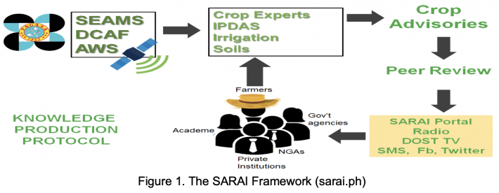
Project SARAI is concentrating on the following 9 priority crops: rice, corn, coconut, sugar cane, banana, coffee, cacao, tomato and soybeans but its system is also applicable to other crops (SARAI, 2018). To realize its goals, the Project SARAI team of scientists, researchers, extension workers, local government personnel and participating private organizations had formulated the SARAI framework (Figure 1). The framework identifies the various components and their interactions to provide farmers with science-based advisories for managing their farms.
SARAI-Phase 2 has 15 project components classified under three subprograms: 1.) Crop characterization, integrated crop management, and model development; 2.) Crop-environment monitoring and forecasting; and 3.) SARAI mainstreaming (Domingo, 2018).
The main components of the SARAI system are the following:
- SARAI-Enhanced Agriculture Monitoring System (SEAMS);
- Water Balance-Assisted Irrigation Decision Support System (WAISS);
- Drought and Crop Assessment and Forecasting (DCAF);
- Smarter Pest Identification Technology (SPId Tech);
- Soil Profiling and Characterization;
- Maize Nutrient Expert;
- SARAI Automatic Soil and Weather Monitoring and Forecasting System;
- SARAI Crop Health Assessment and Monitoring System using Drones;
- SARAI Knowledge Portal, Mobile and Web-based Applications for Agriculture; and
- Capacity and Knowledge Building
These technologies together with science-based methodologies are combined with crop forecasting models to provide information to the farmers such as what to plant, when to plant, how to manage their crops to increase productivity. This information is disseminated to the target farmers using various media such as the Internet, smartphones, short messaging service, radio, television and print media.
Since majority of the target farmers have limited access to online materials, these materials are also disseminated by the partner universities (University of the Philippines and 11 State Colleges and Universities), the Department of Agriculture regional offices, Provincial and Municipal Agricultural Officers (PAO and MAO) and farmer organizations through consultations, meetings and trainings.
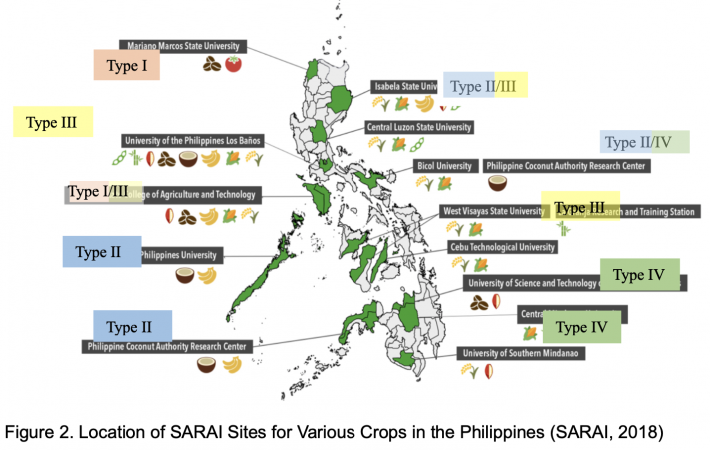
The SARAI technologies and systems are tested in various locations in the Philippines for different recognized climate types based on the distribution of rainfall (PAGASA, 2019). They are described as follows:
Type I. Two pronounced seasons: dry from November to April and wet during the rest of the year;
Type II. No dry season with a pronounced rainfall from November to January;
Type III. Seasons are not very pronounced, relatively dry from November to April, and wet during the rest of the year; and
Type IV. Rainfall is more or less evenly distributed throughout the year.
These locations were chosen such that the results of the field trials of the various technologies in the chosen areas will be applicable to other areas with similar crop and soil conditions and climate types (Figure 2).
THE SARAI TECHNOLOGIES APPLIED IN THE PHILIPPINE AGRICULTURAL SECTOR
The SARAI technologies are the results of the compilation of tested science-based systems, methodologies and proven technologies for the agricultural sector. Some of the technologies were designed primarily for the agricultural sector while others were adapted from other sectors. These systems and technologies are described in this section.
SARAI-Enhanced Agriculture Monitoring System (SEAMS)
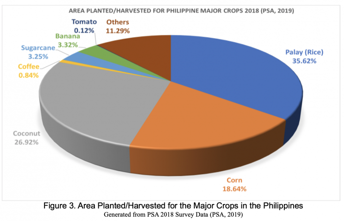
The SARAI-Enhanced Agriculture Monitoring System or SEAMS is a system developed by the engineering team of Project SARAI to monitor agricultural crops in the Philippines. It uses images taken by the Moderate Resolution Imaging Spectroradiometer (MODIS) and Sentinel-1 and Sentinel-2 satellites. From the satellite images, information such as the size of agricultural areas planted to major crops, locations where these crops are planted, growth stage of the crops can be monitored. This satellite-derived information is useful for validating data generated by surveys (Figure 3). Monitoring of crop production areas is also useful in the national, regional, provincial, down to the farmer level. By providing crop-weather information and advisories to stakeholders on the occurrence of extreme weather conditions such as typhoons and droughts, the system can serve as an agricultural early warning system.
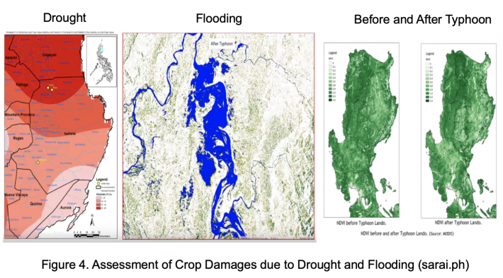
Using Normalized Differential Vegetation Index (NDVI) values from satellite images, the system can also be used to determine size and extent of crop damages due to drought, flooding, typhoons and other weather disturbances (Figure 4).
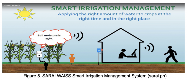
Water Balance-Assisted Irrigation Decision Support System (WAISS)
The SARAI Water Balance-Assisted Irrigation Support System (WAISS) is the technology that uses a model developed for estimating soil moisture deficit in annual crops. The system uses fabricated cost-efficient soil moisture monitoring system to determine the soil moisture and relays this information to a server (Figure 5). The SARAI system, using the information about the soil type, type of crops planted in the area, growth stage of the crops, moisture content in the soil and weather forecasts, provides advice to the farmer if the crops need irrigation or not, thus optimizing the use of water resources. The irrigation system can also be programmed to automatically irrigate the crops instead of just informing the farmer when to irrigate.
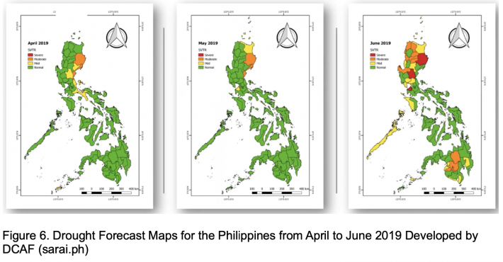
Drought and Crop Assessment and Forecasting (DCAF)
Drought and Crop Assessment and Forecasting (DCAF) component of SARAI is an applied science research combining the fields of Agriculture, Environmental Science, Hydrology, Atmospheric Science, and Remote Sensing with the vision of improving the nation’s capability of predicting drought occurrences, assessing crop yield and mitigating severe effects of drought in the Philippines. Through assessment and forecasting of drought occurrences, this project component provides policy makers, government agencies, farmers and the general public with tools needed to formulate strategies to meet the impacts of upcoming events. These tools are in form of maps that would facilitate evaluation of magnitude and extent of drought risks (Figure 6).
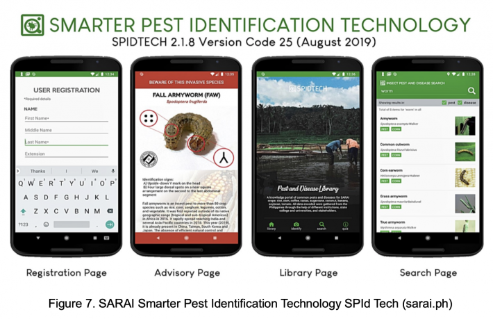
Smarter Pest Identification Technology (SPId Tech)
The Smarter Pest Identification Technology or SPId Tech is an Android application program of the Insect Pest and Disease Advisory System (IPDAS) project component of SARAI which can identify pests through face recognition protocols (Figure 7). The users only need to upload the photos of the pests and wait for the application to identify the pest. The system uses Artificial Intelligence (AI) to identify the pest using rules developed when the system learns the identification process through the aid of pest experts of the National Crop Protection Center at the University of the Philippines Los Baños.
The system not only identifies the pest but also provides management protocols on how to control the pest to prevent crop damage. Using crowd sourcing, pest occurrences in the field can be reported to the system through its reporting mechanism. By analyzing the pest occurrences together with other information such as type of crops in the area, growth stage of the crops, weather conditions, the system can identify hot spots and warn the farmers of a possibility of pest outbreak in the area thereby providing an early warning system.
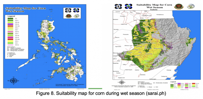
Soil profiling and Characterization
Soil sampling and profiling can be performed on the study sites around the Philippines. The collected soil samples are sent to the laboratory for physical, chemical, and mineralogical analyses. The results obtained from the soil sample analysis before the start of the crop experimental trials can be used as baseline data which the researchers can utilize for their fertilizer application and water and crop management experiments. The same data together with other information such as elevation, slope, climate types, rainfall patterns and temperature can be used to generate suitability maps for different crops (Figure 8). During the growth period of the crop, soil samples will be taken and analyzed as necessary. These data together with other crop data can be used in the analysis of the crop status and characteristics. For soil moisture monitoring at longer periods of time, soil moisture sensors similar to the ones used in the SARAI Soil and Weather Monitoring and Forecasting System and the WAISS set-up can be used. With this set-up, the changes in soils moisture will be continuously monitored.
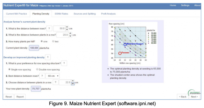
The Maize Nutrient Expert
The Maize Nutrient Expert was developed with the International Plant Nutrition Institute (Pampolino, 2017). Project SARAI enhanced the system by translating it to an online digital platform (Figure 9). The enhanced system can provide a comprehensive farm analysis – from specific NPK applications, to a comparison of the profit of farmers’ practice and the recommended practices.
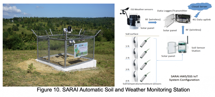
SARAI Automatic Soil and Weather Monitoring and Forecasting System
The SARAI Automatic Soil and Weather Monitoring and Forecasting System uses a network of 20 installed Automatic Weather Stations (AWS) all over the Philippines to provide real-time weather information as well as short term or 10-day local weather forecasts to the farmers (Figure 10). The system uploads real-time weather data (rainfall, humidity, wind speed/direction, barometric pressure, solar and UV radiation, soil temperature and soil moisture to a cloud server every 15 minutes and makes them available to farmers, local government units and academe and other interested parties for crop management decision making.
The gathered data are also used as input to the SARAI Crop and Climate Forecasting System which provide information and advice to farmers about crop weather conditions, what to plant, when to plant, how to manage their farms and when the best time to harvest.
The data gathered from the network of automatic weather stations and the generated weather forecasts are provided in the SARAI Knowledge Portal (Figure 11).

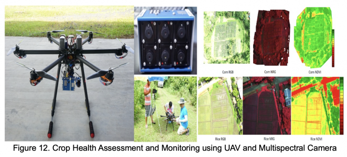
SARAI Crop Health Assessment and Monitoring System using Drones
The SARAI Crop Health Assessment and Monitoring System uses Unmanned Aerial Vehicles (UAV) or drones equipped with RGB and multispectral cameras to determine the different vegetation indices (Normalized Differential Vegetation Index or NDVI, Soil Adjusted Vegetation Index or SAVI, Enhanced Vegetation Index or EVI) of the crops to determine plant health status (Figure 12). Using the various vegetation indices, the system can identify plant stress, nutrient and water imbalance, damages due to pest infestation, diseases and adverse weather conditions. With regular monitoring of crops, specific spectral signatures for various crops can be determined. These spectral crop signatures can be used to identify crops remotely and can be used to validate NDVI images taken by satellites.
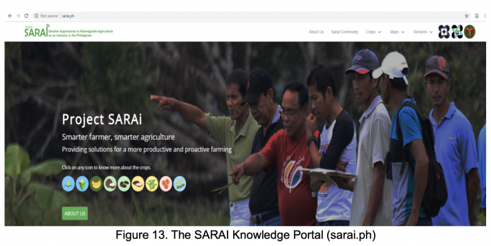
SARAI Knowledge Portal, Mobile and Web-based Applications for Agriculture
The SARAI Knowledge Portal provides the outputs of the various SARAI components in a form that can be directly or indirectly utilized by the farmers (Figure 13). For example, through the portal, real-time weather data, short term weather forecasts and 6 month rainfall outlook are provided as tables and graphs which could be utilized in making informed decisions ahead of time. Other information about crops such as their characteristics, yield potential, suitability, best planting and management practices, risks due to pests and diseases are also made available through the SARAI Knowledge Portal. These information can be used by the Agricultural Extension Officers in formulating advisories which in turn could be relayed to the farmers personally or through other media such as radio, television and short messaging system.
The technologies available online through the SARAI Knowledge Portal are re-engineered to provide accessible mobile applications that can be delivered by province or by municipality to individual users.
This system will enable exchange and transfer of agricultural knowledge generated from research at national, regional and provincial levels. Examples of available information at the SARAI Knowledge Portal are:
- Real-time weather data in the form of tables and graphs;
-
Short-term weather forecasts and long-term rainfall outlook;
-
Normalized Difference Vegetation Index maps of various crops;
-
Multispectral images of experimental sites;
-
Suitability maps for the various crops;
-
Rainfall maps;
-
Vulnerability maps;
-
Agricultural drought maps;
-
Crop planting calendars;
-
Crop calculators;
-
Pest and diseases advisories;
-
Learning modules and video lessons; and
-
Other services
Knowledge and Capacity Building
The Knowledge and Capacity Building component project serves as a holistic enterprise that binds all the projects of the SARAI research program to ensure that their outputs are translated into building abilities, relationships and values that will enable the farming communities to improve their productivity. It is tasked to conduct the Training Needs Assessment (TNA) with SARAI stakeholders to ensure that outputs from the various projects of the proposed program are translated into meaningful information and tools. These tools had been tested to meet the identified learning criteria to ensure that the technical capacities of stakeholders are strengthened. Furthermore, the project sees to it that individuals and institutions are fully equipped to understand, appreciate and apply SARAI-related technologies (SARAI, 2019).
CONCLUSION
Although the Philippines is located in a region where climate hazards are always a threat to both life and property, history had proven that the people of this country had always find ways of adapting and recovering from disasters striking this nation. Every year, the agricultural sector of this country suffers major losses in millions of dollars due to the adverse effect of climate change. With these reasons, Project SARAI was envisioned to make use of various technologies and methodologies to provide the needed advice to farmers in mitigating the effect of climate change to agriculture. The SARAI-Enhanced Agriculture Monitoring System (SEAMS) provides the methods and tools in monitoring crop and environment conditions using satellite, local weather stations and other ground data. The SARAI Water-Balance Irrigation Decision Support System (WAISS) provides the water monitoring system with real-time advisories to optimize irrigation and conserve water. The SARAI Automatic Weather Monitoring System provides real-time weather data and forecasts that the farmers can use in their crop management decision making. Suitability maps, vulnerability maps, agricultural drought forecast maps, vegetation index maps are made available in the SARAI Knowledge Portal free for farmers to use so that they will be more equipped in reducing their risks due to climate related hazards.
The SARAI team of scientists and researchers had tested all these technologies in various parts of the country for different soil and climate types and had shown that they can provide additional advantage to the farmers if adapted properly. Mainstreaming these technologies for wider use is being done through consultative meetings with various stake holders and policy makers, public awareness through presentations, exhibits, trainings, workshops, dissemination of instructional, educational and communication (IEC) materials. All these efforts are gaining ground and the nation is becoming aware that these technologies can help in improving agriculture in the Philippines.
REFERENCES
Basso, B., Cammarano D., Carfagna, E. (2013). Review of Crop Yield Forecasting Methods and Early Warning Systems. GS SAC – Improving methods for crops estimates, FAO Publication, Rome, Italy.
Cabangbang R.P., Espaldon M.V.O, et al. (2019). Paving the Pathway for Climate Smart Agriculture Among Small Scale Farmers in the Philippines. Extension Bulletins. Food and Fertilizer Technology Center for the Asian and Pacific Region. Taipei Taiwan.
Domingo O.F. (2018). Farmers to Benefit from SARAI Phase 2 Program. Department of Science and Technology-Philippine Council for Agriculture, Aquatic and Natural Resources Research and Development. Los Baños, Laguna.
FAO. (2014). Crop Monitoring and Forecasting.
IPNI. (2019). International Plant Nutrition Institute. (http://ipni.net) accessed on 2019/08/29
PAGASA. (2019), Climate Types. Philippine Atmospheric, Geophysical and Astronomical Services Administration, Department of Science and Technology. (http:// http://bagong.pagasa.dost.gov.ph/information/climate-philippines) accessed on 2019/08/29.
Pampolino M., Serrano J.I., Luar L., Perez J., Paduit N. (2017). Nutrient Expert (Philippines) Web App User Manual. International Plant Nutrition Institute, Southeast Asia Program, Los Baños, Philippines.
PSA. (2019). Selected Statistics on Agriculture 2019. Philippine Statistics Authority. Quezon City, Philippines.
SARAI. (2018), Proposal for the Project Smarter Approaches to Reinvigorate Agriculture as an Industry in the Philippines (Project SARAI) Phase I and II, the Department of Science and Technology-Philippine Council for Agriculture, Aquatic and Natural Resources Research and Development and the University of the Philippines Los Baños, Laguna.
SARAI. (2019). Project Smarter Approaches to Reinvigorate Agriculture as an Industry in the Philippines (Project SARAI) Knowledge Portal, the Department of Science and Technology-Philippine Council for Agriculture, Aquatic and Natural Resources Research and Development and the University of the Philippines Los Baños, Laguna. (http://sarai.ph) accessed on 2019/08/29.
|
Date submitted: October 29, 2019
Reviewed, edited and uploaded: December 2, 2019
|

Project Sarai Technologies for Climate-Smart Agricultural in the Philippines
ABSTRACT
The Philippines, being located in the Asian region that is frequently visited by typhoons, is considered to be one of the most vulnerable countries to hazards brought about by bad weather conditions. With an increasing frequency of stronger typhoons coupled with severe flooding during rainy seasons and prolonged drought conditions during dry seasons caused by climate change, the Philippine agricultural sector continue to suffer heavy losses, estimated to be about Php37B or US$728M between 2017-2018 alone (DA 2019). To lessen the adverse effects of changing climate in the agricultural sector, science-based technologies and solutions such as satellite remote sensing, weather monitoring and forecasting, drones, multispectral imaging, integrated crop and pest and disease management, soil and water management, and crop modeling suited to the farms in the local communities are being tested by Project SARAI (Smarter Approaches to Reinvigorate Agriculture as an Industry in the Philippines). This paper describes how these technologies and solutions are being utilized in the Philippines to help local farmers reduce their risks to climate related hazards.
Keywords: Smart agriculture, satellite remote sensing, weather monitoring and forecasting, drone, multispectral imaging, integrated crop and pest management, water and soil management, crop modeling, project SARAI
INTRODUCTION
Agriculture’s vital role in the Philippine economy and food security is constantly being threatened by climate change. The need to develop mechanisms for crop-climate information transfer to enhance farmers’ adaptive capacity regarding crop production continues to be a challenge among research institutions and policy and decision makers.
In 2001, experts invited by the Food and Agriculture Organization of the United Nations (FAO) for the eighteenth session of the Asia and Pacific Commission on Agricultural Statistics stressed the importance of a Crop Forecasting Systems (CFS) in food security programs and as a climate change adaptation tool, however many developing countries have yet to institutionalize it. A CFS will enable farming communities to estimate not only crop yields, but also production losses to aid in reallocation of food supply in case of climatic extremes (FAO, 2014).
Advancement in science and technology have paved the way to address the gaps for further refinement of crop forecasting methodologies to generate more accurate and timely crop estimates. The integrated use of Crop Simulation Model (CSM), Remote Sensing (RS), Geographic Information System (GIS), and Vegetation Indices (VI) in crop forecasting have been increasing, particularly in developing countries (Basso, 2013).
With technology barriers slowly dissipating and data gaps being gradually filled in, the Philippines is now in a position to incorporate these methodologies to provide stakeholders in the agriculture system much needed crop-climate information.
Project SARAI, the University of the Philippines' contribution to the agricultural sector
The University of the Philippines Los Baños (UPLB) together with 11 State Colleges and Universities (SUC) all over the Philippines have implemented a national project funded by the Philippine Council for Agriculture, Aquatic and Natural Resources Research and Development of the Department of Science and Technology (DOST-PCAARRD) in partnership with the Philippine Rice Research Institute (PhilRICE), Philippine Coconut Authority (PCA) and Sugar Regulatory Administration (SRA) of the Department of Agriculture to implement developed methodologies and technologies in various local farms in the country. The partnership targeted its support to the farmers of the various communities, local government units (LGU) and farmer's associations.
The developed science-based methodologies and technologies were packaged into a project called SARAI or Smarter Approaches to Reinvigorate Agriculture as an Industry. The goal of Project SARAI in its second phase of implementation is to develop, implement, and deploy science-based crops and cropping system technologies, protocols, and long-term strategies which are geared towards maximizing yields and minimizing adverse environmental and climate impacts (Domingo, 2018). Project SARAI had established a real-time crop monitoring and forecasting system for rice, corn, banana, coconut, coffee, and cacao. The system uses crop models, ensemble of weather and climate data, real-time weather data, remote sensing, geographic information system (GIS), and field monitoring reports to come up with near real-time crop monitoring information, and seasonal crop forecast (Cabangbang, 2019).
Project SARAI is concentrating on the following 9 priority crops: rice, corn, coconut, sugar cane, banana, coffee, cacao, tomato and soybeans but its system is also applicable to other crops (SARAI, 2018). To realize its goals, the Project SARAI team of scientists, researchers, extension workers, local government personnel and participating private organizations had formulated the SARAI framework (Figure 1). The framework identifies the various components and their interactions to provide farmers with science-based advisories for managing their farms.
SARAI-Phase 2 has 15 project components classified under three subprograms: 1.) Crop characterization, integrated crop management, and model development; 2.) Crop-environment monitoring and forecasting; and 3.) SARAI mainstreaming (Domingo, 2018).
The main components of the SARAI system are the following:
These technologies together with science-based methodologies are combined with crop forecasting models to provide information to the farmers such as what to plant, when to plant, how to manage their crops to increase productivity. This information is disseminated to the target farmers using various media such as the Internet, smartphones, short messaging service, radio, television and print media.
Since majority of the target farmers have limited access to online materials, these materials are also disseminated by the partner universities (University of the Philippines and 11 State Colleges and Universities), the Department of Agriculture regional offices, Provincial and Municipal Agricultural Officers (PAO and MAO) and farmer organizations through consultations, meetings and trainings.
The SARAI technologies and systems are tested in various locations in the Philippines for different recognized climate types based on the distribution of rainfall (PAGASA, 2019). They are described as follows:
Type I. Two pronounced seasons: dry from November to April and wet during the rest of the year;
Type II. No dry season with a pronounced rainfall from November to January;
Type III. Seasons are not very pronounced, relatively dry from November to April, and wet during the rest of the year; and
Type IV. Rainfall is more or less evenly distributed throughout the year.
These locations were chosen such that the results of the field trials of the various technologies in the chosen areas will be applicable to other areas with similar crop and soil conditions and climate types (Figure 2).
THE SARAI TECHNOLOGIES APPLIED IN THE PHILIPPINE AGRICULTURAL SECTOR
The SARAI technologies are the results of the compilation of tested science-based systems, methodologies and proven technologies for the agricultural sector. Some of the technologies were designed primarily for the agricultural sector while others were adapted from other sectors. These systems and technologies are described in this section.
SARAI-Enhanced Agriculture Monitoring System (SEAMS)
The SARAI-Enhanced Agriculture Monitoring System or SEAMS is a system developed by the engineering team of Project SARAI to monitor agricultural crops in the Philippines. It uses images taken by the Moderate Resolution Imaging Spectroradiometer (MODIS) and Sentinel-1 and Sentinel-2 satellites. From the satellite images, information such as the size of agricultural areas planted to major crops, locations where these crops are planted, growth stage of the crops can be monitored. This satellite-derived information is useful for validating data generated by surveys (Figure 3). Monitoring of crop production areas is also useful in the national, regional, provincial, down to the farmer level. By providing crop-weather information and advisories to stakeholders on the occurrence of extreme weather conditions such as typhoons and droughts, the system can serve as an agricultural early warning system.
Using Normalized Differential Vegetation Index (NDVI) values from satellite images, the system can also be used to determine size and extent of crop damages due to drought, flooding, typhoons and other weather disturbances (Figure 4).
Water Balance-Assisted Irrigation Decision Support System (WAISS)
The SARAI Water Balance-Assisted Irrigation Support System (WAISS) is the technology that uses a model developed for estimating soil moisture deficit in annual crops. The system uses fabricated cost-efficient soil moisture monitoring system to determine the soil moisture and relays this information to a server (Figure 5). The SARAI system, using the information about the soil type, type of crops planted in the area, growth stage of the crops, moisture content in the soil and weather forecasts, provides advice to the farmer if the crops need irrigation or not, thus optimizing the use of water resources. The irrigation system can also be programmed to automatically irrigate the crops instead of just informing the farmer when to irrigate.
Drought and Crop Assessment and Forecasting (DCAF)
Drought and Crop Assessment and Forecasting (DCAF) component of SARAI is an applied science research combining the fields of Agriculture, Environmental Science, Hydrology, Atmospheric Science, and Remote Sensing with the vision of improving the nation’s capability of predicting drought occurrences, assessing crop yield and mitigating severe effects of drought in the Philippines. Through assessment and forecasting of drought occurrences, this project component provides policy makers, government agencies, farmers and the general public with tools needed to formulate strategies to meet the impacts of upcoming events. These tools are in form of maps that would facilitate evaluation of magnitude and extent of drought risks (Figure 6).
Smarter Pest Identification Technology (SPId Tech)
The Smarter Pest Identification Technology or SPId Tech is an Android application program of the Insect Pest and Disease Advisory System (IPDAS) project component of SARAI which can identify pests through face recognition protocols (Figure 7). The users only need to upload the photos of the pests and wait for the application to identify the pest. The system uses Artificial Intelligence (AI) to identify the pest using rules developed when the system learns the identification process through the aid of pest experts of the National Crop Protection Center at the University of the Philippines Los Baños.
The system not only identifies the pest but also provides management protocols on how to control the pest to prevent crop damage. Using crowd sourcing, pest occurrences in the field can be reported to the system through its reporting mechanism. By analyzing the pest occurrences together with other information such as type of crops in the area, growth stage of the crops, weather conditions, the system can identify hot spots and warn the farmers of a possibility of pest outbreak in the area thereby providing an early warning system.
Soil profiling and Characterization
Soil sampling and profiling can be performed on the study sites around the Philippines. The collected soil samples are sent to the laboratory for physical, chemical, and mineralogical analyses. The results obtained from the soil sample analysis before the start of the crop experimental trials can be used as baseline data which the researchers can utilize for their fertilizer application and water and crop management experiments. The same data together with other information such as elevation, slope, climate types, rainfall patterns and temperature can be used to generate suitability maps for different crops (Figure 8). During the growth period of the crop, soil samples will be taken and analyzed as necessary. These data together with other crop data can be used in the analysis of the crop status and characteristics. For soil moisture monitoring at longer periods of time, soil moisture sensors similar to the ones used in the SARAI Soil and Weather Monitoring and Forecasting System and the WAISS set-up can be used. With this set-up, the changes in soils moisture will be continuously monitored.
The Maize Nutrient Expert
The Maize Nutrient Expert was developed with the International Plant Nutrition Institute (Pampolino, 2017). Project SARAI enhanced the system by translating it to an online digital platform (Figure 9). The enhanced system can provide a comprehensive farm analysis – from specific NPK applications, to a comparison of the profit of farmers’ practice and the recommended practices.
SARAI Automatic Soil and Weather Monitoring and Forecasting System
The SARAI Automatic Soil and Weather Monitoring and Forecasting System uses a network of 20 installed Automatic Weather Stations (AWS) all over the Philippines to provide real-time weather information as well as short term or 10-day local weather forecasts to the farmers (Figure 10). The system uploads real-time weather data (rainfall, humidity, wind speed/direction, barometric pressure, solar and UV radiation, soil temperature and soil moisture to a cloud server every 15 minutes and makes them available to farmers, local government units and academe and other interested parties for crop management decision making.
The gathered data are also used as input to the SARAI Crop and Climate Forecasting System which provide information and advice to farmers about crop weather conditions, what to plant, when to plant, how to manage their farms and when the best time to harvest.
The data gathered from the network of automatic weather stations and the generated weather forecasts are provided in the SARAI Knowledge Portal (Figure 11).
SARAI Crop Health Assessment and Monitoring System using Drones
The SARAI Crop Health Assessment and Monitoring System uses Unmanned Aerial Vehicles (UAV) or drones equipped with RGB and multispectral cameras to determine the different vegetation indices (Normalized Differential Vegetation Index or NDVI, Soil Adjusted Vegetation Index or SAVI, Enhanced Vegetation Index or EVI) of the crops to determine plant health status (Figure 12). Using the various vegetation indices, the system can identify plant stress, nutrient and water imbalance, damages due to pest infestation, diseases and adverse weather conditions. With regular monitoring of crops, specific spectral signatures for various crops can be determined. These spectral crop signatures can be used to identify crops remotely and can be used to validate NDVI images taken by satellites.
SARAI Knowledge Portal, Mobile and Web-based Applications for Agriculture
The SARAI Knowledge Portal provides the outputs of the various SARAI components in a form that can be directly or indirectly utilized by the farmers (Figure 13). For example, through the portal, real-time weather data, short term weather forecasts and 6 month rainfall outlook are provided as tables and graphs which could be utilized in making informed decisions ahead of time. Other information about crops such as their characteristics, yield potential, suitability, best planting and management practices, risks due to pests and diseases are also made available through the SARAI Knowledge Portal. These information can be used by the Agricultural Extension Officers in formulating advisories which in turn could be relayed to the farmers personally or through other media such as radio, television and short messaging system.
The technologies available online through the SARAI Knowledge Portal are re-engineered to provide accessible mobile applications that can be delivered by province or by municipality to individual users.
This system will enable exchange and transfer of agricultural knowledge generated from research at national, regional and provincial levels. Examples of available information at the SARAI Knowledge Portal are:
Short-term weather forecasts and long-term rainfall outlook;
Normalized Difference Vegetation Index maps of various crops;
Multispectral images of experimental sites;
Suitability maps for the various crops;
Rainfall maps;
Vulnerability maps;
Agricultural drought maps;
Crop planting calendars;
Crop calculators;
Pest and diseases advisories;
Learning modules and video lessons; and
Other services
Knowledge and Capacity Building
The Knowledge and Capacity Building component project serves as a holistic enterprise that binds all the projects of the SARAI research program to ensure that their outputs are translated into building abilities, relationships and values that will enable the farming communities to improve their productivity. It is tasked to conduct the Training Needs Assessment (TNA) with SARAI stakeholders to ensure that outputs from the various projects of the proposed program are translated into meaningful information and tools. These tools had been tested to meet the identified learning criteria to ensure that the technical capacities of stakeholders are strengthened. Furthermore, the project sees to it that individuals and institutions are fully equipped to understand, appreciate and apply SARAI-related technologies (SARAI, 2019).
CONCLUSION
Although the Philippines is located in a region where climate hazards are always a threat to both life and property, history had proven that the people of this country had always find ways of adapting and recovering from disasters striking this nation. Every year, the agricultural sector of this country suffers major losses in millions of dollars due to the adverse effect of climate change. With these reasons, Project SARAI was envisioned to make use of various technologies and methodologies to provide the needed advice to farmers in mitigating the effect of climate change to agriculture. The SARAI-Enhanced Agriculture Monitoring System (SEAMS) provides the methods and tools in monitoring crop and environment conditions using satellite, local weather stations and other ground data. The SARAI Water-Balance Irrigation Decision Support System (WAISS) provides the water monitoring system with real-time advisories to optimize irrigation and conserve water. The SARAI Automatic Weather Monitoring System provides real-time weather data and forecasts that the farmers can use in their crop management decision making. Suitability maps, vulnerability maps, agricultural drought forecast maps, vegetation index maps are made available in the SARAI Knowledge Portal free for farmers to use so that they will be more equipped in reducing their risks due to climate related hazards.
The SARAI team of scientists and researchers had tested all these technologies in various parts of the country for different soil and climate types and had shown that they can provide additional advantage to the farmers if adapted properly. Mainstreaming these technologies for wider use is being done through consultative meetings with various stake holders and policy makers, public awareness through presentations, exhibits, trainings, workshops, dissemination of instructional, educational and communication (IEC) materials. All these efforts are gaining ground and the nation is becoming aware that these technologies can help in improving agriculture in the Philippines.
REFERENCES
Basso, B., Cammarano D., Carfagna, E. (2013). Review of Crop Yield Forecasting Methods and Early Warning Systems. GS SAC – Improving methods for crops estimates, FAO Publication, Rome, Italy.
Cabangbang R.P., Espaldon M.V.O, et al. (2019). Paving the Pathway for Climate Smart Agriculture Among Small Scale Farmers in the Philippines. Extension Bulletins. Food and Fertilizer Technology Center for the Asian and Pacific Region. Taipei Taiwan.
Domingo O.F. (2018). Farmers to Benefit from SARAI Phase 2 Program. Department of Science and Technology-Philippine Council for Agriculture, Aquatic and Natural Resources Research and Development. Los Baños, Laguna.
FAO. (2014). Crop Monitoring and Forecasting.
IPNI. (2019). International Plant Nutrition Institute. (http://ipni.net) accessed on 2019/08/29
PAGASA. (2019), Climate Types. Philippine Atmospheric, Geophysical and Astronomical Services Administration, Department of Science and Technology. (http:// http://bagong.pagasa.dost.gov.ph/information/climate-philippines) accessed on 2019/08/29.
Pampolino M., Serrano J.I., Luar L., Perez J., Paduit N. (2017). Nutrient Expert (Philippines) Web App User Manual. International Plant Nutrition Institute, Southeast Asia Program, Los Baños, Philippines.
PSA. (2019). Selected Statistics on Agriculture 2019. Philippine Statistics Authority. Quezon City, Philippines.
SARAI. (2018), Proposal for the Project Smarter Approaches to Reinvigorate Agriculture as an Industry in the Philippines (Project SARAI) Phase I and II, the Department of Science and Technology-Philippine Council for Agriculture, Aquatic and Natural Resources Research and Development and the University of the Philippines Los Baños, Laguna.
SARAI. (2019). Project Smarter Approaches to Reinvigorate Agriculture as an Industry in the Philippines (Project SARAI) Knowledge Portal, the Department of Science and Technology-Philippine Council for Agriculture, Aquatic and Natural Resources Research and Development and the University of the Philippines Los Baños, Laguna. (http://sarai.ph) accessed on 2019/08/29.
Date submitted: October 29, 2019
Reviewed, edited and uploaded: December 2, 2019