INTRODUCTION
History of Irrigation Sector and Its Development
The importance of providing adequate water for agricultural production has been fully recognized by the former kings of Myanmar. They gave special attention to the establishment of irrigation networks for paddy cultivation. In the year 379 in Myanmar calendar, (which was a thousand years ago), the diversion systems in Myanmar were improved and established with better irrigation technologies and have remained successful to date. Tank and canal irrigation systems were also constructed in the same year. Subsequent to the entry of the British into Myanmar and attendant colonial period, a Public Works Department was established in the year 1861, for maintenance of buildings and constructions of new irrigation facilities. The activities relating to irrigation were solely handled by the Public Works Department.
After the independence, various irrigation projects have been implemented. Canals, tanks, wells, and pumps are some of the different types of irrigation in Myanmar. Among them, canals and pump irrigation supply water for more than 50% of the total irrigated area. The most substantial increase in irrigated area was in pump irrigation followed by canal-type irrigation system.
The trend of improvement in irrigated areas by type of irrigation facilities from year 2000 to 2008 is shown in Table 1 and Figure 1. For canal irrigation, the area increased from 573,000 ha in year 2000 to 640,000 ha in 2008. However, there was no improvement or even a slightly decreasing trend in area for pump irrigation with 840,000 ha and 839,000 ha in year 2000 and 2008, respectively. Moreover, the irrigated area in pump irrigation declined in 2004 and 2005, with 764,000 ha and 664,000 ha, respectively. This was 922,000 ha in 2003. Pump irrigation facilities are operated using diesel and electricity. The reason for the decline in irrigated area for this type of irrigation was because of the fuel price increase in those years. This affected the total irrigated area. The total irrigated area was around 80% of the targeted irrigated area. The average growth rate of the irrigated areas from the year 2000 to 2008 was 1.27% for dam/canal irrigation and -1.24% for pump irrigation. This trend could be due to inadequate water availability for pump irrigated areas. Since farmers in pump irrigated areas are not assured of adequate water for their crops, their areas of cultivation had gone down.
Table 1. Irrigated area ( ’000 ha) by type of irrigation facilities, Myanmar, 2000-2008.
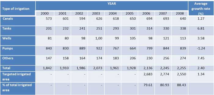
Source: Irrigation Department (2009)
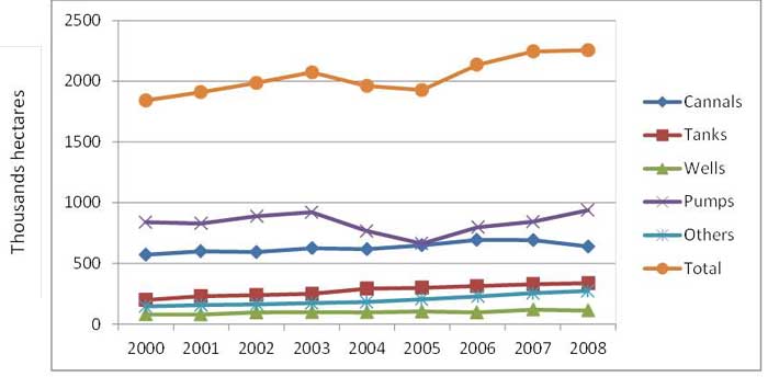
Fig. 1. Irrigated area by type of irrigation facilities, Myanmar, 2000-2008
The agricultural policy has stressed self-sufficiency of rice in each administrative region, including rice deficit areas, which conflicts against the cultivation according to the principle of comparative advantage (Fujita and Okamoto 2006: 10). Farmers were thus forced to cultivate rice in designated areas, especially those with irrigation, as a condition of access to the land and inputs. Prevailing policy has been to impose the cultivation of rice as at least one of the crops in all irrigated areas. Thus, a lot of the areas has been reserved to grow rice only, regardless of the conditions and the traditional crops grown by the farmers.
Summer rice programme was introduced in 1992 along with the use of short-lived high yielding varieties together with providing irrigation water. As the yield of summer rice is more than monsoon rice, sown area of summer rice has been increased significantly. Therefore, the total rice sown area has reached 8,090 thousand ha in 2008-09 from 6,138 ha in 1995-06. The area, yield and production of paddy from 1995-96 to 2008-09 are shown in Table 2. Paddy output shows an increasing trend with 18,580 thousand metric tons in 1995-96 and 32,575 metric tons in 2008-09 with average growth rate 10.55% in the same period.
Table 2. Rice area, yield and production in Myanmar, 1995-96 - 2008-09.
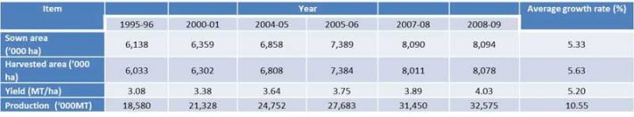
Source: Myanmar Agriculture at a Glance, 2009
This improvement in production of the rice sector was not possible without the development of irrigation facilities. Table 3 shows the number of dams, state/division wise, in Myanmar from 1990 to 2010. In 2010, there were 233 dams in Myanmar with the largest number coming from Mandalay, followed by Bago and Magway Division with 55, 48 and 47 dams, respectively.
Table 3. Number of irrigation dams, Myanmar, 1990-2010.
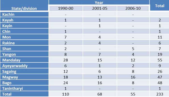
Source: Irrigation Department (2010)
In addition to the construction of dams/canals, 322 river pump stations, 7,932 tube wells, and 8,490 underground water irrigations were established for rural water supply and agricultural use. The number of completed irrigation works (dams, river pumping stations) and underground water irrigation projects with the benefited area by state and division after 1988 are shown in Table 4.
Table 4. Completed irrigation works and benefited area after 1988 by state and division, Myanmar.
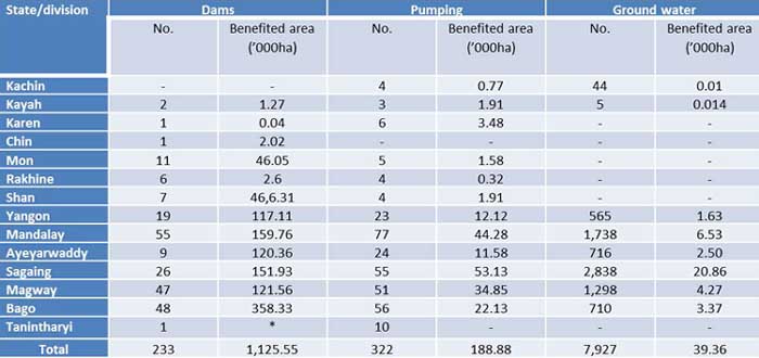
* For household water supply
Source: Irrigation Department, 2010
Irrigation works are concentrated in the central dry zone area with the largest benefited area (597,156.95 ha), which is around 50 % of the total benefited area of the three irrigation systems in the whole country. The number of pump irrigation stations in that area is more than 50 % of total number in the whole country. The need for water is highest in the central dry zone area which is water shortage prone due to low and erratic annual rainfall. Unlike in other parts of the country, monsoon usually comes very late. It starts in mid-July and ends in October. The highest temperature recorded is about 45oC and is even rising nowadays. Average rainfall in this region is 650 mm per year. The area is characterised by clay and sandy soil which are high risk to water and wind erosion leading to land degradation and declining agricultural production. Due to low water holding capacity of soil characteristics, the area is unable to get sufficient water from the stream even during the rainy season. However, most of the cropping occurs in this area. For this reason, the government has given more favor for constructing irrigation facilities in this area to assure water for cultivation thus providing opportunity for an equal socioeconomic status for the people across the country.
As the number of irrigation facilities increased, the irrigated areas have increased to 2.28 million ha which is 17 % of the total net sown area (Table 5). Net sown area increased with average growth rate of 4.03%, similar to that for irrigated areas. This means that the net sown areas increased due to the development of irrigation facilities.
Table 5. Irrigated area, Myanmar, 1996-07 - 2008-09.
Source: Irrigation Department
The development in irrigation facilities has not only led to expansion of areas under cultivation but also increased cropping intensity. This is due to availability of irrigation water making it possible to cultivate twice or three times in the same area per year (Table 6). The average growth rate of net sown area from 1996-07 to 2008-09 was 4.03% and that of cropping intensity was 2.73 % for the same years. The increase in area under cultivation and cropping intensity can improve farmers’ income, thereby improving their socio-economic status.
Table 6. Cropping intensity, Myanmar, 1996-97 - 2008-09.
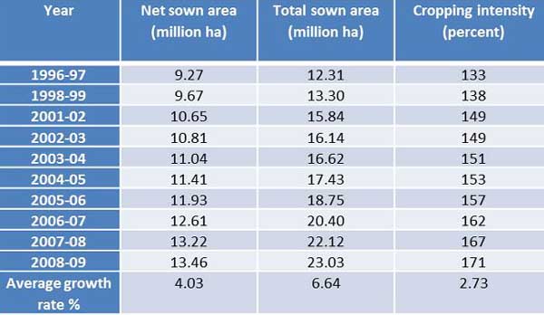
Source: Irrigation department (2010)
Water tax and embankment tax
Beginning from the reign of King Anawrahta and successive monarchs, farmers engaged in cultivation in the command area and were required to give two baskets of paddy per unit of 1.75 acres as land revenue, and were subjected to a fine of K. 1,000 for damages to canals and 1,000 Kyats[1] for damages to paddy land.
The Pyithu Hluttaw session of 1982 under law 1 enacted the water tax and embankment tax law as follows:
(a) Water tax at the rate of ten Kyats per acre for localities enjoying irrigable water from government diversions and reservoirs
(b) Embankment tax at the rate of five Kyats per acre for localities under the protection of government embankment and drainage canals, and
(c) Charges of ten Kyats per acre for localities enjoying both irrigation as well as flood protection facilities.
Starting from the 2007-2008 financial year, the government of the Union of Myanmar enacted the water tax and embankment tax law. The legible rates according to the enactment are as follows:
(A) For the beneficiary areas of irrigation system constructed and maintained by the State, water tax is as follows.
(1) If fully irrigated from land preparation to heading stage at the paddy cultivation areas, the water tax is 1950 Kyats1 per acre.
(2) For any other crops except paddy, the water tax for use of irrigation water for crop cultivation is 900 Kyats per acre.
(3) At the paddy cultivation areas, if irrigated only for land preparation (or) transplanting (or) seedling (or) reproduction (or) heading (or) partial irrigation, the water tax is same as the other crops at the rate of 900 Kyats per acre.
(B) For the beneficiary areas protected from flood with the embankments and drainages constructed and maintained by the State, the water tax is 5 Kyats per acre.
(C) If any cultivated land is inclusive both for items (A) and (B), the water tax is the same rate as in item (A).
The annual budget for the maintenance and repair of the facilities is mostly paid by the government.
However, the water tax in the river pumping system of the WRUD is higher than that of the dam projects which is 9,000 Kyats per acre for rice crop and 6,000 Kyats per acre for other crops.
Evolution of Myanmar water policy and institutional framework for water resource management in agriculture
According to the existing legislation, the ownership of water resource is vested in the Union of Myanmar. The first act was the Burma Canal Act enacted in 1905 which regulated irrigation, navigation and drainage in Myanmar. This act permitted water in all rivers and streams flowing in natural channels as well as lakes and other national still water bodies to be used and controlled for public purposes.
The water law or other provisions thereof are contained in the following laws and their amendments:
(a) The Rangoon Water Works Act, 1885
(b) The Burma Municipal Act, 1898
(c) The Burma Canal Act, 1905 as amended by the Burma Act, 1914, 1924, 1928 and 1934
(d) The Burma Embankment Act, 1905 as amended by the Burma Act, 1923, and 1931
(e) The City of Rangoon Municipal Act 1922
At present, a separate and relevant national water policy on water allocation does not exist in Myanmar. The main objective of water resource allocation is to make efficient use of available resources for the well-being of the people. Water use in Myanmar, in decreasing order of priority, includes the domestic, irrigation, hydropower, industry, fisheries and aquaculture sectors. Generally, there is no standing order or Act or Rules prohibiting the exploitation of either surface or subsurface water. Some of the existing Acts or Rules are almost two-thirds century old and are no longer applicable or suitable to the present situation.
Myanmar water vision was formulated in 2003 in cooperation with UNSCAP, FAO and Irrigation Department (ID) with the participation of all the stakeholders. It states that “By the year 2030, the country will have an attainment of sustainability of water resources to ensure sufficient water quality of acceptable quality to meet the needs of people of country in terms of health, food security, economy and environment”. The Myanmar Water Resource Committee (MWRC) was established in 2005. In order to implement the Myanmar water vision, Myanmar has planned to set up the Myanmar Water Commission (MWC) by including two main categories, i.e., consumptive users ministries and non-consumptive users ministries under the exiting national apex body. Moreover, other coordination and relevant ministries together with private sector and NGOs will also be included. The organizational charts for existing net work and planned MWC are shown in Figures 2 and 3, respectively.
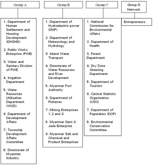
Fig. 2. Organizational chart of existing network
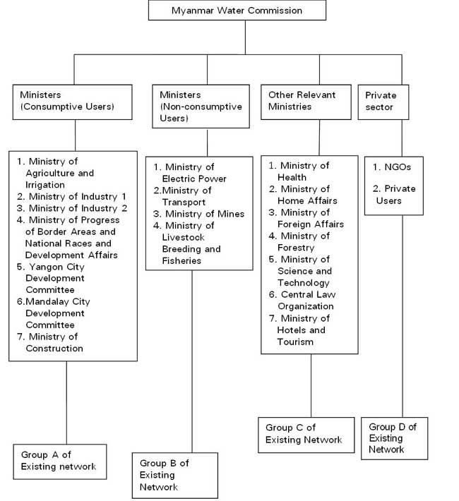
Fig. 3. Organizational chart of Planned Myanmar Water Commission
For water use in agriculture sector, the principal government institutions are the Irrigation Department (ID) and the Water Resource Utilization Department (WRUD), both under the Ministry of Agriculture and Irrigation (MOAI). WRUD is responsible for river and groundwater pumping irrigation and rural water supply in locations where pumping is the only option for the best use of the prevailing water sources. It has been implementing the pump irrigation water supply programme using high discharge capacity pumps since 1995. ID, on the other hand, is responsible for the construction of new dams and irrigation schemes.
The farmers have the role to maintain and operate the terminal units such as field ditches and watercourses. In some irrigated areas, there are already existing Water User Groups (WUGs). Each WUG has an elected leader whose main role is to oversee works related to the operation and maintenance (O&M) of the field ditches and tertiary canals. The main task of WUG is to distribute water fairly among the members and its main responsibilities are to resolve the conflicts, share the irrigation water equitably, and expedite the timely payment for water charges.
The WUGs are under the control of the township agriculture supervision committee. This committee is chaired by the Chairman of the Township Peace and Development Council and the committee members include officers of relevant departments such as ID, Myanmar Agriculture Service (MAS), Settlement and Land Record Department (SLRD), and others. The formation of WUGs was accelerated in 2010 and altogether 166 groups have been established throughout the country covering about 40 % of total irrigation network system. But there is little coordination among WUGs members. There should be strong coordination and cooperation between the members in determining whether they are getting sufficient water or not by checking the distribution of water along the system. Meetings should be conducted at least monthly for those committees in order to get accurate and direct information from the farm level regarding the distribution of water in the system.
Parallel to the formation of WUGs, another type of farmers’ group called "Ten Farmers Group” (TFG) was established at the village level under the organization of the MAS. TFG is the smallest unit of farmers' organization which is also contributing towards increased awareness on water management. The main difference is that WUGs were established based on irrigation network system and TFGs were based on number of farmers. TFGs were established in 13,077 village tracts throughout the country as of the end of November 2010. The formation of TFGs is also a platform to raise the voices of the farmers through their leaders in all aspects of agriculture including irrigation. As per interview with farmers in the study area, there are two leaders in each TFG, one is head end user and the other is tail end user of the same water distribution system.
Conclusion
Since there is no single umbrella law that would cover all aspects of water resource and given the number of government water supply agencies implementing varying water pricing policies, there is little coordination for the purpose of supply and management of water for agriculture, industrial, domestic and sanitation use. In order to overcome problems caused by the lack of regulations on water and water resource management and utilization, the development of water policy is an urgent need, and cooperation and coordination among responsible agencies should be strengthened.
References
Fujita K. and O. Ikuko. 2006. Agricultural policies and development of Myanmar’s agricultural sector: An overview. Discussion paper No. 63. Institute of Developing Economics.
Myanmar agricultural sector review investment strategy: Analysis and Investment Strategy Formulation, Volume 1 (2002), Government of Myanmar and Uniterd Nation Development Program and Food and Agriculture Organization
Naing M. M. 2005. Paddy field irrigation systems in Myanmar. Irrigation Department, Ministry of Agriculture and Irrigation, Myanmar.
Water Policy, Myanmar. 2011. Background paper for development policy options, Myanmar.
[1] / One US Dollar = 825 Kyats
|
Date submitted: March 1, 2016
Reviewed, edited and uploaded: March 3, 2016
|

Overview of Irrigation Development and Government Policy in Myanmar
INTRODUCTION
History of Irrigation Sector and Its Development
The importance of providing adequate water for agricultural production has been fully recognized by the former kings of Myanmar. They gave special attention to the establishment of irrigation networks for paddy cultivation. In the year 379 in Myanmar calendar, (which was a thousand years ago), the diversion systems in Myanmar were improved and established with better irrigation technologies and have remained successful to date. Tank and canal irrigation systems were also constructed in the same year. Subsequent to the entry of the British into Myanmar and attendant colonial period, a Public Works Department was established in the year 1861, for maintenance of buildings and constructions of new irrigation facilities. The activities relating to irrigation were solely handled by the Public Works Department.
After the independence, various irrigation projects have been implemented. Canals, tanks, wells, and pumps are some of the different types of irrigation in Myanmar. Among them, canals and pump irrigation supply water for more than 50% of the total irrigated area. The most substantial increase in irrigated area was in pump irrigation followed by canal-type irrigation system.
The trend of improvement in irrigated areas by type of irrigation facilities from year 2000 to 2008 is shown in Table 1 and Figure 1. For canal irrigation, the area increased from 573,000 ha in year 2000 to 640,000 ha in 2008. However, there was no improvement or even a slightly decreasing trend in area for pump irrigation with 840,000 ha and 839,000 ha in year 2000 and 2008, respectively. Moreover, the irrigated area in pump irrigation declined in 2004 and 2005, with 764,000 ha and 664,000 ha, respectively. This was 922,000 ha in 2003. Pump irrigation facilities are operated using diesel and electricity. The reason for the decline in irrigated area for this type of irrigation was because of the fuel price increase in those years. This affected the total irrigated area. The total irrigated area was around 80% of the targeted irrigated area. The average growth rate of the irrigated areas from the year 2000 to 2008 was 1.27% for dam/canal irrigation and -1.24% for pump irrigation. This trend could be due to inadequate water availability for pump irrigated areas. Since farmers in pump irrigated areas are not assured of adequate water for their crops, their areas of cultivation had gone down.
Table 1. Irrigated area ( ’000 ha) by type of irrigation facilities, Myanmar, 2000-2008.
Source: Irrigation Department (2009)
Fig. 1. Irrigated area by type of irrigation facilities, Myanmar, 2000-2008
The agricultural policy has stressed self-sufficiency of rice in each administrative region, including rice deficit areas, which conflicts against the cultivation according to the principle of comparative advantage (Fujita and Okamoto 2006: 10). Farmers were thus forced to cultivate rice in designated areas, especially those with irrigation, as a condition of access to the land and inputs. Prevailing policy has been to impose the cultivation of rice as at least one of the crops in all irrigated areas. Thus, a lot of the areas has been reserved to grow rice only, regardless of the conditions and the traditional crops grown by the farmers.
Summer rice programme was introduced in 1992 along with the use of short-lived high yielding varieties together with providing irrigation water. As the yield of summer rice is more than monsoon rice, sown area of summer rice has been increased significantly. Therefore, the total rice sown area has reached 8,090 thousand ha in 2008-09 from 6,138 ha in 1995-06. The area, yield and production of paddy from 1995-96 to 2008-09 are shown in Table 2. Paddy output shows an increasing trend with 18,580 thousand metric tons in 1995-96 and 32,575 metric tons in 2008-09 with average growth rate 10.55% in the same period.
Table 2. Rice area, yield and production in Myanmar, 1995-96 - 2008-09.
Source: Myanmar Agriculture at a Glance, 2009
This improvement in production of the rice sector was not possible without the development of irrigation facilities. Table 3 shows the number of dams, state/division wise, in Myanmar from 1990 to 2010. In 2010, there were 233 dams in Myanmar with the largest number coming from Mandalay, followed by Bago and Magway Division with 55, 48 and 47 dams, respectively.
Table 3. Number of irrigation dams, Myanmar, 1990-2010.
Source: Irrigation Department (2010)
In addition to the construction of dams/canals, 322 river pump stations, 7,932 tube wells, and 8,490 underground water irrigations were established for rural water supply and agricultural use. The number of completed irrigation works (dams, river pumping stations) and underground water irrigation projects with the benefited area by state and division after 1988 are shown in Table 4.
Table 4. Completed irrigation works and benefited area after 1988 by state and division, Myanmar.
* For household water supply
Source: Irrigation Department, 2010
Irrigation works are concentrated in the central dry zone area with the largest benefited area (597,156.95 ha), which is around 50 % of the total benefited area of the three irrigation systems in the whole country. The number of pump irrigation stations in that area is more than 50 % of total number in the whole country. The need for water is highest in the central dry zone area which is water shortage prone due to low and erratic annual rainfall. Unlike in other parts of the country, monsoon usually comes very late. It starts in mid-July and ends in October. The highest temperature recorded is about 45oC and is even rising nowadays. Average rainfall in this region is 650 mm per year. The area is characterised by clay and sandy soil which are high risk to water and wind erosion leading to land degradation and declining agricultural production. Due to low water holding capacity of soil characteristics, the area is unable to get sufficient water from the stream even during the rainy season. However, most of the cropping occurs in this area. For this reason, the government has given more favor for constructing irrigation facilities in this area to assure water for cultivation thus providing opportunity for an equal socioeconomic status for the people across the country.
As the number of irrigation facilities increased, the irrigated areas have increased to 2.28 million ha which is 17 % of the total net sown area (Table 5). Net sown area increased with average growth rate of 4.03%, similar to that for irrigated areas. This means that the net sown areas increased due to the development of irrigation facilities.
Table 5. Irrigated area, Myanmar, 1996-07 - 2008-09.
Source: Irrigation Department
The development in irrigation facilities has not only led to expansion of areas under cultivation but also increased cropping intensity. This is due to availability of irrigation water making it possible to cultivate twice or three times in the same area per year (Table 6). The average growth rate of net sown area from 1996-07 to 2008-09 was 4.03% and that of cropping intensity was 2.73 % for the same years. The increase in area under cultivation and cropping intensity can improve farmers’ income, thereby improving their socio-economic status.
Table 6. Cropping intensity, Myanmar, 1996-97 - 2008-09.
Source: Irrigation department (2010)
Water tax and embankment tax
Beginning from the reign of King Anawrahta and successive monarchs, farmers engaged in cultivation in the command area and were required to give two baskets of paddy per unit of 1.75 acres as land revenue, and were subjected to a fine of K. 1,000 for damages to canals and 1,000 Kyats[1] for damages to paddy land.
The Pyithu Hluttaw session of 1982 under law 1 enacted the water tax and embankment tax law as follows:
(a) Water tax at the rate of ten Kyats per acre for localities enjoying irrigable water from government diversions and reservoirs
(b) Embankment tax at the rate of five Kyats per acre for localities under the protection of government embankment and drainage canals, and
(c) Charges of ten Kyats per acre for localities enjoying both irrigation as well as flood protection facilities.
Starting from the 2007-2008 financial year, the government of the Union of Myanmar enacted the water tax and embankment tax law. The legible rates according to the enactment are as follows:
(A) For the beneficiary areas of irrigation system constructed and maintained by the State, water tax is as follows.
(1) If fully irrigated from land preparation to heading stage at the paddy cultivation areas, the water tax is 1950 Kyats1 per acre.
(2) For any other crops except paddy, the water tax for use of irrigation water for crop cultivation is 900 Kyats per acre.
(3) At the paddy cultivation areas, if irrigated only for land preparation (or) transplanting (or) seedling (or) reproduction (or) heading (or) partial irrigation, the water tax is same as the other crops at the rate of 900 Kyats per acre.
(B) For the beneficiary areas protected from flood with the embankments and drainages constructed and maintained by the State, the water tax is 5 Kyats per acre.
(C) If any cultivated land is inclusive both for items (A) and (B), the water tax is the same rate as in item (A).
The annual budget for the maintenance and repair of the facilities is mostly paid by the government.
However, the water tax in the river pumping system of the WRUD is higher than that of the dam projects which is 9,000 Kyats per acre for rice crop and 6,000 Kyats per acre for other crops.
Evolution of Myanmar water policy and institutional framework for water resource management in agriculture
According to the existing legislation, the ownership of water resource is vested in the Union of Myanmar. The first act was the Burma Canal Act enacted in 1905 which regulated irrigation, navigation and drainage in Myanmar. This act permitted water in all rivers and streams flowing in natural channels as well as lakes and other national still water bodies to be used and controlled for public purposes.
The water law or other provisions thereof are contained in the following laws and their amendments:
(a) The Rangoon Water Works Act, 1885
(b) The Burma Municipal Act, 1898
(c) The Burma Canal Act, 1905 as amended by the Burma Act, 1914, 1924, 1928 and 1934
(d) The Burma Embankment Act, 1905 as amended by the Burma Act, 1923, and 1931
(e) The City of Rangoon Municipal Act 1922
At present, a separate and relevant national water policy on water allocation does not exist in Myanmar. The main objective of water resource allocation is to make efficient use of available resources for the well-being of the people. Water use in Myanmar, in decreasing order of priority, includes the domestic, irrigation, hydropower, industry, fisheries and aquaculture sectors. Generally, there is no standing order or Act or Rules prohibiting the exploitation of either surface or subsurface water. Some of the existing Acts or Rules are almost two-thirds century old and are no longer applicable or suitable to the present situation.
Myanmar water vision was formulated in 2003 in cooperation with UNSCAP, FAO and Irrigation Department (ID) with the participation of all the stakeholders. It states that “By the year 2030, the country will have an attainment of sustainability of water resources to ensure sufficient water quality of acceptable quality to meet the needs of people of country in terms of health, food security, economy and environment”. The Myanmar Water Resource Committee (MWRC) was established in 2005. In order to implement the Myanmar water vision, Myanmar has planned to set up the Myanmar Water Commission (MWC) by including two main categories, i.e., consumptive users ministries and non-consumptive users ministries under the exiting national apex body. Moreover, other coordination and relevant ministries together with private sector and NGOs will also be included. The organizational charts for existing net work and planned MWC are shown in Figures 2 and 3, respectively.
Fig. 2. Organizational chart of existing network
Fig. 3. Organizational chart of Planned Myanmar Water Commission
For water use in agriculture sector, the principal government institutions are the Irrigation Department (ID) and the Water Resource Utilization Department (WRUD), both under the Ministry of Agriculture and Irrigation (MOAI). WRUD is responsible for river and groundwater pumping irrigation and rural water supply in locations where pumping is the only option for the best use of the prevailing water sources. It has been implementing the pump irrigation water supply programme using high discharge capacity pumps since 1995. ID, on the other hand, is responsible for the construction of new dams and irrigation schemes.
The farmers have the role to maintain and operate the terminal units such as field ditches and watercourses. In some irrigated areas, there are already existing Water User Groups (WUGs). Each WUG has an elected leader whose main role is to oversee works related to the operation and maintenance (O&M) of the field ditches and tertiary canals. The main task of WUG is to distribute water fairly among the members and its main responsibilities are to resolve the conflicts, share the irrigation water equitably, and expedite the timely payment for water charges.
The WUGs are under the control of the township agriculture supervision committee. This committee is chaired by the Chairman of the Township Peace and Development Council and the committee members include officers of relevant departments such as ID, Myanmar Agriculture Service (MAS), Settlement and Land Record Department (SLRD), and others. The formation of WUGs was accelerated in 2010 and altogether 166 groups have been established throughout the country covering about 40 % of total irrigation network system. But there is little coordination among WUGs members. There should be strong coordination and cooperation between the members in determining whether they are getting sufficient water or not by checking the distribution of water along the system. Meetings should be conducted at least monthly for those committees in order to get accurate and direct information from the farm level regarding the distribution of water in the system.
Parallel to the formation of WUGs, another type of farmers’ group called "Ten Farmers Group” (TFG) was established at the village level under the organization of the MAS. TFG is the smallest unit of farmers' organization which is also contributing towards increased awareness on water management. The main difference is that WUGs were established based on irrigation network system and TFGs were based on number of farmers. TFGs were established in 13,077 village tracts throughout the country as of the end of November 2010. The formation of TFGs is also a platform to raise the voices of the farmers through their leaders in all aspects of agriculture including irrigation. As per interview with farmers in the study area, there are two leaders in each TFG, one is head end user and the other is tail end user of the same water distribution system.
Conclusion
Since there is no single umbrella law that would cover all aspects of water resource and given the number of government water supply agencies implementing varying water pricing policies, there is little coordination for the purpose of supply and management of water for agriculture, industrial, domestic and sanitation use. In order to overcome problems caused by the lack of regulations on water and water resource management and utilization, the development of water policy is an urgent need, and cooperation and coordination among responsible agencies should be strengthened.
References
Fujita K. and O. Ikuko. 2006. Agricultural policies and development of Myanmar’s agricultural sector: An overview. Discussion paper No. 63. Institute of Developing Economics.
Myanmar agricultural sector review investment strategy: Analysis and Investment Strategy Formulation, Volume 1 (2002), Government of Myanmar and Uniterd Nation Development Program and Food and Agriculture Organization
Naing M. M. 2005. Paddy field irrigation systems in Myanmar. Irrigation Department, Ministry of Agriculture and Irrigation, Myanmar.
Water Policy, Myanmar. 2011. Background paper for development policy options, Myanmar.
[1] / One US Dollar = 825 Kyats
Date submitted: March 1, 2016
Reviewed, edited and uploaded: March 3, 2016