ABSTRACT
Across Asia, climate adaptation strategies that involve large-scale infrastructure and Nature-Based Solutions (NBS) often result in an uneven distribution of risks and benefits. This research examines the designation of agricultural land in western Ayutthaya, Thailand, as designated flood retention zones (Tung Rub Nam) under the national Large-Scale NBS (LS-NBS) programme. Using frameworks of socio-ecological governance and socio-hydrological dynamics, this study analyzes how centralized flood management is constrained in its capacity to support local livelihoods. Findings suggest that the current compensation model imposes a "risk-bearing" burden on rural communities to safeguard urban capital. The article advocates for a paradigm shift towards ethical flood governance through the implementation of Payments for Ecosystem Services (PES) and the promotion of Short Food Supply Chains (SFSCs). Additionally, it explores the potential of international climate cooperation frameworks, such as Article 6 of the Paris Agreement, to establish reliable financial mechanisms to reward farmers as Ecosystem Service Providers (ESPs). Nonetheless, the study also notes that, without comprehensive capacity-building and safeguards against power asymmetries, these global mechanisms may reproduce extractive patterns like those seen in forest carbon governance. While the analysis provides a conceptual and evidence-informed foundation, operationalizing these approaches will require further institutional and economic assessments by policymakers.
Keywords: Article 6, ecosystem service providers (ESPs), flood governance equity, nature-based solutions (NBS), and socio-hydrology
INTRODUCTION
Promoting the transformation of vulnerable communities into “sustainable human settlements” requires systematic urban–rural integration aligned with the United Nations Sustainable Development Goals (SDGs), which emphasise reducing inequality, strengthening economic cooperation, and safeguarding the environment (United Nations, 2015). However, integrated development frameworks must be adapted to the socio-ecological complexity of specific localities to ensure that community needs are genuinely addressed.
Phra Nakhon Si Ayutthaya (Ayutthaya for short) is the selected area of focusin this paper due to its unique role in Thailand's national flood management hierarchy and its complex socio-ecological significance. Firstly, Ayutthaya represents a critical cultural and economic core; the preservation of the Ayutthaya Island (Koh Muang)—a UNESCO World Heritage site—is a non-negotiable priority for the national government. This necessitates a "protective diversion" policy that redirects floodwaters away from the historic urban centre and into the surrounding agricultural plains. Secondly, the province’s physical geography, characterised by a noticeably flat terrain, naturally supports the accumulation of runoff from the northern provinces. This natural depression is complemented by a highly engineered irrigation network. The system of transverse and longitudinal canals already exists to direct water flow from the urban core towards designated retention fields, namely Tung Rangsit in the east and Tung Chao Chet in the west. This infrastructure enables authorities to retain large volumes of water before it moves further south and threatens Pathum Thani and Bangkok. This study considers Ayutthaya as a strategic microcosm for analysing the global challenge of equitable climate adaptation. It is a location where safeguarding global heritage and national economic capital is directly supported by the managed inundation of rural landscapes, making it an ideal site for developing a more ethical and proactive service-based flood governance model.
In Ayutthaya Province, agriculture occupies 883,024 rai (approx. 141,283.84 Ha)—over half of the total land area—yet the provincial economy is increasingly driven by industry rather than farming (Ayutthaya Provincial Office, 2021). This shift has diminished the policy recognition of western Ayutthaya’s agricultural floodplains, despite their critical role in national food security.The intensification of climate change necessitates robust disaster risk reduction strategies, particularly in densely populated Asian river basins were urban and industrial growth overlap with vital agricultural production. While Nature-Based Solutions (NBS) are widely promoted for their ecological benefits, their implementation often involves complex political decisions about who bears the cost of resilience (Anguelovski, 2016).
The western floodplain in Ayutthaya is not only a fertile agricultural landscape but also a hydrosocial space shaped by collective memory and enduring power relations. Flood governance here cannot be understood solely through technical frameworks; it demands historical and cultural interpretation that links geography, community memory, and state authority. The 2011 mega-flood in Thailand exposed the systemic vulnerabilities of the Lower Chao Phraya Basin. In response, the state designated critical agricultural floodplains in Ayutthaya as compulsory flood retention zones. This state-led intervention highlights the "NBS Equity Challenge," where macro-level resilience—such as protecting industrial estates and the Bangkok Metropolitan Area—creates social trade-offs and structural challenges for rural communities. This phenomenon echoes global trends, such as the social impacts observed in the Netherlands’ "Room for the River" programme (Van Buuren et al., 2016) and the centralized control paradoxes in China's Sponge Cities (Zhao & Trowsdale, 2025).
While major regional players like China have pioneered NBS through the Sponge City initiative to improve urban flood resilience, the socio-economic implications for peri-urban and rural landscapes remain a vital area for policy development. Across the Mekong River Basin, increased hydrological variability increasingly endangers smallholder rice farming systems, which form the backbone of regional food security.
Ayutthaya’s water retention zone, 'Tung Rub Nam,' serves as a local yet highly strategic microcosm of this broader regional challenge, in which the success of large-scale climate adaptation depends on the equitable recognition of rural communities' roles in managing transboundary water risks. The present study pathways and institutional power structures. Using a food studies approach that integrates science, the humanities, history, and social critique, this study examines a key question: How does centralized flood governance influence socio-economic challenges in farming communities, and what institutional mechanisms can help restore equity?
Flood-retention zones of Ayutthaya province
This policy paper proposes a transformative framework for equitable flood governance in Thailand, with a focus on enhancing the socio-economic resilience of agricultural communities in the Lower Chao Phraya Basin. The objective of this paper is to explore these dynamics by employing a political-ecological approach, viewing environmental changes—such as managed inundation—not merely as natural events but as outcomes of power relations and the strategic distribution of resources (Harvey, 1996). To achieve this, the paper aims to:
- Examine the socio-hydrological relationship within Ayutthaya’s flood retention policy, aiming to identify opportunities for rebalancing flood-related responsibilities between urban heritage protection and rural agricultural sustainability.
- Provide a strategic framework for evolving from traditional "disaster relief" mechanisms toward a more "proactive service-oriented" model. This is to formalise the role of farmers as Ecosystem Service Providers (ESPs), ensuring their contributions to national flood mitigation are systematically recognised and supported.
- Evaluate how Article 6 of the Paris Agreement and Payments for Ecosystem Services (PES) can serve as innovative financial tools. The goal is to assist the government in establishing a transparent, data-driven infrastructure that provides stable, long-term support for communities in retention zones, thereby reinforcing Thailand’s leadership in inclusive and forward-looking climate action.
Socio-hydrological dynamics
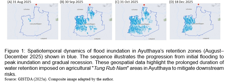
We examine water as a "socio-hydrological" entity shaped by technology and governance, described by Swyngedouw (2015). In Ayutthaya, designating land as a retention zone is a political act that subordinates the rural landscape to urban needs, reconfiguring the hydrosocial cycle. The spatial analysis of flood dynamics was supported by satellite-based imagery from the GISTDA Flood Monitoring System. Monthly inundation maps from August to December 2025 were composed to assess the temporal duration of water retention and its correlation with the agricultural calendar of the study area.
Urban-Rural Linkages (UN-Habitat)
The analysis employs the UN-Habitat’s Guiding Principles on Urban-Rural Linkages (UN-Habitat, 2019) as a normative standard, specifically emphasising Guiding Principles 2 (GP2: Integrated Governance) and 4 (GP4: Financial Inclusivity) to evaluate the equity dimensions of current policies.
The paper shows that the LS-NBS programme consistently results in risk transfer, leading to an uneven distribution of costs.
The designation of risk-bearing areas
Ayutthaya’s agricultural fields have effectively been designated as a permanent "hydrological buffer." This approach formalises the government’s emphasis on safeguarding urban and industrial areas rather than rural livelihoods. As a result, the land is valued primarily for its flood-mitigation role rather than for its primary function of food production. According to data from the Geo-Informatics and Space Technology Development Agency (GISTDA, 2025a), peak flooding on the west side of Ayutthaya occurred during October-November 2025, as shown in Figure 1. As of mid-November 2025, Ayutthaya remained the most severely affected province in the Lower Chao Phraya Basin, with 405,067 rai (approx. 64,811 ha) of land submerged. Satellite data distinguished between new runoff and prolonged stagnant water, highlighting the enduring nature of the flood in these retention zones (GISTDA, 2025b).
Floodwaters in Ayutthaya’s designated retention zones expand steadily from late September, peak through September and October, and begin to recede only in December. Field observations and local reports further indicate that, in several areas, water levels remained elevated into early January, underscoring the prolonged duration of inundation imposed on agricultural “Tung Rub Nam” landscapes.
Centralized governance and local disempowerment (GP2)
Decisions concerning water diversion timing and the activation of retention zones remain highly centralized. While farmers are consulted on technical specs in designated areas, they lack formal negotiation rights regarding planting cycles and harvesting schedules. This leads to an erosion of local agency and the marginalization of local ecological knowledge (Hongsprabhas, 2023).
Inadequate compensation and financial inequity (GP4)
The current compensation mechanism is reactive—framed as disaster relief—rather than systemic remuneration for an essential service (Hongsprabhas, 2023). These payments often fail to cover the full economic opportunity cost or the social disruption caused by state-mandated flooding.
DISCUSSION AND RECOMMENDATIONS
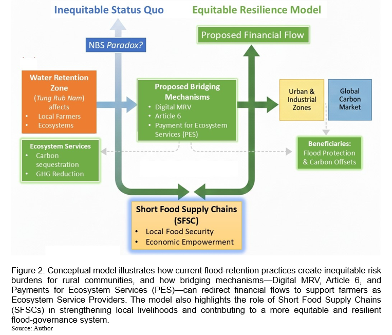
Figure 2 illustrates the shift, contrasting the unequal status quo with a proposed resilience model in which Digital Monitoring, Reporting and Verifying (MRV) system, Article 6, and PES act as bridging mechanisms to ensure that farmers are recognised and compensated as Ecosystem Service Providers.
Institutionalizing PES and Carbon Synergies via Article 6
The core requirement for equity in flood governance is recognizing farmers as active Ecosystem Service Providers (ESPs), moving beyond the traditional view of rural communities as passive recipients of flood management. As Thailand prepares for international carbon market cooperation through the Supporting Preparedness for Article 6 Cooperation (SPAR6C) programme, 'Tung Rub Nam' areas offer a strategic opportunity for repositioning. By integrating agroecological practices—such as carbon sequestration through flood-resilient landscapes or methane reduction via flexible Alternate Wetting and Drying (AWD)—these areas can become prime candidates for results-based financing under Articles 6.2 or 6.4 of the Paris Agreement. If structured to meet high-integrity standards for Internationally Transferred Mitigation Outcomes (ITMOs), this framework can prevent 'double counting' and establish a transparent, sustainable benefit-sharing mechanism.
The implementation of digital MRV (Monitoring, Reporting, and Verification) for flood-based carbon credits presents an opportunity to refine existing governance models in Southeast Asia. Rather than allowing technical metrics to unintentionally overshadow local socio-ecological nuances (Lau et al., 2025), a more inclusive data strategy can help ensure that benefit-sharing remains equitable and grounded in local realities.
In this context, Article 6 serves as a "Future Financial Catalyst," where a robust, government-led data infrastructure can unlock international climate finance and solidify Thailand’s regional leadership in climate action. By developing this infrastructure, the government can facilitate a strategic transition from a "reactive relief" model to a "proactive service-based" framework. This transition envisions flood management as a formal Service-based Contract, empowering authorities to systematically recognise and remunerate farmers' contributions as ESPs. Ultimately, this professionalized partnership enhances both administrative efficiency and long-term community resilience through a predictable and mutually beneficial cooperation.
Addressing the capacity gap and power asymmetry
Applying global mechanisms to local landscapes entails significant risks, primarily the technical barrier posed by Monitoring, Reporting, and Verification (MRV). If farmers cannot verify their own services, they remain dependent on external brokers who extract significant value.
- Capacity-building as equity: Systemic capacity-building is an urgent prerequisite for future readiness. Farmers must be trained not only in agroecology but also in digital traceability and basic carbon accounting. This shifts their role from "passive risk-bearers" to "informed market participants."
- Community-based MRV and data ownership: Given that international climate mechanisms are not yet fully operational in these floodplains, the focus must pivot toward 'Community-based MRV' models. By utilising low-cost digital tools, such as mobile GPS tracking and IoT soil sensors, farmers can independently document their ecosystem services. Empowering farmers as 'Data Owners' is a critical safeguard against the power asymmetry observed in regional carbon governance. This ensures that, as global cooperation expands into these landscapes, farmers are recognised as protected stakeholders.
To prevent 'Green Grabbing,' digital MRV must adopt a 'Farmer-in-the-Loop' architecture. This involves using decentralised ledgers in which soil carbon and nitrogen levels, as well as water retention durations, are timestamped directly by farmers using mobile-integrated IoT sensors. This 'Bottom-up Data Provenance' ensures that the metadata for ITMOs is owned by the community, creating a technical barrier for any centralized authority or intermediary seeking to claim carbon rights without local authorization.
Market Integration: Ethical Short Food Supply Chains (SFSCs)
From a food system’s perspective, transforming flood retention zones into equitable 'waterscapes' is essential for stabilising local agro-ecosystems and ensuring long-term food security. By integrating Short Food Supply Chains (SFSCs), the model moves beyond flood mitigation to actively support the socio-economic resilience of small-scale producers within the regional food value chain. Market-based approaches complement international financing by diversifying farmers' income and fostering urban-rural solidarity. Building on a previous agroecological framework for urban-rural linkages (Hongsprabhas, 2023), the synergy between carbon financing and local markets can be realized through an “Ethical Resilience Label” for agricultural products. Consumers in urban centres can directly fund rural resilience by paying a premium for flood-resilient' products, ranging from Glycemic Index or Geographical Indication (GI) rice to value-added agro-processed goods. This creates a 'Double Dividend'—combining local market premiums with global results-based payments. Such a branding strategy transforms farmers' socioeconomic status from risk-bearers to climate entrepreneurs, providing a robust financial cushion and fostering a dignified future for food producers in the region.
CONCLUSION
Ayutthaya’s experience reveals that climate adaptation can unintentionally deepen vulnerability by reallocating environmental costs. The solution lies in an ethical and institutional shift. By bridging local flood governance with global frameworks like Article 6, we can transform "sacrificial zones" into "model landscapes for equitable resilience." However, this transformation is only possible if we prioritise capacity-building and robust safeguards to prevent power asymmetries from turning global climate cooperation into a new form of rural exploitation. Affirming food producers as essential stewards of ecological services—armed with the knowledge and legal protection to defend their rights—is the only pathway to a sustainable and dignified future for Asia's river basins. While this paper provides a conceptual and evidence-informed foundation, the detailed institutional, economic, and legal analyses required for implementation fall beyond its scope. These will be the essential next steps for policymakers and relevant agencies.
ACKNOWLEDGEMENTS
The author acknowledges that, although the foundational context of Ayutthaya’s flood zones is shared with the author’s concurrent empirical survey-based research, this paper offers a distinct and novel policy synthesis. It advances the discussion by integrating international climate finance frameworks (Article 6).
REFERENCES
Anguelovski, I. (2015). From toxic sites to parks as (green) LULUs? New challenges of inequity, privilege, gentrification, and exclusion for urban environmental justice. Journal of Planning Literature, 31(1), 23–36. https://doi.org/10.1177/0885412215610491
Ayutthaya Provincial Office. (2021). Ayutthaya provincial development plan (2023–2027). [In Thai].
Geo-Informatics and Space Technology Development Agency. (2025a). GISTDA flood monitoring system: Spatiotemporal analysis of flood inundation and water retention dynamics in the Lower Chao Phraya Basin. Ministry of Higher Education, Science, Research and Innovation. https://disaster.gistda.or.th/flood
Geo-Informatics and Space Technology Development Agency. (2025b, November 13). GISTDA reveals THEOS-1 satellite imagery of flooding in Ayutthaya, Ang Thong, Suphan Buri, and Nakhon Pathom, covering over 813,817 rai. https://www.gistda.or.th/news_view.php?n_id=8926&lang=TH
Harvey, D. (1996). Justice, nature and the geography of difference. Blackwell Publishers.
Hongsprabhas, P. (2023). Agroecology and climate change: Urban-rural linkages for food system resilience in Thailand’s Lower Chao Phraya Basin. Frontiers in Sustainable Cities, 5, 1193356. https://doi.org/10.3389/frsc.2023.1193356
Lau, Y., Kenney-Lazar, M., Marks, D. & et al. (2025). Challenges in forest carbon governance: Insights from Southeast Asia. WIREs Climate Change, 16(5), e70018. https://doi.org/10.1002/wcc.70018
Swyngedouw, E. (2015). Urbanization and environmental imaginaries. In T. A. Perreault, G. Bridge, & J. McCarthy (Eds.), The Routledge handbook of political ecology. Routledge.
UN-Habitat. (2019). Urban-rural linkages: Guiding principles. United Nations Human Settlements Programme.
United Nations. (2015). Transforming our world: The 2030 Agenda for Sustainable Development. UN Publishing.
Van Buuren, A., Ellen, G. J., & Warner, J. F. (2016). Path-dependency and policy learning in the Dutch delta: Toward more resilient flood risk management in the Netherlands? Ecology and Society, 21(4), 43. https://doi.org/10.5751/ES-08765-210443
Zhao, Y., & Trowsdale, S. (2025). The many faces of China’s Sponge City Initiative. Frontiers in Sustainable Cities, 7, 1688283. https://doi.org/10.3389/frsc.2025.168828


Distribution of Risk and Ecosystem Service in Flood-retention Zones of Thailand
ABSTRACT
Across Asia, climate adaptation strategies that involve large-scale infrastructure and Nature-Based Solutions (NBS) often result in an uneven distribution of risks and benefits. This research examines the designation of agricultural land in western Ayutthaya, Thailand, as designated flood retention zones (Tung Rub Nam) under the national Large-Scale NBS (LS-NBS) programme. Using frameworks of socio-ecological governance and socio-hydrological dynamics, this study analyzes how centralized flood management is constrained in its capacity to support local livelihoods. Findings suggest that the current compensation model imposes a "risk-bearing" burden on rural communities to safeguard urban capital. The article advocates for a paradigm shift towards ethical flood governance through the implementation of Payments for Ecosystem Services (PES) and the promotion of Short Food Supply Chains (SFSCs). Additionally, it explores the potential of international climate cooperation frameworks, such as Article 6 of the Paris Agreement, to establish reliable financial mechanisms to reward farmers as Ecosystem Service Providers (ESPs). Nonetheless, the study also notes that, without comprehensive capacity-building and safeguards against power asymmetries, these global mechanisms may reproduce extractive patterns like those seen in forest carbon governance. While the analysis provides a conceptual and evidence-informed foundation, operationalizing these approaches will require further institutional and economic assessments by policymakers.
Keywords: Article 6, ecosystem service providers (ESPs), flood governance equity, nature-based solutions (NBS), and socio-hydrology
INTRODUCTION
Promoting the transformation of vulnerable communities into “sustainable human settlements” requires systematic urban–rural integration aligned with the United Nations Sustainable Development Goals (SDGs), which emphasise reducing inequality, strengthening economic cooperation, and safeguarding the environment (United Nations, 2015). However, integrated development frameworks must be adapted to the socio-ecological complexity of specific localities to ensure that community needs are genuinely addressed.
Phra Nakhon Si Ayutthaya (Ayutthaya for short) is the selected area of focusin this paper due to its unique role in Thailand's national flood management hierarchy and its complex socio-ecological significance. Firstly, Ayutthaya represents a critical cultural and economic core; the preservation of the Ayutthaya Island (Koh Muang)—a UNESCO World Heritage site—is a non-negotiable priority for the national government. This necessitates a "protective diversion" policy that redirects floodwaters away from the historic urban centre and into the surrounding agricultural plains. Secondly, the province’s physical geography, characterised by a noticeably flat terrain, naturally supports the accumulation of runoff from the northern provinces. This natural depression is complemented by a highly engineered irrigation network. The system of transverse and longitudinal canals already exists to direct water flow from the urban core towards designated retention fields, namely Tung Rangsit in the east and Tung Chao Chet in the west. This infrastructure enables authorities to retain large volumes of water before it moves further south and threatens Pathum Thani and Bangkok. This study considers Ayutthaya as a strategic microcosm for analysing the global challenge of equitable climate adaptation. It is a location where safeguarding global heritage and national economic capital is directly supported by the managed inundation of rural landscapes, making it an ideal site for developing a more ethical and proactive service-based flood governance model.
In Ayutthaya Province, agriculture occupies 883,024 rai (approx. 141,283.84 Ha)—over half of the total land area—yet the provincial economy is increasingly driven by industry rather than farming (Ayutthaya Provincial Office, 2021). This shift has diminished the policy recognition of western Ayutthaya’s agricultural floodplains, despite their critical role in national food security.The intensification of climate change necessitates robust disaster risk reduction strategies, particularly in densely populated Asian river basins were urban and industrial growth overlap with vital agricultural production. While Nature-Based Solutions (NBS) are widely promoted for their ecological benefits, their implementation often involves complex political decisions about who bears the cost of resilience (Anguelovski, 2016).
The western floodplain in Ayutthaya is not only a fertile agricultural landscape but also a hydrosocial space shaped by collective memory and enduring power relations. Flood governance here cannot be understood solely through technical frameworks; it demands historical and cultural interpretation that links geography, community memory, and state authority. The 2011 mega-flood in Thailand exposed the systemic vulnerabilities of the Lower Chao Phraya Basin. In response, the state designated critical agricultural floodplains in Ayutthaya as compulsory flood retention zones. This state-led intervention highlights the "NBS Equity Challenge," where macro-level resilience—such as protecting industrial estates and the Bangkok Metropolitan Area—creates social trade-offs and structural challenges for rural communities. This phenomenon echoes global trends, such as the social impacts observed in the Netherlands’ "Room for the River" programme (Van Buuren et al., 2016) and the centralized control paradoxes in China's Sponge Cities (Zhao & Trowsdale, 2025).
While major regional players like China have pioneered NBS through the Sponge City initiative to improve urban flood resilience, the socio-economic implications for peri-urban and rural landscapes remain a vital area for policy development. Across the Mekong River Basin, increased hydrological variability increasingly endangers smallholder rice farming systems, which form the backbone of regional food security.
Ayutthaya’s water retention zone, 'Tung Rub Nam,' serves as a local yet highly strategic microcosm of this broader regional challenge, in which the success of large-scale climate adaptation depends on the equitable recognition of rural communities' roles in managing transboundary water risks. The present study pathways and institutional power structures. Using a food studies approach that integrates science, the humanities, history, and social critique, this study examines a key question: How does centralized flood governance influence socio-economic challenges in farming communities, and what institutional mechanisms can help restore equity?
Flood-retention zones of Ayutthaya province
This policy paper proposes a transformative framework for equitable flood governance in Thailand, with a focus on enhancing the socio-economic resilience of agricultural communities in the Lower Chao Phraya Basin. The objective of this paper is to explore these dynamics by employing a political-ecological approach, viewing environmental changes—such as managed inundation—not merely as natural events but as outcomes of power relations and the strategic distribution of resources (Harvey, 1996). To achieve this, the paper aims to:
Socio-hydrological dynamics
We examine water as a "socio-hydrological" entity shaped by technology and governance, described by Swyngedouw (2015). In Ayutthaya, designating land as a retention zone is a political act that subordinates the rural landscape to urban needs, reconfiguring the hydrosocial cycle. The spatial analysis of flood dynamics was supported by satellite-based imagery from the GISTDA Flood Monitoring System. Monthly inundation maps from August to December 2025 were composed to assess the temporal duration of water retention and its correlation with the agricultural calendar of the study area.
Urban-Rural Linkages (UN-Habitat)
The analysis employs the UN-Habitat’s Guiding Principles on Urban-Rural Linkages (UN-Habitat, 2019) as a normative standard, specifically emphasising Guiding Principles 2 (GP2: Integrated Governance) and 4 (GP4: Financial Inclusivity) to evaluate the equity dimensions of current policies.
The paper shows that the LS-NBS programme consistently results in risk transfer, leading to an uneven distribution of costs.
The designation of risk-bearing areas
Ayutthaya’s agricultural fields have effectively been designated as a permanent "hydrological buffer." This approach formalises the government’s emphasis on safeguarding urban and industrial areas rather than rural livelihoods. As a result, the land is valued primarily for its flood-mitigation role rather than for its primary function of food production. According to data from the Geo-Informatics and Space Technology Development Agency (GISTDA, 2025a), peak flooding on the west side of Ayutthaya occurred during October-November 2025, as shown in Figure 1. As of mid-November 2025, Ayutthaya remained the most severely affected province in the Lower Chao Phraya Basin, with 405,067 rai (approx. 64,811 ha) of land submerged. Satellite data distinguished between new runoff and prolonged stagnant water, highlighting the enduring nature of the flood in these retention zones (GISTDA, 2025b).
Floodwaters in Ayutthaya’s designated retention zones expand steadily from late September, peak through September and October, and begin to recede only in December. Field observations and local reports further indicate that, in several areas, water levels remained elevated into early January, underscoring the prolonged duration of inundation imposed on agricultural “Tung Rub Nam” landscapes.
Centralized governance and local disempowerment (GP2)
Decisions concerning water diversion timing and the activation of retention zones remain highly centralized. While farmers are consulted on technical specs in designated areas, they lack formal negotiation rights regarding planting cycles and harvesting schedules. This leads to an erosion of local agency and the marginalization of local ecological knowledge (Hongsprabhas, 2023).
Inadequate compensation and financial inequity (GP4)
The current compensation mechanism is reactive—framed as disaster relief—rather than systemic remuneration for an essential service (Hongsprabhas, 2023). These payments often fail to cover the full economic opportunity cost or the social disruption caused by state-mandated flooding.
DISCUSSION AND RECOMMENDATIONS
Figure 2 illustrates the shift, contrasting the unequal status quo with a proposed resilience model in which Digital Monitoring, Reporting and Verifying (MRV) system, Article 6, and PES act as bridging mechanisms to ensure that farmers are recognised and compensated as Ecosystem Service Providers.
Institutionalizing PES and Carbon Synergies via Article 6
The core requirement for equity in flood governance is recognizing farmers as active Ecosystem Service Providers (ESPs), moving beyond the traditional view of rural communities as passive recipients of flood management. As Thailand prepares for international carbon market cooperation through the Supporting Preparedness for Article 6 Cooperation (SPAR6C) programme, 'Tung Rub Nam' areas offer a strategic opportunity for repositioning. By integrating agroecological practices—such as carbon sequestration through flood-resilient landscapes or methane reduction via flexible Alternate Wetting and Drying (AWD)—these areas can become prime candidates for results-based financing under Articles 6.2 or 6.4 of the Paris Agreement. If structured to meet high-integrity standards for Internationally Transferred Mitigation Outcomes (ITMOs), this framework can prevent 'double counting' and establish a transparent, sustainable benefit-sharing mechanism.
The implementation of digital MRV (Monitoring, Reporting, and Verification) for flood-based carbon credits presents an opportunity to refine existing governance models in Southeast Asia. Rather than allowing technical metrics to unintentionally overshadow local socio-ecological nuances (Lau et al., 2025), a more inclusive data strategy can help ensure that benefit-sharing remains equitable and grounded in local realities.
In this context, Article 6 serves as a "Future Financial Catalyst," where a robust, government-led data infrastructure can unlock international climate finance and solidify Thailand’s regional leadership in climate action. By developing this infrastructure, the government can facilitate a strategic transition from a "reactive relief" model to a "proactive service-based" framework. This transition envisions flood management as a formal Service-based Contract, empowering authorities to systematically recognise and remunerate farmers' contributions as ESPs. Ultimately, this professionalized partnership enhances both administrative efficiency and long-term community resilience through a predictable and mutually beneficial cooperation.
Addressing the capacity gap and power asymmetry
Applying global mechanisms to local landscapes entails significant risks, primarily the technical barrier posed by Monitoring, Reporting, and Verification (MRV). If farmers cannot verify their own services, they remain dependent on external brokers who extract significant value.
To prevent 'Green Grabbing,' digital MRV must adopt a 'Farmer-in-the-Loop' architecture. This involves using decentralised ledgers in which soil carbon and nitrogen levels, as well as water retention durations, are timestamped directly by farmers using mobile-integrated IoT sensors. This 'Bottom-up Data Provenance' ensures that the metadata for ITMOs is owned by the community, creating a technical barrier for any centralized authority or intermediary seeking to claim carbon rights without local authorization.
Market Integration: Ethical Short Food Supply Chains (SFSCs)
From a food system’s perspective, transforming flood retention zones into equitable 'waterscapes' is essential for stabilising local agro-ecosystems and ensuring long-term food security. By integrating Short Food Supply Chains (SFSCs), the model moves beyond flood mitigation to actively support the socio-economic resilience of small-scale producers within the regional food value chain. Market-based approaches complement international financing by diversifying farmers' income and fostering urban-rural solidarity. Building on a previous agroecological framework for urban-rural linkages (Hongsprabhas, 2023), the synergy between carbon financing and local markets can be realized through an “Ethical Resilience Label” for agricultural products. Consumers in urban centres can directly fund rural resilience by paying a premium for flood-resilient' products, ranging from Glycemic Index or Geographical Indication (GI) rice to value-added agro-processed goods. This creates a 'Double Dividend'—combining local market premiums with global results-based payments. Such a branding strategy transforms farmers' socioeconomic status from risk-bearers to climate entrepreneurs, providing a robust financial cushion and fostering a dignified future for food producers in the region.
CONCLUSION
Ayutthaya’s experience reveals that climate adaptation can unintentionally deepen vulnerability by reallocating environmental costs. The solution lies in an ethical and institutional shift. By bridging local flood governance with global frameworks like Article 6, we can transform "sacrificial zones" into "model landscapes for equitable resilience." However, this transformation is only possible if we prioritise capacity-building and robust safeguards to prevent power asymmetries from turning global climate cooperation into a new form of rural exploitation. Affirming food producers as essential stewards of ecological services—armed with the knowledge and legal protection to defend their rights—is the only pathway to a sustainable and dignified future for Asia's river basins. While this paper provides a conceptual and evidence-informed foundation, the detailed institutional, economic, and legal analyses required for implementation fall beyond its scope. These will be the essential next steps for policymakers and relevant agencies.
ACKNOWLEDGEMENTS
The author acknowledges that, although the foundational context of Ayutthaya’s flood zones is shared with the author’s concurrent empirical survey-based research, this paper offers a distinct and novel policy synthesis. It advances the discussion by integrating international climate finance frameworks (Article 6).
REFERENCES
Anguelovski, I. (2015). From toxic sites to parks as (green) LULUs? New challenges of inequity, privilege, gentrification, and exclusion for urban environmental justice. Journal of Planning Literature, 31(1), 23–36. https://doi.org/10.1177/0885412215610491
Ayutthaya Provincial Office. (2021). Ayutthaya provincial development plan (2023–2027). [In Thai].
Geo-Informatics and Space Technology Development Agency. (2025a). GISTDA flood monitoring system: Spatiotemporal analysis of flood inundation and water retention dynamics in the Lower Chao Phraya Basin. Ministry of Higher Education, Science, Research and Innovation. https://disaster.gistda.or.th/flood
Geo-Informatics and Space Technology Development Agency. (2025b, November 13). GISTDA reveals THEOS-1 satellite imagery of flooding in Ayutthaya, Ang Thong, Suphan Buri, and Nakhon Pathom, covering over 813,817 rai. https://www.gistda.or.th/news_view.php?n_id=8926&lang=TH
Harvey, D. (1996). Justice, nature and the geography of difference. Blackwell Publishers.
Hongsprabhas, P. (2023). Agroecology and climate change: Urban-rural linkages for food system resilience in Thailand’s Lower Chao Phraya Basin. Frontiers in Sustainable Cities, 5, 1193356. https://doi.org/10.3389/frsc.2023.1193356
Lau, Y., Kenney-Lazar, M., Marks, D. & et al. (2025). Challenges in forest carbon governance: Insights from Southeast Asia. WIREs Climate Change, 16(5), e70018. https://doi.org/10.1002/wcc.70018
Swyngedouw, E. (2015). Urbanization and environmental imaginaries. In T. A. Perreault, G. Bridge, & J. McCarthy (Eds.), The Routledge handbook of political ecology. Routledge.
UN-Habitat. (2019). Urban-rural linkages: Guiding principles. United Nations Human Settlements Programme.
United Nations. (2015). Transforming our world: The 2030 Agenda for Sustainable Development. UN Publishing.
Van Buuren, A., Ellen, G. J., & Warner, J. F. (2016). Path-dependency and policy learning in the Dutch delta: Toward more resilient flood risk management in the Netherlands? Ecology and Society, 21(4), 43. https://doi.org/10.5751/ES-08765-210443
Zhao, Y., & Trowsdale, S. (2025). The many faces of China’s Sponge City Initiative. Frontiers in Sustainable Cities, 7, 1688283. https://doi.org/10.3389/frsc.2025.168828