ABSTRACT
Precision Agriculture (PA) is a key component of the agricultural digitization and means to apply the exact and correct amount of inputs like water, fertilizers, pesticides etc. at the correct time to the crop for increasing its productivity and maximizing its yields. It provides farmers with information to build up a record of their farms, helps to make decisions, promotes traceability and provides better marketing of farm products. Finally, it enhances the quality of the product itself. Rice production plays an important role in food security, rural employment, and foreign exchange in Vietnam as rice contributes to around 50% of the gross production of food crops. However, the technology development in the rice production in Vietnam is still in its infancy stage. The digitalization has not reached Vietnam’s rice sector yet. Most of Vietnamese rice farmers still use their own experiences as well as recommendations from research and extension services to undertake activities in seed selection, land preparation, crop management, irrigation and harvest. They are also still using basic computers, standard internet information and basic information and communications technology in general. The recently integrated rice crop management systems or precision rice-farming system, which starts to be adapted to the social and economic conditions in Vietnam, are promising for effective input use, increased productivity and improved farm profits. A growing number of farmers are starting to adopt information technology/digital technology and data-driven innovations. The paper will highlight some results of agriculture precision application in rice production in Vietnam.
Keywords: precision agriculture, rice production, information technology, crop manager, Vietnam
INTRODUCTION
Rice production has played an important role in food security, rural employment, and foreign exchange in Vietnam. Rice is the most important food crop in Vietnam and accounts for around 50% of gross production of other food crops (GSO, 2018). Although the planted rice area harvested just expanded from 6.8 million ha in 1995 to 7.5 million ha in 2015 (GSO, 2018), the use of input-responsive modern varieties, sufficient fertilizers, and an increase in the proportion of irrigated rice areas (93.4%) account for the high yields in recent decade. Since then, Vietnam has continuously increased rice production to become the second largest rice exporter worldwide in 2012 (GSO, 2018). The Mekong Delta alone, which is often called “Vietnam’s Rice Bowl” contains the majority of the area designated for rice agriculture, yields 54% of the national rice production and contributes to the 95% of rice exports in Vietnam, which accounts for 4.7 million tons of rice every year (IRRI- Ricepedia, 2018). It not only feeds a population of 95 million (GSO, 2018) but also provides food security in Southeast Asia. According to the topography, soil, and climate conditions, agricultural activity can be divided into eight agricultural ecological sections but much of the rice cultivation is concentrated in two river deltas: the Mekong (over half of the country’s rice area) and Red River Delta.
Like in many developing countries, there is no specific precision agriculture/farming system programme – there is a shortage of capital, knowledge and technologies. Nevertheless, improved agricultural management is practiced in Vietnam, exploiting available means and resources to increase agricultural productivity and production. In rice production systems, farmers in Vietnam use their own experiences as well as recommendations from research and extension services to undertake activities in seed selection, land preparation, crop management, irrigation and harvest. The recently developed integrated rice crop management systems or precision farming system (Global Positioning System, Remote Sensing Technologies,, Variable-Rate Technologies, Grain Yield Monitors for Mapping etc…) , which start to be adapted to the social and economic conditions in Vietnam, are promising for effective input use, increased productivity and improved farm profits.
THE RICE CROP MANAGER (RCM): ICT-APPLICATION FOR SMART-RICE PRODUCTION IN VIETNAM
The improvement of crop management practices among small rice farmers in developing countries with small farm size, including Vietnam, is often not an easy task. Crop management practices must be adjusted to crop varieties, environmental factors, knowledge and market forces. Input and output prices affect farmers’ decisions with regard to the level of inputs to be applied, while employment opportunities influence the time spent by farmers in crop management. The improvement of farmers’ management skills through the accumulation of data and information is an important aspect of precision farming system and it has been integrated into the development and dissemination of rice crop management (RCM) in a number of rice-producing countries like Vietnam. Site-specific rice crop management allows inputs to be reduced, while optimizing outputs, both of which are attractive to the farm producers. At the same time, by reducing inputs, the run-off of fertilizers and pesticides is reduced, thus improving the environmental condition of the agro-ecosystem .
Rice Crop Manager (RCM), a web-based application available on smart phones have been developed by IRRI, is specifically designed for rice farmers to guide them in nutrient management as well as other cultural management practices. The RCM enables agricultural extension staff to ensure sustainable productivity gains for poor rice farmers through cost-effective crop management practices. Information and Communication Technologies (ICTs) plays an increasingly important role in making agricultural advisory scalable and accessible to large numbers of farmers, while providing timely and farm-specific information to support farmers’ farmland crop management decisions. The use of the app is free. This cost-saving application is a step towards precision farming. Farmers will be informed as to what specific fertilizer to use, when to use it and at how much quantity. They are also given guides as to seeding rate, water and weed management. The RCM uses results of research and existing knowledge to provide farmers with ‘precise’ field- and farmer-specific recommendations and uses advances in ICTs to provide professional extension and advisory services.

Figure 1: Vietnamese Version of The Rice Crop Manager
RCM tested regionally at the Mekong River Delta and Red River Delta of Vietnam through an collaborative project between IRRI and Cuu Long Rice Research Institute and Soils and Fertilizers Research Institute (2 member institutions under Vietnam Academy of Agricultural Sciences (VAAS)).IRRI and VAAS are also partnering to develop a project with national support for the development testing, endorsement, release, and dissemination of Rice Crop Manager in the Mekong Delta and Red River Delta. This project aims to (1) develop beta versions of Rice Crop Manager mobile apps customized for the cropping systems of the Mekong Delta and Red River Delta, 2 major rice-growing areas of Vietnam programmed in HTML5 and accessible athttp://webapps.irri.org/vn/rcm; and (2) incorporate new modules on adjusted rice management practices into a new decision tool called CIRCLE (Climate-Informed Rice Crop and Low Emission), supplementing the output of Rice Crop Manager with preliminary estimates of greenhouse gas emissions.
This project will build on past collaborative IRRI-Vietnam research, which resulted in the initial development of Nutrient Manager for Rice where IRRI has already developed. It started the development of Rice Crop Manager from the preliminary Nutrient Manager for Rice. The beta version of the Rice Crop Manager (RCM) mobile application customized for the cropping systems of the Mekong Delta and Red River Delta was developed. It is accessible at http://webapps.irri.org/vn/rcm. It underwent pre-testing in February 2015 in Bac Lieu Province.
A beta version of CIRCLE Manager, using IPCC published guidelines for estimating methane and nitrous oxide emissions, was integrated into the RCM for the Mekong Delta. Information obtained from the CLUES project and the climate-smart village (CSV) in Bac Lieu was used to fine-tune the RCM and CIRCLE Manager for the Mekong Delta. Partnerships were initiated to enable testing at the CSV in Bac Lieu starting in February 2015. Another blueprint, which is feasible with the current configuration of RCM but not yet implemented, is to enable the use of CIRCLE Manager at the end of the cropping season to calculate the estimated greenhouse gas emissions for the water and crop management practices actually used by the farmer.
Late in 2014, the pre-scaling and testing process of the RCM has started for both the Mekong River and Red River deltas in the Northern and Southern parts of Vietnam. To date, two beta versions in Vietnamese have been completed for the RCM basic features and are now being tested through Randomized Controlled Trials (RCTs) by 96 farmers, of which 30 are women, under the guidance of the provincial Department of Agriculture and Rural Development (DARD). Data on optimal input use and maximization of yields is collected and compared with farmers’ current practices (control group). 12 farmers and 4 women farmers are testing the RCM in an LSRF in the Province of Bac Lieu in collaboration with Better-Rice-Initiative-Asia (BRIA). There will be 3 replications of the RCTs over 3 rice cropping season. The results from field testing in Mekong River and Red River deltas shown that farmers increased net income in 4 out of 5 seasons by switching to the recommended practices of RCM
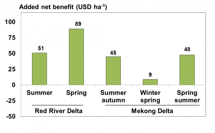
Figure 2: Added net benefit from field-pilot RCM application in Vietnam
Field research has shown yields targeted by RCM were achieved or exceeded in winter-spring. It appears that RCM set N fertilizer rates too low for the target yield in winter-spring. Improvement in setting of location- and season-specific yield targets is still feasible.
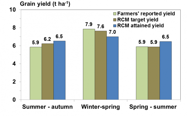
Figure 3: Rice grain yield comparison at field-pilot RCM application in Vietnam
After 2 years of piloting in Dong Thap, Hau Giang and Long An, RCM app proved suitable for Mekong Delta farmers. According to IRRI experts and the users themselves, RCM has "fairly" advised farmers about the diet for rice as well as the way to take care of rice in accordance with weather conditions and the pest management. If in the past, most farmers cultivated rice based on subjective experience, after using RCM, the application helped them improve cultivation efficiency, save fertilizer and nutrients for rice but still achieving good productivity. RCM can be adopted in other localities, especially the provinces with a large area of rice cultivation such as An Giang to improve production efficiency, reduce costs and increase income for farmers, to help farmers become gradually familiar with smart production management ...
The RCM in Vietnam also includes new features on Climate Smart Agriculture (CSA). These will gradually move the RCM from its basic crop management functions, such as forecasted yields based on appropriate fertilizer use, to a broader advisory service platform. The existing greenhouse gases (GHG) calculator for a targeted rice field will, in the next future, will be able to calculate emission reductions when technologies such as Alternate Wetting and Drying (AWD) or different straw management practices are adopted by farmers. Before the end of the year, a CSA agro-advisory service will start delivering SMS on short range and extended weather forecasts and related agromet advice to rice growers’ mobile phones. This system helps farmers to know which yields are tobe expected in a specific climate context at different rice growth stages.
The RCM also has attracted huge interest from government and private partners, who play important role for its out-and up-scaling such as MARD, NAEC, PetroVietnam Fertilizer and Chemicals Corporation (PVFCCo). IRRI obtained support from PVFCCo for field research in the Mekong Delta for 2015 to evaluate and refine the fertilizer recommendation in RCM and to promote RCM. RCM was additionally enhanced to enable the setting of climate-adjusted yields based on Oryza crop simulations using historical climate data and seasonal climate forecasts. The testing, verifying, promoting, and disseminating of the updated beta version of RCM and CIRCLE Manager have been delayed to 2015.
An additional support tool, targeted to be introduced by the end of 2015, is the ‘Seed Selector’ that helps farmers to choose the most suitable seed varieties considering production objectives, field conditions and investment potential. The software automatically selects three best seed variety options and their sources. The most recent development planned is an application that supports affected rice growers dealing with salinity intrusion in rice fields in the coastal provinces of the Mekong river delta. Affected farmers are selected from areas that are known from the GIZ
Integrated Coastal Management Program (ICMP) in the salinity belt of the Bac Lieu and Hau Giang provinces. SALTS (Salinity Advisory as a Location specific Timely Service) advisory will be integrated into the RCM platform and complement the current ICMP activities for the dissemination of salt-tolerant rice varieties. ICMP is expected to play a pivotal role in knowledge sharing at national level and among provincial partners about these new RCM advisory services.
OPERATIONAL SPATIAL DATA-BASED RICE MONITORING SYSTEM IN VIETNAM
The precision farming system employs the innovations and new technologies including Geographic Information Systems (GIS), Global Positioning Systems (GPS) and Remote Sensing (RS) technologies to allow farm producers to manage within field variability to maximize the cost-benefit ratio, rather than using the traditional whole-field approach. Variable Rate Technology (VRT) available with farm implements, such as fertilizer or pesticide applicators and yield monitors, has evolved rapidly and has fostered the growth of precision agriculture. Remote Sensing (RS) provides input data for many precision agriculture applications including pre-growth soil fertility and moisture analyses, crop growth and growth detract ant monitoring (crop scouting), and yield forecasting. Remote sensing data might provide quick high-quality, consistent, and timely information about spatial and temporal changes in the rice cropping area in different seasons on regional and global scales
In Vietnam, rice monitoring using remote sensing has received great attention from managers and researchers. The remote sensing of rice-growing areas can not only contribute to the precise mapping of rice areas and the assessment of the dynamics in rice-growing regions, but can also contribute to harvest prediction modelling, the analyses of plant diseases, the assessment of rice-based greenhouse gas (methane) emission due to vegetation submersion, the investigation of erosion-control-adapted agricultural systems, and the assessment of ecosystem services in rice-growing areas. Effective rice monitoring is essential for supporting policy making with accurate information concerning rice-growing areas, estimation of production, and seasonal cropping patterns to achieve increased economic development and food security. Therefore, a number of rice monitoring projects have been implemented in Vietnam.
There are so many studies of rice crop monitoring using remote sensing data has been implemented in the Mekong Delta. Recently in 2015, Caitlin Kontgis et al (2015) used Landsat-5/7/8 image data to map rice paddy extent and intensification in the Mekong River Delta. The results show that this method can map rice paddies with over 90% overall accuracy (and errors of omission and commission ranging from 6 to 25%) at a finer spatial resolution than previous efforts. C.F. Chen et al (2016) used using Sentinel-1A phenological metrics to build rice maps in the Mekong Delta region with an accuracy of 86.2% . In addition, Kirsi Karila et al (2014) combined data of ENVISAT radar, Landsat and SPOT optical images to separate rice planting area from aquaculture and fruit trees planting area with an overall accuracy of 80%. Besides, Nguyen Dang Vy (2014) also used MODIS image with an 8-day regular repeat cycle to apply for the management of rice production in the Mekong Delta. It provides the capability to centrally, reveals on its map details of each ward, each farm and each paddy field according to demand of each local area. Together yet independent from data received by each local place is the picture data produced by MODIS satellite, with new method of rice recognition and updates regularly, allows rice sowing process monitoring of each paddy field, determines rice stages on ricefields, report on rice health and predicts rice productivity [22]. Similar to studies in other regions of the world, the method used in Vietnam also focuses on studying the growth characteristics of rice so as to determine the appropriate thresholds for specific indicators (NDVI/EVI) to separate rice from other types of plantation.
The rice monitoring project of the Ministry of Agriculture and Rural Development in 1999 was one of the pioneering steps in using satellite images to monitor the crop production. The project marks a significant milestone for the cooperation between Vietnam's northern and southern research institutes as well as direct connection to provincial agencies in the Mekong Delta. The group provided the Ministry of Agriculture with 20 RADARSAT-1 satellite images that collected in the Mekong Delta in the summer rice cropping season1999/2000.
From 2013-2015, Vietnam joins Asia Rice Crop Estimation and Monitoring (Asia-RiCE) initiative that aims at improving operational rice crop monitoring and estimation using Earth observations in the Asian region. The Asia-RiCE initiative (http://www.asia-rice.org) has been organized to enhance rice production estimates through the use of Earth observation, and seeks to ensure that Asian rice crops are appropriately represented within GEOGLAM. his work was conducted over Asian 100x100km Technical Demonstration Sites (TDS) with satellite –based cultivated area and growing stage maps generated. Asia-RiCE is composed of national teams that are actively contributing to the Crop Monitor for AMIS. These teams are working to develop technical demonstrations of rice crop monitoring activities using both Synthetic Aperture Radar (SAR) data and optical imagery (such as from MODIS, SPOT-5, Landsat, and Sentinel-2). The Asia-RiCE teams are also developing satellite-based agro-met information for rice crop outlook, crop calendars and damage assessment in cooperation with ASEAN Food Security Information System (AFSIS) for selected countries (currently Indonesia, Thailand, Vietnam and Japan. Asia-RiCE team members studied the TDS to estimate rice planted area, growing status, and damage area using time series SAR data from multiple providers in Indonesia, Vietnam, Thailand, Japan and others. The CESBIO team worked to define standard ground observation data collection method and developed rice monitoring methods using Sentinel-1 time series, under the GEORICE project funded by ESA, in cooperation with VAST, Vietnam (GEOLAM, 2018)
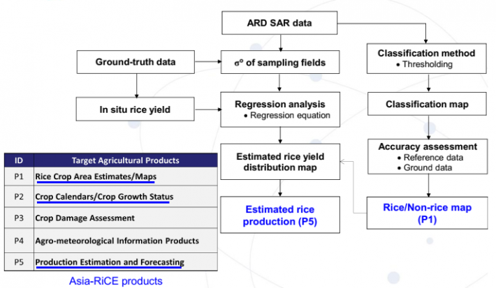
Figure 4: Schematic diagram of the rice monitoring method under Asia-RiCE project (Lam Dao Nguyen et al, 2018)
Following up Asia-RiCE, Vietnam’s implementing a new research project on applied research on the multi-temporal, multi-resolution optical and radar remote sensing data for rice planted area monitoring and rice yield, production estimation in the Mekong Delta and Red River Delta (VNRice project, 2017-2020). The project aims to evaluate the use of remote sensing data in rice monitoring and yield estimation, towards an operational system for rice crop inventory in Vietnam. The expected outputs are rice crop area maps, yield & production estimation, rice cropping calendars and crop growth status.
Recently, the Vietnam-Netherlands collaborative project (Sat4Rice) have been implementing in the Mekong River Delta, one of the largest rice producing regions in the world, fulfilling an important role in global food security. Sat4Rice (satellite data for rice producers) aims to improve rice production in the whole Mekong Delta, by providing satellite data driven information services. These information services increase the effectiveness of existing extension services to smallholder rice farmers. Loc Troi Group’s (LTG) extension workers, the ‘Farmers Friends’, are provided with near real-time data on production, inputs and environmental factors. Satellite data and field observations are integrated in a geodata platform, that is accessible through a browser-based smart phone app (progressive web app). This raises awareness, builds resilience of local communities and improves the efficiency of inputs for rice production in the Mekong delta such as water, fertilizers and pesticides. The project aims to reach a minimum of 300,000 smallholder rice farmers in the Mekong Delta, particularly in the An Giang and Soc Trang provinces. After the project, the service will be scaled-up further, to reach millions of rice farmers in the Mekong Delta and beyond. Sat4Rice achieves a strong business proposition by adding value on multiple places in the value chain. Farmers’ income increases due to improved rice farming conditions, whereas rice processors (like LTG) benefit from more efficient logistics and use of resources. Partners in the value chain profit from the extensive and detailed agricultural database of Sat4Rice. Key indicators are calculated every day, using latest satellite images and field observations. This provides the information services (Field characteristics and administrative data; Rice growth monitoring, forecast and use of inputs; Pest and diseases observations and risks; Flood monitoring and field preparation) to all value chain partners. After the project, the Sat4Rice information services are provided by Loc Troi Group, with technical support from the consortium partners. Additionally, Sat4Rice is exploring further collaboration with value chain partners in sustainable rice production to strengthen its impact on the sector and extend its reach, potentially to other commodities such as coffee (G4AW, 2018).
In the North of Vietnam, the project "Monitoring rice production in the Red River Delta using remote sensing data" was carried out by the Center for Remote Sensing and GIS, the National Institute of Agriculture Planning and Projection. With the use of MODIS satellite images, rice production in the Red River Delta has been updated regularly. Planting areas as well as rice harvesting time are analyzed from satellite images, allowing managers to continuously monitor production in the area. The model of rice yield is based on linear regression data reported by the local departments from 2007 to present, combining the vegetation index, environmental index, water surface, heat ... allows early forecast of yield and yield of each crop, time 1 month before harvest. However, the project has ended and has stopped providing new, updated rice maps for the Red River Delta in recent years.
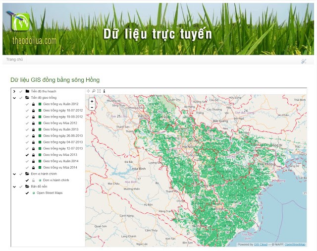
Figure 5: The website of monitoring rice production in the Red River Delta using remote sensing data
The website of the project is located at http://www.theodoilua.com (Figure…). The main products of the project are published in including:
- Set of maps to monitor the progress of rice cultivation
- Set of maps to track the progress of rice harvest
- Set of maps to monitor rice growing status
- Set of maps to monitor the impact of natural disasters (floods, droughts) on the rice area
- Statistics of rice cultivation area (by district)
- Forecast of productivity, output of crops (district level)
- The WebGIS system and project database
In 2018, within the project “the Remote Sensing-based Information and Insurance for Crops in Emerging Economies - (RIICE)”, International Rice Research Institute demonstrated a synergetic method of exploiting optical and SAR remote-sensing data in the context of assimilation of critical information (such as rice area, start of season and LAI for rice yield simulation) and crop growth model-based rice yield estimation with the intention of historical yield data generation for the Red River Delta of Vietnam. The developed system combines MODIS and SAR-based remote-sensing data to generate spatially explicit inputs for rice using a crop growth model. MODIS reflectance data were used to generate multi-temporal LAI maps using the inverted Radiative Transfer Model (RTM). SAR data were used to generate rice area maps using MAP Scape-RICE to mask LAI map products for further processing, including smoothing with logistic function and running yield simulation using the ORYZA crop growth model facilitated by the Rice Yield Estimation System (Rice-YES).
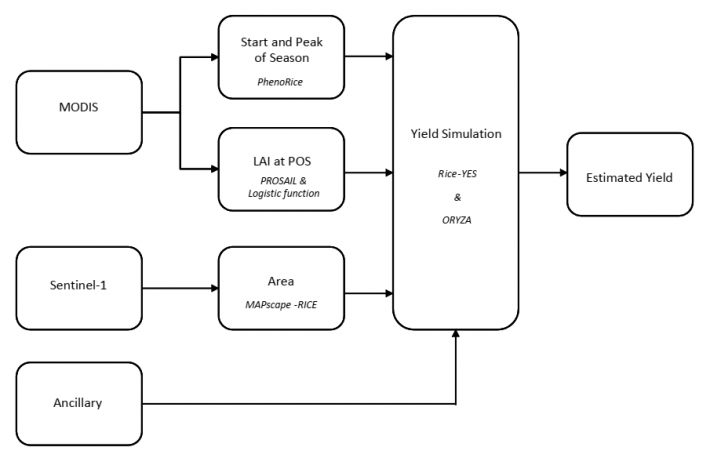
Figure 6: Schematic diagram of the components involved in the generation of spatially explicit rice yield using remote sensing (optical and SAR) and a crop growth model within RIICE project (T. Setiyono et al, 2018).
Results from this study indicate that the approach of assimilating MODIS and SAR data into a crop growth model can generate well-adjusted yield estimates that adequately describe spatial yield distribution in the Red River Delta of Vietnam while reliably replicating official yield data with root mean square error, RMSE, of 0.30 and 0.46 t ha−1 (normalized root mean square error, NRMSE of 5% and 8% - Figure 6) for the 2016 spring and summer seasons, respectively in project area as evaluated at district level aggregation. The rice area map derived from Sentinel SAR data in this study has also a high accuracy of 90.7% and 94.7% for the 2016 spring and summer season, respectively. The Kappa Index values which is greater than 0.80 indicate a strong agreement between the SAR-derived rice area and the land survey information from the ground observation. The information from remote-sensing technology was also useful for identifying geographic locations with peculiarity in the timing of rice establishment, leaf growth, and yield level, and thus contributing to the spatial targeting of further investigation and interventions needed to reduce yield gaps (T. Setiyono et al, 2018).
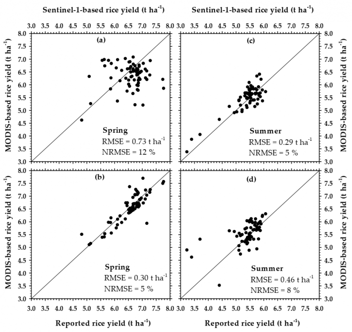
Figure 7: Scatter plot comparing rice yield aggregated at the district level as derived from: MODIS vs. Sentinel-1 (a,c); and MODIS vs. official source (reported) (b,d), for the 2016: spring (a,b); and summer (c,d) seasons in the Red River Delta of Vietnam. n = 66 districts.
In general, although the acceptance and growth of precision agriculture has been rapid, some fundamental requirements are needed to help fully develop and implement this technology. Also, access to timely, cost-effective remote sensing data, or derived value-added products and the development of decision support systems or other expert systems integrating GIS, GPS, and RS technologies in a user-friendly fashion are needed. A subsequent training and technology transfer program to accelerate the acceptance and implementation of this technology for the agri-business sector is also a necessity.
CONCLUSION
One current priority of Vietnamese agriculture sector is to restructure the rice sector and to increase the quality and sustainability of rice production in the Mekong and Red River Deltas. This can be achieved by introducing smart and cost-effective technologies to increase farmers’ incomes and their ability to cope with various environmental threats. Precision farming (technology and decision support systems) application can be one way to improve small-farm management and promote the development of rural areas in Vietnam.
REFERENCES
Kuenzer, C.; Knauer, K. Remote sensing of rice crop areas. Int. J. Remote Sens. 2013, 34, 2101–2139.
General Statistics Office of Vietnam. Statistical Yearbook of Vietnam. Available online: http://www.gso.gov.vn/ (accessed on 15 July 2018).
General Statistics Office of Vietnam (GSO). Statistical Yearbook of Viet Nam 2016; General Statistics Office of Vietnam (GSO): Hanoi, Vietnam, 20163.
Ricepedia. The Online Authority on Rice: Rice Species. Available online: http://ricepedia.org/ (accessed on 15 July 2019).
Kontgis C. A., Schneider, and M. Ozdogan, “Remote Sensing of Environment Mapping rice paddy extent and intensi fi cation in the Vietnamese Mekong River Delta with dense time stacks of Landsat data,” Remote Sens. Environ., vol. 169, pp. 255–269, 2015.
Chen C. F., N. T. Son, C. R. Chen, L. Y. Chang, and S. H. Chiang, “Rice crop mapping using Sentinel-1A phenological metrics,” Int. Arch. Photogramm. Remote Sens. Spat. Inf. Sci. - ISPRS Arch., vol. 41, no. July, pp. 863–865, 2016.
Karila K., O. Nevalainen, A. Krooks, M. Karjalainen, and S. Kaasalainen, “Monitoring changes in rice cultivated area from SAR and optical satellite images in ben tre and tra vinh provinces in Mekong Delta, Vietnam,” Remote Sens., vol. 6, no. 5, pp. 4090–4108, 2014.
Lam Dao Nguyen, Thuy Le-Toan, Hoang Phi Phung, Dang Diem Huong, Nguyen Van Anh Vu, Pham Duy Tien, Nguyen Duy Khang, Do Thanh Long (2018). Rice crop monitoring in Vietnam using radar remote sensing data. Presentation at Earth Observation Technologies for Crop Monitoring: A Workshop to Promote Collaborations among GEOGLAM/JECAM/Asia-RiCE 2018, 17-20 September 2018 – Taichung, Taiwan.
Nguyễn Đăng Vỹ, “Kết quả nghiên cứu ứng dụng công nghệ GIS và công nghệ viễn thám vào quản lý sản xuất lúa vùng đồng bằng sông Cửu Long,” Tạp chí Khoa học và Công nghệ Thủy lợi, vol. 20, 2014.
Setiyono T., E. Quicho, L. Gatti, M. Campos-Taberner, L. Busetto, F. Collivignarelli, F.J. García-Haro, M. Boschetti, N. Islam Khan, F. Holecz, Spatial rice yield estimation based on MODIS and Sentinel-1 SAR data and ORYZA crop growth model, Remote Sensing, 10, 2018. https://www.mdpi.com/2072-4292/10/2/293
http://www.geoglam.org/index.php/en/global-regional-systems-en/asiarice
http://asia-rice.org/files/taiwan-2018/20180917/Rice_LDNguyen_1809.pdf
https://g4aw.spaceoffice.nl/en/projects/g4aw-projects/77/satellite-data-...
http://www.p-gis.com/2018/07/du-theo-doi-lua-vung-ong-bang-song-hong.html
|
Date submitted: August 5~9, 2019
Reviewed, edited and uploaded: August 15, 2019
|

A Review of Precision Agriculture in Rice Production in Vietnam
ABSTRACT
Precision Agriculture (PA) is a key component of the agricultural digitization and means to apply the exact and correct amount of inputs like water, fertilizers, pesticides etc. at the correct time to the crop for increasing its productivity and maximizing its yields. It provides farmers with information to build up a record of their farms, helps to make decisions, promotes traceability and provides better marketing of farm products. Finally, it enhances the quality of the product itself. Rice production plays an important role in food security, rural employment, and foreign exchange in Vietnam as rice contributes to around 50% of the gross production of food crops. However, the technology development in the rice production in Vietnam is still in its infancy stage. The digitalization has not reached Vietnam’s rice sector yet. Most of Vietnamese rice farmers still use their own experiences as well as recommendations from research and extension services to undertake activities in seed selection, land preparation, crop management, irrigation and harvest. They are also still using basic computers, standard internet information and basic information and communications technology in general. The recently integrated rice crop management systems or precision rice-farming system, which starts to be adapted to the social and economic conditions in Vietnam, are promising for effective input use, increased productivity and improved farm profits. A growing number of farmers are starting to adopt information technology/digital technology and data-driven innovations. The paper will highlight some results of agriculture precision application in rice production in Vietnam.
Keywords: precision agriculture, rice production, information technology, crop manager, Vietnam
INTRODUCTION
Rice production has played an important role in food security, rural employment, and foreign exchange in Vietnam. Rice is the most important food crop in Vietnam and accounts for around 50% of gross production of other food crops (GSO, 2018). Although the planted rice area harvested just expanded from 6.8 million ha in 1995 to 7.5 million ha in 2015 (GSO, 2018), the use of input-responsive modern varieties, sufficient fertilizers, and an increase in the proportion of irrigated rice areas (93.4%) account for the high yields in recent decade. Since then, Vietnam has continuously increased rice production to become the second largest rice exporter worldwide in 2012 (GSO, 2018). The Mekong Delta alone, which is often called “Vietnam’s Rice Bowl” contains the majority of the area designated for rice agriculture, yields 54% of the national rice production and contributes to the 95% of rice exports in Vietnam, which accounts for 4.7 million tons of rice every year (IRRI- Ricepedia, 2018). It not only feeds a population of 95 million (GSO, 2018) but also provides food security in Southeast Asia. According to the topography, soil, and climate conditions, agricultural activity can be divided into eight agricultural ecological sections but much of the rice cultivation is concentrated in two river deltas: the Mekong (over half of the country’s rice area) and Red River Delta.
Like in many developing countries, there is no specific precision agriculture/farming system programme – there is a shortage of capital, knowledge and technologies. Nevertheless, improved agricultural management is practiced in Vietnam, exploiting available means and resources to increase agricultural productivity and production. In rice production systems, farmers in Vietnam use their own experiences as well as recommendations from research and extension services to undertake activities in seed selection, land preparation, crop management, irrigation and harvest. The recently developed integrated rice crop management systems or precision farming system (Global Positioning System, Remote Sensing Technologies,, Variable-Rate Technologies, Grain Yield Monitors for Mapping etc…) , which start to be adapted to the social and economic conditions in Vietnam, are promising for effective input use, increased productivity and improved farm profits.
THE RICE CROP MANAGER (RCM): ICT-APPLICATION FOR SMART-RICE PRODUCTION IN VIETNAM
The improvement of crop management practices among small rice farmers in developing countries with small farm size, including Vietnam, is often not an easy task. Crop management practices must be adjusted to crop varieties, environmental factors, knowledge and market forces. Input and output prices affect farmers’ decisions with regard to the level of inputs to be applied, while employment opportunities influence the time spent by farmers in crop management. The improvement of farmers’ management skills through the accumulation of data and information is an important aspect of precision farming system and it has been integrated into the development and dissemination of rice crop management (RCM) in a number of rice-producing countries like Vietnam. Site-specific rice crop management allows inputs to be reduced, while optimizing outputs, both of which are attractive to the farm producers. At the same time, by reducing inputs, the run-off of fertilizers and pesticides is reduced, thus improving the environmental condition of the agro-ecosystem .
Rice Crop Manager (RCM), a web-based application available on smart phones have been developed by IRRI, is specifically designed for rice farmers to guide them in nutrient management as well as other cultural management practices. The RCM enables agricultural extension staff to ensure sustainable productivity gains for poor rice farmers through cost-effective crop management practices. Information and Communication Technologies (ICTs) plays an increasingly important role in making agricultural advisory scalable and accessible to large numbers of farmers, while providing timely and farm-specific information to support farmers’ farmland crop management decisions. The use of the app is free. This cost-saving application is a step towards precision farming. Farmers will be informed as to what specific fertilizer to use, when to use it and at how much quantity. They are also given guides as to seeding rate, water and weed management. The RCM uses results of research and existing knowledge to provide farmers with ‘precise’ field- and farmer-specific recommendations and uses advances in ICTs to provide professional extension and advisory services.
Figure 1: Vietnamese Version of The Rice Crop Manager
RCM tested regionally at the Mekong River Delta and Red River Delta of Vietnam through an collaborative project between IRRI and Cuu Long Rice Research Institute and Soils and Fertilizers Research Institute (2 member institutions under Vietnam Academy of Agricultural Sciences (VAAS)).IRRI and VAAS are also partnering to develop a project with national support for the development testing, endorsement, release, and dissemination of Rice Crop Manager in the Mekong Delta and Red River Delta. This project aims to (1) develop beta versions of Rice Crop Manager mobile apps customized for the cropping systems of the Mekong Delta and Red River Delta, 2 major rice-growing areas of Vietnam programmed in HTML5 and accessible athttp://webapps.irri.org/vn/rcm; and (2) incorporate new modules on adjusted rice management practices into a new decision tool called CIRCLE (Climate-Informed Rice Crop and Low Emission), supplementing the output of Rice Crop Manager with preliminary estimates of greenhouse gas emissions.
This project will build on past collaborative IRRI-Vietnam research, which resulted in the initial development of Nutrient Manager for Rice where IRRI has already developed. It started the development of Rice Crop Manager from the preliminary Nutrient Manager for Rice. The beta version of the Rice Crop Manager (RCM) mobile application customized for the cropping systems of the Mekong Delta and Red River Delta was developed. It is accessible at http://webapps.irri.org/vn/rcm. It underwent pre-testing in February 2015 in Bac Lieu Province.
A beta version of CIRCLE Manager, using IPCC published guidelines for estimating methane and nitrous oxide emissions, was integrated into the RCM for the Mekong Delta. Information obtained from the CLUES project and the climate-smart village (CSV) in Bac Lieu was used to fine-tune the RCM and CIRCLE Manager for the Mekong Delta. Partnerships were initiated to enable testing at the CSV in Bac Lieu starting in February 2015. Another blueprint, which is feasible with the current configuration of RCM but not yet implemented, is to enable the use of CIRCLE Manager at the end of the cropping season to calculate the estimated greenhouse gas emissions for the water and crop management practices actually used by the farmer.
Late in 2014, the pre-scaling and testing process of the RCM has started for both the Mekong River and Red River deltas in the Northern and Southern parts of Vietnam. To date, two beta versions in Vietnamese have been completed for the RCM basic features and are now being tested through Randomized Controlled Trials (RCTs) by 96 farmers, of which 30 are women, under the guidance of the provincial Department of Agriculture and Rural Development (DARD). Data on optimal input use and maximization of yields is collected and compared with farmers’ current practices (control group). 12 farmers and 4 women farmers are testing the RCM in an LSRF in the Province of Bac Lieu in collaboration with Better-Rice-Initiative-Asia (BRIA). There will be 3 replications of the RCTs over 3 rice cropping season. The results from field testing in Mekong River and Red River deltas shown that farmers increased net income in 4 out of 5 seasons by switching to the recommended practices of RCM
Figure 2: Added net benefit from field-pilot RCM application in Vietnam
Field research has shown yields targeted by RCM were achieved or exceeded in winter-spring. It appears that RCM set N fertilizer rates too low for the target yield in winter-spring. Improvement in setting of location- and season-specific yield targets is still feasible.
Figure 3: Rice grain yield comparison at field-pilot RCM application in Vietnam
After 2 years of piloting in Dong Thap, Hau Giang and Long An, RCM app proved suitable for Mekong Delta farmers. According to IRRI experts and the users themselves, RCM has "fairly" advised farmers about the diet for rice as well as the way to take care of rice in accordance with weather conditions and the pest management. If in the past, most farmers cultivated rice based on subjective experience, after using RCM, the application helped them improve cultivation efficiency, save fertilizer and nutrients for rice but still achieving good productivity. RCM can be adopted in other localities, especially the provinces with a large area of rice cultivation such as An Giang to improve production efficiency, reduce costs and increase income for farmers, to help farmers become gradually familiar with smart production management ...
The RCM in Vietnam also includes new features on Climate Smart Agriculture (CSA). These will gradually move the RCM from its basic crop management functions, such as forecasted yields based on appropriate fertilizer use, to a broader advisory service platform. The existing greenhouse gases (GHG) calculator for a targeted rice field will, in the next future, will be able to calculate emission reductions when technologies such as Alternate Wetting and Drying (AWD) or different straw management practices are adopted by farmers. Before the end of the year, a CSA agro-advisory service will start delivering SMS on short range and extended weather forecasts and related agromet advice to rice growers’ mobile phones. This system helps farmers to know which yields are tobe expected in a specific climate context at different rice growth stages.
The RCM also has attracted huge interest from government and private partners, who play important role for its out-and up-scaling such as MARD, NAEC, PetroVietnam Fertilizer and Chemicals Corporation (PVFCCo). IRRI obtained support from PVFCCo for field research in the Mekong Delta for 2015 to evaluate and refine the fertilizer recommendation in RCM and to promote RCM. RCM was additionally enhanced to enable the setting of climate-adjusted yields based on Oryza crop simulations using historical climate data and seasonal climate forecasts. The testing, verifying, promoting, and disseminating of the updated beta version of RCM and CIRCLE Manager have been delayed to 2015.
An additional support tool, targeted to be introduced by the end of 2015, is the ‘Seed Selector’ that helps farmers to choose the most suitable seed varieties considering production objectives, field conditions and investment potential. The software automatically selects three best seed variety options and their sources. The most recent development planned is an application that supports affected rice growers dealing with salinity intrusion in rice fields in the coastal provinces of the Mekong river delta. Affected farmers are selected from areas that are known from the GIZ
Integrated Coastal Management Program (ICMP) in the salinity belt of the Bac Lieu and Hau Giang provinces. SALTS (Salinity Advisory as a Location specific Timely Service) advisory will be integrated into the RCM platform and complement the current ICMP activities for the dissemination of salt-tolerant rice varieties. ICMP is expected to play a pivotal role in knowledge sharing at national level and among provincial partners about these new RCM advisory services.
OPERATIONAL SPATIAL DATA-BASED RICE MONITORING SYSTEM IN VIETNAM
The precision farming system employs the innovations and new technologies including Geographic Information Systems (GIS), Global Positioning Systems (GPS) and Remote Sensing (RS) technologies to allow farm producers to manage within field variability to maximize the cost-benefit ratio, rather than using the traditional whole-field approach. Variable Rate Technology (VRT) available with farm implements, such as fertilizer or pesticide applicators and yield monitors, has evolved rapidly and has fostered the growth of precision agriculture. Remote Sensing (RS) provides input data for many precision agriculture applications including pre-growth soil fertility and moisture analyses, crop growth and growth detract ant monitoring (crop scouting), and yield forecasting. Remote sensing data might provide quick high-quality, consistent, and timely information about spatial and temporal changes in the rice cropping area in different seasons on regional and global scales
In Vietnam, rice monitoring using remote sensing has received great attention from managers and researchers. The remote sensing of rice-growing areas can not only contribute to the precise mapping of rice areas and the assessment of the dynamics in rice-growing regions, but can also contribute to harvest prediction modelling, the analyses of plant diseases, the assessment of rice-based greenhouse gas (methane) emission due to vegetation submersion, the investigation of erosion-control-adapted agricultural systems, and the assessment of ecosystem services in rice-growing areas. Effective rice monitoring is essential for supporting policy making with accurate information concerning rice-growing areas, estimation of production, and seasonal cropping patterns to achieve increased economic development and food security. Therefore, a number of rice monitoring projects have been implemented in Vietnam.
There are so many studies of rice crop monitoring using remote sensing data has been implemented in the Mekong Delta. Recently in 2015, Caitlin Kontgis et al (2015) used Landsat-5/7/8 image data to map rice paddy extent and intensification in the Mekong River Delta. The results show that this method can map rice paddies with over 90% overall accuracy (and errors of omission and commission ranging from 6 to 25%) at a finer spatial resolution than previous efforts. C.F. Chen et al (2016) used using Sentinel-1A phenological metrics to build rice maps in the Mekong Delta region with an accuracy of 86.2% . In addition, Kirsi Karila et al (2014) combined data of ENVISAT radar, Landsat and SPOT optical images to separate rice planting area from aquaculture and fruit trees planting area with an overall accuracy of 80%. Besides, Nguyen Dang Vy (2014) also used MODIS image with an 8-day regular repeat cycle to apply for the management of rice production in the Mekong Delta. It provides the capability to centrally, reveals on its map details of each ward, each farm and each paddy field according to demand of each local area. Together yet independent from data received by each local place is the picture data produced by MODIS satellite, with new method of rice recognition and updates regularly, allows rice sowing process monitoring of each paddy field, determines rice stages on ricefields, report on rice health and predicts rice productivity [22]. Similar to studies in other regions of the world, the method used in Vietnam also focuses on studying the growth characteristics of rice so as to determine the appropriate thresholds for specific indicators (NDVI/EVI) to separate rice from other types of plantation.
The rice monitoring project of the Ministry of Agriculture and Rural Development in 1999 was one of the pioneering steps in using satellite images to monitor the crop production. The project marks a significant milestone for the cooperation between Vietnam's northern and southern research institutes as well as direct connection to provincial agencies in the Mekong Delta. The group provided the Ministry of Agriculture with 20 RADARSAT-1 satellite images that collected in the Mekong Delta in the summer rice cropping season1999/2000.
From 2013-2015, Vietnam joins Asia Rice Crop Estimation and Monitoring (Asia-RiCE) initiative that aims at improving operational rice crop monitoring and estimation using Earth observations in the Asian region. The Asia-RiCE initiative (http://www.asia-rice.org) has been organized to enhance rice production estimates through the use of Earth observation, and seeks to ensure that Asian rice crops are appropriately represented within GEOGLAM. his work was conducted over Asian 100x100km Technical Demonstration Sites (TDS) with satellite –based cultivated area and growing stage maps generated. Asia-RiCE is composed of national teams that are actively contributing to the Crop Monitor for AMIS. These teams are working to develop technical demonstrations of rice crop monitoring activities using both Synthetic Aperture Radar (SAR) data and optical imagery (such as from MODIS, SPOT-5, Landsat, and Sentinel-2). The Asia-RiCE teams are also developing satellite-based agro-met information for rice crop outlook, crop calendars and damage assessment in cooperation with ASEAN Food Security Information System (AFSIS) for selected countries (currently Indonesia, Thailand, Vietnam and Japan. Asia-RiCE team members studied the TDS to estimate rice planted area, growing status, and damage area using time series SAR data from multiple providers in Indonesia, Vietnam, Thailand, Japan and others. The CESBIO team worked to define standard ground observation data collection method and developed rice monitoring methods using Sentinel-1 time series, under the GEORICE project funded by ESA, in cooperation with VAST, Vietnam (GEOLAM, 2018)
Figure 4: Schematic diagram of the rice monitoring method under Asia-RiCE project (Lam Dao Nguyen et al, 2018)
Following up Asia-RiCE, Vietnam’s implementing a new research project on applied research on the multi-temporal, multi-resolution optical and radar remote sensing data for rice planted area monitoring and rice yield, production estimation in the Mekong Delta and Red River Delta (VNRice project, 2017-2020). The project aims to evaluate the use of remote sensing data in rice monitoring and yield estimation, towards an operational system for rice crop inventory in Vietnam. The expected outputs are rice crop area maps, yield & production estimation, rice cropping calendars and crop growth status.
Recently, the Vietnam-Netherlands collaborative project (Sat4Rice) have been implementing in the Mekong River Delta, one of the largest rice producing regions in the world, fulfilling an important role in global food security. Sat4Rice (satellite data for rice producers) aims to improve rice production in the whole Mekong Delta, by providing satellite data driven information services. These information services increase the effectiveness of existing extension services to smallholder rice farmers. Loc Troi Group’s (LTG) extension workers, the ‘Farmers Friends’, are provided with near real-time data on production, inputs and environmental factors. Satellite data and field observations are integrated in a geodata platform, that is accessible through a browser-based smart phone app (progressive web app). This raises awareness, builds resilience of local communities and improves the efficiency of inputs for rice production in the Mekong delta such as water, fertilizers and pesticides. The project aims to reach a minimum of 300,000 smallholder rice farmers in the Mekong Delta, particularly in the An Giang and Soc Trang provinces. After the project, the service will be scaled-up further, to reach millions of rice farmers in the Mekong Delta and beyond. Sat4Rice achieves a strong business proposition by adding value on multiple places in the value chain. Farmers’ income increases due to improved rice farming conditions, whereas rice processors (like LTG) benefit from more efficient logistics and use of resources. Partners in the value chain profit from the extensive and detailed agricultural database of Sat4Rice. Key indicators are calculated every day, using latest satellite images and field observations. This provides the information services (Field characteristics and administrative data; Rice growth monitoring, forecast and use of inputs; Pest and diseases observations and risks; Flood monitoring and field preparation) to all value chain partners. After the project, the Sat4Rice information services are provided by Loc Troi Group, with technical support from the consortium partners. Additionally, Sat4Rice is exploring further collaboration with value chain partners in sustainable rice production to strengthen its impact on the sector and extend its reach, potentially to other commodities such as coffee (G4AW, 2018).
In the North of Vietnam, the project "Monitoring rice production in the Red River Delta using remote sensing data" was carried out by the Center for Remote Sensing and GIS, the National Institute of Agriculture Planning and Projection. With the use of MODIS satellite images, rice production in the Red River Delta has been updated regularly. Planting areas as well as rice harvesting time are analyzed from satellite images, allowing managers to continuously monitor production in the area. The model of rice yield is based on linear regression data reported by the local departments from 2007 to present, combining the vegetation index, environmental index, water surface, heat ... allows early forecast of yield and yield of each crop, time 1 month before harvest. However, the project has ended and has stopped providing new, updated rice maps for the Red River Delta in recent years.
Figure 5: The website of monitoring rice production in the Red River Delta using remote sensing data
The website of the project is located at http://www.theodoilua.com (Figure…). The main products of the project are published in including:
In 2018, within the project “the Remote Sensing-based Information and Insurance for Crops in Emerging Economies - (RIICE)”, International Rice Research Institute demonstrated a synergetic method of exploiting optical and SAR remote-sensing data in the context of assimilation of critical information (such as rice area, start of season and LAI for rice yield simulation) and crop growth model-based rice yield estimation with the intention of historical yield data generation for the Red River Delta of Vietnam. The developed system combines MODIS and SAR-based remote-sensing data to generate spatially explicit inputs for rice using a crop growth model. MODIS reflectance data were used to generate multi-temporal LAI maps using the inverted Radiative Transfer Model (RTM). SAR data were used to generate rice area maps using MAP Scape-RICE to mask LAI map products for further processing, including smoothing with logistic function and running yield simulation using the ORYZA crop growth model facilitated by the Rice Yield Estimation System (Rice-YES).
Figure 6: Schematic diagram of the components involved in the generation of spatially explicit rice yield using remote sensing (optical and SAR) and a crop growth model within RIICE project (T. Setiyono et al, 2018).
Results from this study indicate that the approach of assimilating MODIS and SAR data into a crop growth model can generate well-adjusted yield estimates that adequately describe spatial yield distribution in the Red River Delta of Vietnam while reliably replicating official yield data with root mean square error, RMSE, of 0.30 and 0.46 t ha−1 (normalized root mean square error, NRMSE of 5% and 8% - Figure 6) for the 2016 spring and summer seasons, respectively in project area as evaluated at district level aggregation. The rice area map derived from Sentinel SAR data in this study has also a high accuracy of 90.7% and 94.7% for the 2016 spring and summer season, respectively. The Kappa Index values which is greater than 0.80 indicate a strong agreement between the SAR-derived rice area and the land survey information from the ground observation. The information from remote-sensing technology was also useful for identifying geographic locations with peculiarity in the timing of rice establishment, leaf growth, and yield level, and thus contributing to the spatial targeting of further investigation and interventions needed to reduce yield gaps (T. Setiyono et al, 2018).
Figure 7: Scatter plot comparing rice yield aggregated at the district level as derived from: MODIS vs. Sentinel-1 (a,c); and MODIS vs. official source (reported) (b,d), for the 2016: spring (a,b); and summer (c,d) seasons in the Red River Delta of Vietnam. n = 66 districts.
In general, although the acceptance and growth of precision agriculture has been rapid, some fundamental requirements are needed to help fully develop and implement this technology. Also, access to timely, cost-effective remote sensing data, or derived value-added products and the development of decision support systems or other expert systems integrating GIS, GPS, and RS technologies in a user-friendly fashion are needed. A subsequent training and technology transfer program to accelerate the acceptance and implementation of this technology for the agri-business sector is also a necessity.
CONCLUSION
One current priority of Vietnamese agriculture sector is to restructure the rice sector and to increase the quality and sustainability of rice production in the Mekong and Red River Deltas. This can be achieved by introducing smart and cost-effective technologies to increase farmers’ incomes and their ability to cope with various environmental threats. Precision farming (technology and decision support systems) application can be one way to improve small-farm management and promote the development of rural areas in Vietnam.
REFERENCES
Kuenzer, C.; Knauer, K. Remote sensing of rice crop areas. Int. J. Remote Sens. 2013, 34, 2101–2139.
General Statistics Office of Vietnam. Statistical Yearbook of Vietnam. Available online: http://www.gso.gov.vn/ (accessed on 15 July 2018).
General Statistics Office of Vietnam (GSO). Statistical Yearbook of Viet Nam 2016; General Statistics Office of Vietnam (GSO): Hanoi, Vietnam, 20163.
Ricepedia. The Online Authority on Rice: Rice Species. Available online: http://ricepedia.org/ (accessed on 15 July 2019).
Kontgis C. A., Schneider, and M. Ozdogan, “Remote Sensing of Environment Mapping rice paddy extent and intensi fi cation in the Vietnamese Mekong River Delta with dense time stacks of Landsat data,” Remote Sens. Environ., vol. 169, pp. 255–269, 2015.
Chen C. F., N. T. Son, C. R. Chen, L. Y. Chang, and S. H. Chiang, “Rice crop mapping using Sentinel-1A phenological metrics,” Int. Arch. Photogramm. Remote Sens. Spat. Inf. Sci. - ISPRS Arch., vol. 41, no. July, pp. 863–865, 2016.
Karila K., O. Nevalainen, A. Krooks, M. Karjalainen, and S. Kaasalainen, “Monitoring changes in rice cultivated area from SAR and optical satellite images in ben tre and tra vinh provinces in Mekong Delta, Vietnam,” Remote Sens., vol. 6, no. 5, pp. 4090–4108, 2014.
Lam Dao Nguyen, Thuy Le-Toan, Hoang Phi Phung, Dang Diem Huong, Nguyen Van Anh Vu, Pham Duy Tien, Nguyen Duy Khang, Do Thanh Long (2018). Rice crop monitoring in Vietnam using radar remote sensing data. Presentation at Earth Observation Technologies for Crop Monitoring: A Workshop to Promote Collaborations among GEOGLAM/JECAM/Asia-RiCE 2018, 17-20 September 2018 – Taichung, Taiwan.
Nguyễn Đăng Vỹ, “Kết quả nghiên cứu ứng dụng công nghệ GIS và công nghệ viễn thám vào quản lý sản xuất lúa vùng đồng bằng sông Cửu Long,” Tạp chí Khoa học và Công nghệ Thủy lợi, vol. 20, 2014.
Setiyono T., E. Quicho, L. Gatti, M. Campos-Taberner, L. Busetto, F. Collivignarelli, F.J. García-Haro, M. Boschetti, N. Islam Khan, F. Holecz, Spatial rice yield estimation based on MODIS and Sentinel-1 SAR data and ORYZA crop growth model, Remote Sensing, 10, 2018. https://www.mdpi.com/2072-4292/10/2/293
http://www.geoglam.org/index.php/en/global-regional-systems-en/asiarice
http://asia-rice.org/files/taiwan-2018/20180917/Rice_LDNguyen_1809.pdf
https://g4aw.spaceoffice.nl/en/projects/g4aw-projects/77/satellite-data-...
http://www.p-gis.com/2018/07/du-theo-doi-lua-vung-ong-bang-song-hong.html
Date submitted: August 5~9, 2019
Reviewed, edited and uploaded: August 15, 2019