ABSTRACT
A SMART platform is a farming management system that monitors the variations of crop, environment and farmer practices in each farm upon a combination of satellite or drone images, sensor technologies, mobile applications, positioning technology, and the Internet of Things. The SMART platform stands for S (Satellite or drone images data for plant health), M (Meteorological data for crop environment data), A (Application data for farmer practices data), R (Robotics or machineries for precise implementing practices) and T (Terminal for data visualization and analytics). This platform has been deployed since 2017 for the target area of Thung Rangsit of the central part of Thailand. The area covers the boundaries of 5 provinces, Pathum Thani, Phranakhon Si Ayutthaya, Sara Buri, Nakhon Nayok and Chachoengsao with an area of approximately 208,000 hectares. In first phase of this platform, all the collected data were visualized in dashboard so that it can display planting area, plant species, varieties, planting time and harvest time etc. This information can be used for planning of management both in the individual farm and the whole area. The data will be collected continuously to create a big data for analysis, predictions or modelling various occurrences. In this platform new technologies or innovations are transferred to farmers by making demonstration plots in which farmers participate. These technologies include rice planting by drilling machine, using of fertilizers according to soil analysis and pesticide spraying using drones or spraying machine etc. Finally, we believe that this platform can be adopted and used by the government.
Keywords: Communication technology, Economics, Precision agriculture, Rice, Oil palm, Sustainability
INTRODUCTION
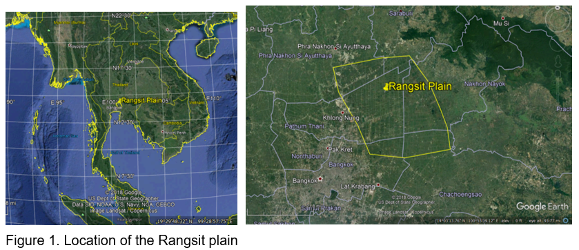
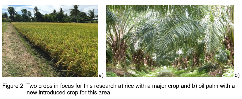
The Rangsit Plain or “Thung Rangsit” is the developed agricultural area for rice growing to support domestic and export demands since 1890s. In this area the Rangsit canal is the first irrigation project of Siam (Thailand) initiated by King Rama V at that time. According to well-developed irrigation system for agriculture, this area is ideal for rice growing together with other agricultural practices. The major crop in this area is rice with most of the farmers still growing crops by conventional practices without the integration of new technologies for efficiency enhancement. Some farmers have heard about new technologies, but they don’t know how to put it into practice. Therefore, if the knowledge can be transferred to farmers properly, rice cultivation can be improved immensely. Other than rice, there are new crops which have been recently introduced to this area, such as oil palm, which is also gaining more economic value here. However, farmers grow oil palm through conventional practices. Thus, if the good agricultural practice can be transferred to farmers in this area, oil palm cultivation practices will be increased efficiently. Especially, in the current situation when this area soon to be changed into another urban area, this profound land will be utilized for other purposes. Therefore, the study of agriculture in this area is very useful for government or other sectors to use this information for decision making of land use in the future.
The Rungsit plain consists of 5 provinces namely Pathum Thani, Phranakhon Si Ayutthaya, Saraburi, Nakhon Nayok and Chachoengsao with covering an area of 1.9 million rai, most of which are agricultural lands, accounting for 69.39% (208,000 ha) of the total area. The rice area is 74.31% (157,000 ha) and the oil palm plantation area is 1,700 ha (Figure 1 and Figure 2).
The operations of the project were as follows: a survey of the situation of economic crops in the area, including species, varieties, extend, income and farmer practices. The details of activities can be summarized into six parts: 1) the economic situation in Thung Rangsit; 2) the transfer of management technology; 3) the development of a database of plant varieties grown in the area for use in the program forecasting environment suitable for plant species, field, as well as management and 4) system development / process of advising plant production of experts through the digital media.
SMART PLATFORM
Precision agriculture (PA) or precision farming is a modern farming management concept using digital techniques to monitor and optimize agricultural production processes. Rather than applying the same amount of management or agricultural chemicals over an entire agricultural field, PA will measure variations in conditions within a field and adapt its management strategies accordingly. PA methods promise to increase the quantity and quality of agricultural output while using less input (water, energy, fertilizers, pesticides, etc.). The potentials of precision agriculture for economic and environmental benefits could be visualized through reduced use of water, fertilizers, herbicides and pesticides besides the farm equipment (Banu, 2015).
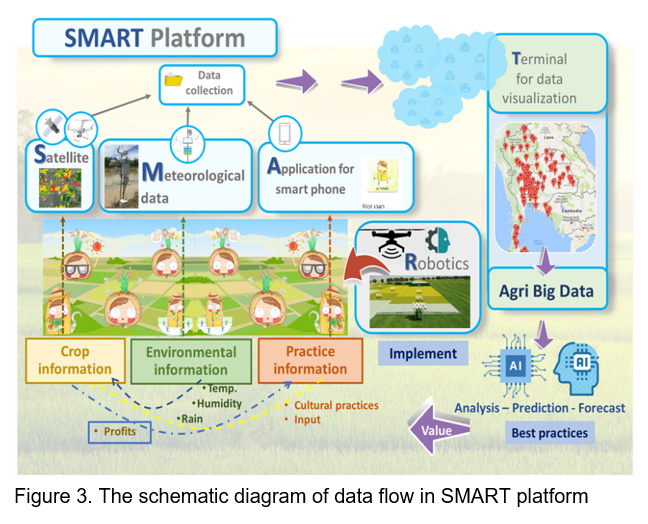
SMART platform is a big data management system for planning and organizing agriculture both individually and in the whole system. All the information was analyzed to report, predict, forecast or model the changes in the field by Agri Big Data system. Implementing practices were specified to the area by GPS guidance with variable rate technologies. This platform has developed as a data bank system for storing data from all 3 parts such as orthophoto taken from satellites or drones, meteorological data from weather station and farmers' practices with smart phone applications. The data were analyzed and used for managing the field (Figure 3). The detail of each module is shown below.
S: Satellite or drone data
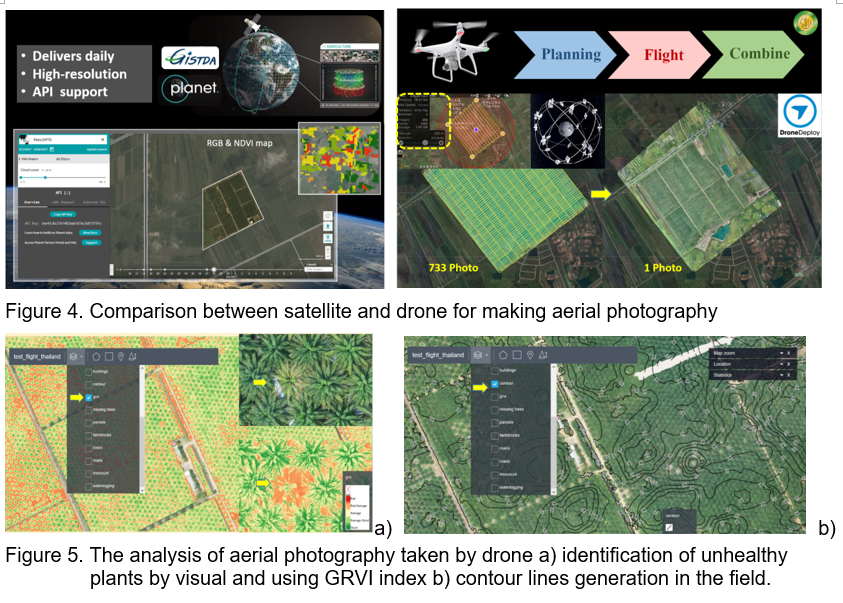
The geo-information plays an important role to support agriculture. In general, these applications or orders are fulfilled by spaceborne satellite imaging remote sensing technology. There are only limited requests for doing the aerial photography. Furthermore, in some application such as monitoring of the individual plant structure, the high-resolution satellite imagery still cannot fulfill this. One of the advantages of the aerial photograph taken by unman aerial vehicle (UAV) in comparison with satellite imagery is that it can be used to observe each individual plant structure.
Because of the availability of aerial photography by spaceborne satellite than the aerial photograph maps from unman aerial vehicle (UAV), it was used for tracking changes in the fields such as plant health, disease or insect infestation, yield forecasting etc. The aerial photography taken by commercial drone can be utilized for making the high-resolution map with the help of the commercial software. It can easily detect unhealthy oil palm tree, or it can be used for growth index of GRVI (green red vegetation index) to detect unhealthy tree (Motohka et al. 2010). Moreover, the information of contour lines can directly be used in irrigation system designing both before and after planting (Figure 5) (DroneDeploy, https://www. dronedeploy. com and EagleSensing, https://www. eaglesensing. com/).
M: Meteorological data
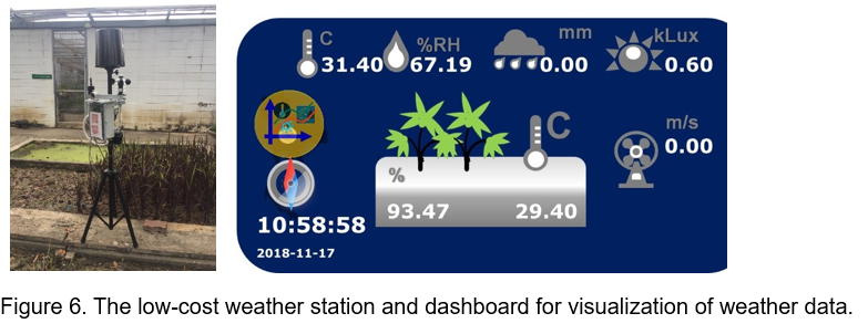
Modern weather stations incorporate numerous sensors; their types vary based on the fields of application. In general, a weather station is usually constituted by rain sensor, to detect rainfall; anemometer, to measure wind speed and direction; air temperature sensor; air humidity sensor; barometer, to monitor atmospheric pressure. In the field of agrometeorology, this basic equipment can be supplemented with sensors for solar radiation, and for the humidity and temperature of the soil. The weather data can be viewed via the web bash board from any computer, and often they also include visual displays for quick reference. In general, 1 weather station for the area of 2 -5 km2 can represent the micro climate of each region.
In addition, low cost and efficient weather stations are always preferred by the farmers. Hence, it is important to study the weather parameters recorded by the stations to understand its limitations, and to improve its efficiency. Only the reliable data are helpful for farmers to make decision, for example, when to start planting, when to harvest, when to water plants and by how much, when each phenology state will occur, etc. (Trogo et al. 2015 and Tenzin et al. 2017). (Figure 6)
A: Application data
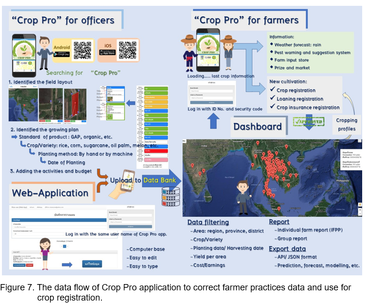
Mobile or Smartphone applications which is called apps could be availed of all such information with the knowledge, farm practice recommendation, pest warning, changing climate, product prize etc. The mobile app is one of the platforms, where farmers can get all solutions and information in just one touch. Smartphone apps revolutionized the connectivity and were used for transferring agri-information to farmers (Barh and Balakrishnan, 2018 and Brugger, 2011). Moreover, it can be used as a tool for correcting farmer practices in each crop.
"Crop Pro" application was developed for correcting data of basic information and farm activities such as name for farmer, ID no., area of planting, location, species, variety, planting date, fertilizer application date, pesticide spraying date, harvesting date, expend, income etc. Farmers or officers can input that information by smart phone application or web application. This information of planting can be shared to other farmers via the QR code with generated by application. Moreover, the information can be shared to the data bank for generation the big data of crops cultivation.
T: Terminal for data visualizations
A huge amount of data is generated from many devices (e.g., sensors, robotic drones, etc.) and services (e.g., weather service, market price service, etc.). Leveraging these multiple forms of data might provide many benefits to farmers, private companies and government officers. However, these massive data are often complex and heterogeneity (e.g., structured, semi-structured, and unstructured), so it is very difficult to comprehend them. Due to these factors, big data analytics and visualization techniques play an important role in human understanding (Gandomi and Haider, 2015 and Harshitha et al., 2017).
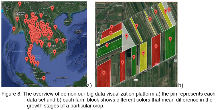
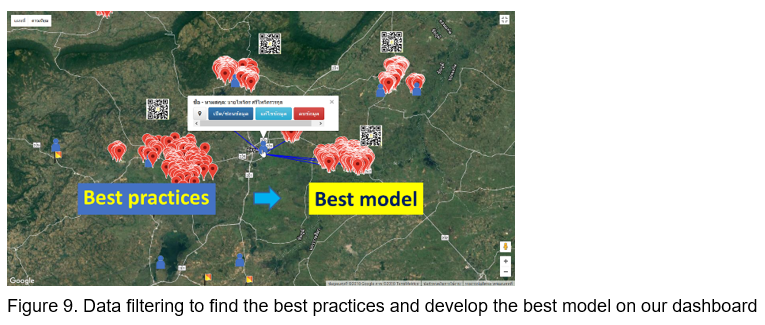
An overview of the architecture of our big data visualization platform is illustrated in Figure 1. The pin represented to each data set. First, users can make a request to see data visualization on the web interface by then they can fill out the favorite criteria such as province, plant species, variety, date of planting etc. Second, each data set can create an individual farm report to show the profile of production, cost partitioning in each activity, profit, etc. Finally, all data can be exported for future data analytic protocol (Figure 8). The easy method of data visualization is filtering the data to find the best practices in the same area of crop production and use it as a protocol to promote to another. All farm practices profile can be analyzed to find the weak point of each group and solve a particular problem.
R: Robotics and machineries
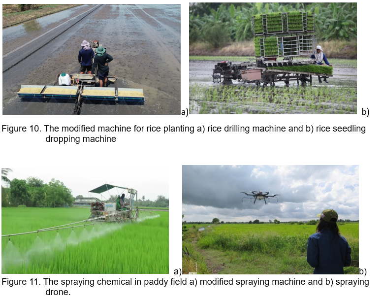
Nowadays, many farmers are responding to the farm labor shortage by turning to modified equipment or machines and some are looking for the automatic advanced technology equipment or machines that perform tasks such as seeding, spraying, weeding and harvesting. There are 3 innovation machines, rice drilling machine, rice seedling dropping machine and modified boom spray machine that we promoted farmer to use for solving the labor shortage (Figure 10 and Figure 11).
The site-specific management (SSM) is the idea of doing the right thing, at the right place, at the right time. Precision agriculture provides a way to automate SSM using information technology. Artificial intelligence, field sensors, and data analytics are some of the advanced systems used in that endeavor, but the one area in which these technologies converge is robotics. Agricultural robots, sometimes known as agribots, are one of the key trends that will deeply influence agriculture. In the target area, the suitable robotic technology is spraying drone that some rice farmer already adopted for their farm. The goals of using robotics are automatics and precision management by using automatic steering machine and variable rate application technology (Bongiovanni and Lowenberg-Deboer, 2004).
CONCLUSION
In first phase of SMART platform, 2017 - 2019, of the training collected data set from selected area such as plant health, plant microclimate and farmer practices can be visualized in dashboard so that it can display farm area, plant heath, temperature, humidity, rainfall, plant species, varieties, planting time and harvest time etc. This information can be used for planning and management both in the individual farm and the whole area. The data will be collected continuously in all target areas to create a big data for analysis, predictions or modeling various occurrences. In this platform, new technologies or innovations are transferred to farmers by making demonstration plots in which farmers participate. These technologies including rice drilling machine, rice seedling dropping machine and pesticide spraying using drones or spraying machine are adopted by some farmers. The goal of precision agriculture research is to define a decision support system (DSS) for the whole farm management with the goal of optimizing returns on inputs while preserving resources. Finally, we believe that this platform can be adopted and used by the government.
ACKNOWLEDGMENTS
The authors would like to thank the team of the project of Development a System for Collecting Crop Cultural Practices Data to Create a Big Data for the Decision of Planting in Thung Rangsit, under the Agriculture Cluster, Research University Network (RUN), for conducting the research projects in Thung Rangsit. Authors also deeply thanks to the research partners such as Ministry of Agriculture and Cooperatives (Rice department, Department of Agriculture and Department of Agriculture and Extension) and Ministry of Science and Technology (Geo-Informatics and Space Technology Development Agency (Public Organization), GISTDA and National Science and Technology Development Agency, NSTDA, for providing data and some analysis, as well as the necessary technical supports. The research was made possible by funding of the National Research Council of Thailand.
REFERENCES
Banu, S. 2015. Precision Agriculture: Tomorrow’s Technology for Today’s Farmer. J Food Process Technol 6 (8): DOI: 10.4172/2157-7110.1000468
Barh, A. and M. Balakrishnan. 2018. Smart phone applications: Role in agri- information dissemination. Agricultural Reviews, 39(1) 2018 : 82-85
Bongiovanni, r. and J. Lowenberg-Deboer. 2004. Precision Agriculture and Sustainability. Precision Agriculture, 5, 359–387
Brugger, F. 2011. Mobile Applications in Agriculture. Syngenta Foundation, Basel, Switzerland. 38 p.
Gandomi, A. and M. Haider. 2015. Beyond the hype:Big data concepts, methods, and analytics. International Journal of Information Management 35.2: 137-144.
Harshitha B. P., Amith R., Abhishek S., Rohit V. C. 2017. Agricultural Data Visualization for Prescriptive Crop Planning. International Journal of Computer Trends and Technology (IJCTT) 49: 138 – 188.
Motohka, T., Nasahara, K. N., Oguma, H. and S. Tsuchida. 2010. Applicability of green-red vegetation index for remote sensing of vegetation phenology. Remote Sensing 2: 2369-2387.
Tenzin, S., Siyang, S., Pobkrut, T. and T. Kerdcharoen. 2017. Low Cost Weather Station for Climate-Smart Agriculture. In The 2017–9thInternational Conference on Knowledge and Smart Technology. February 1-4, 2017. Amari Hotel, Pattaya, Chon Buri, Thailand . p 172 – 177.
Trogo, R., Ebardaloza, J. B., IX, D. J. S., Bagtasa, G., Tongson, E. and O. Balderama. SMS-based smarter agriculture decision support system for yellow corn farmers in Isabela In Proceedings of the Humanitarian Technology Conference (IHTC 2015) , May-June 2015.
Web services;
Drone Deploy (https://www.dronedeploy.com)
EagleSensing (https://www.eaglesensing.com)

Smart Platform for Precision Agriculture in Thailand
ABSTRACT
A SMART platform is a farming management system that monitors the variations of crop, environment and farmer practices in each farm upon a combination of satellite or drone images, sensor technologies, mobile applications, positioning technology, and the Internet of Things. The SMART platform stands for S (Satellite or drone images data for plant health), M (Meteorological data for crop environment data), A (Application data for farmer practices data), R (Robotics or machineries for precise implementing practices) and T (Terminal for data visualization and analytics). This platform has been deployed since 2017 for the target area of Thung Rangsit of the central part of Thailand. The area covers the boundaries of 5 provinces, Pathum Thani, Phranakhon Si Ayutthaya, Sara Buri, Nakhon Nayok and Chachoengsao with an area of approximately 208,000 hectares. In first phase of this platform, all the collected data were visualized in dashboard so that it can display planting area, plant species, varieties, planting time and harvest time etc. This information can be used for planning of management both in the individual farm and the whole area. The data will be collected continuously to create a big data for analysis, predictions or modelling various occurrences. In this platform new technologies or innovations are transferred to farmers by making demonstration plots in which farmers participate. These technologies include rice planting by drilling machine, using of fertilizers according to soil analysis and pesticide spraying using drones or spraying machine etc. Finally, we believe that this platform can be adopted and used by the government.
Keywords: Communication technology, Economics, Precision agriculture, Rice, Oil palm, Sustainability
INTRODUCTION
The Rangsit Plain or “Thung Rangsit” is the developed agricultural area for rice growing to support domestic and export demands since 1890s. In this area the Rangsit canal is the first irrigation project of Siam (Thailand) initiated by King Rama V at that time. According to well-developed irrigation system for agriculture, this area is ideal for rice growing together with other agricultural practices. The major crop in this area is rice with most of the farmers still growing crops by conventional practices without the integration of new technologies for efficiency enhancement. Some farmers have heard about new technologies, but they don’t know how to put it into practice. Therefore, if the knowledge can be transferred to farmers properly, rice cultivation can be improved immensely. Other than rice, there are new crops which have been recently introduced to this area, such as oil palm, which is also gaining more economic value here. However, farmers grow oil palm through conventional practices. Thus, if the good agricultural practice can be transferred to farmers in this area, oil palm cultivation practices will be increased efficiently. Especially, in the current situation when this area soon to be changed into another urban area, this profound land will be utilized for other purposes. Therefore, the study of agriculture in this area is very useful for government or other sectors to use this information for decision making of land use in the future.
The Rungsit plain consists of 5 provinces namely Pathum Thani, Phranakhon Si Ayutthaya, Saraburi, Nakhon Nayok and Chachoengsao with covering an area of 1.9 million rai, most of which are agricultural lands, accounting for 69.39% (208,000 ha) of the total area. The rice area is 74.31% (157,000 ha) and the oil palm plantation area is 1,700 ha (Figure 1 and Figure 2).
The operations of the project were as follows: a survey of the situation of economic crops in the area, including species, varieties, extend, income and farmer practices. The details of activities can be summarized into six parts: 1) the economic situation in Thung Rangsit; 2) the transfer of management technology; 3) the development of a database of plant varieties grown in the area for use in the program forecasting environment suitable for plant species, field, as well as management and 4) system development / process of advising plant production of experts through the digital media.
SMART PLATFORM
Precision agriculture (PA) or precision farming is a modern farming management concept using digital techniques to monitor and optimize agricultural production processes. Rather than applying the same amount of management or agricultural chemicals over an entire agricultural field, PA will measure variations in conditions within a field and adapt its management strategies accordingly. PA methods promise to increase the quantity and quality of agricultural output while using less input (water, energy, fertilizers, pesticides, etc.). The potentials of precision agriculture for economic and environmental benefits could be visualized through reduced use of water, fertilizers, herbicides and pesticides besides the farm equipment (Banu, 2015).
SMART platform is a big data management system for planning and organizing agriculture both individually and in the whole system. All the information was analyzed to report, predict, forecast or model the changes in the field by Agri Big Data system. Implementing practices were specified to the area by GPS guidance with variable rate technologies. This platform has developed as a data bank system for storing data from all 3 parts such as orthophoto taken from satellites or drones, meteorological data from weather station and farmers' practices with smart phone applications. The data were analyzed and used for managing the field (Figure 3). The detail of each module is shown below.
S: Satellite or drone data
The geo-information plays an important role to support agriculture. In general, these applications or orders are fulfilled by spaceborne satellite imaging remote sensing technology. There are only limited requests for doing the aerial photography. Furthermore, in some application such as monitoring of the individual plant structure, the high-resolution satellite imagery still cannot fulfill this. One of the advantages of the aerial photograph taken by unman aerial vehicle (UAV) in comparison with satellite imagery is that it can be used to observe each individual plant structure.
Because of the availability of aerial photography by spaceborne satellite than the aerial photograph maps from unman aerial vehicle (UAV), it was used for tracking changes in the fields such as plant health, disease or insect infestation, yield forecasting etc. The aerial photography taken by commercial drone can be utilized for making the high-resolution map with the help of the commercial software. It can easily detect unhealthy oil palm tree, or it can be used for growth index of GRVI (green red vegetation index) to detect unhealthy tree (Motohka et al. 2010). Moreover, the information of contour lines can directly be used in irrigation system designing both before and after planting (Figure 5) (DroneDeploy, https://www. dronedeploy. com and EagleSensing, https://www. eaglesensing. com/).
M: Meteorological data
Modern weather stations incorporate numerous sensors; their types vary based on the fields of application. In general, a weather station is usually constituted by rain sensor, to detect rainfall; anemometer, to measure wind speed and direction; air temperature sensor; air humidity sensor; barometer, to monitor atmospheric pressure. In the field of agrometeorology, this basic equipment can be supplemented with sensors for solar radiation, and for the humidity and temperature of the soil. The weather data can be viewed via the web bash board from any computer, and often they also include visual displays for quick reference. In general, 1 weather station for the area of 2 -5 km2 can represent the micro climate of each region.
In addition, low cost and efficient weather stations are always preferred by the farmers. Hence, it is important to study the weather parameters recorded by the stations to understand its limitations, and to improve its efficiency. Only the reliable data are helpful for farmers to make decision, for example, when to start planting, when to harvest, when to water plants and by how much, when each phenology state will occur, etc. (Trogo et al. 2015 and Tenzin et al. 2017). (Figure 6)
A: Application data
Mobile or Smartphone applications which is called apps could be availed of all such information with the knowledge, farm practice recommendation, pest warning, changing climate, product prize etc. The mobile app is one of the platforms, where farmers can get all solutions and information in just one touch. Smartphone apps revolutionized the connectivity and were used for transferring agri-information to farmers (Barh and Balakrishnan, 2018 and Brugger, 2011). Moreover, it can be used as a tool for correcting farmer practices in each crop.
"Crop Pro" application was developed for correcting data of basic information and farm activities such as name for farmer, ID no., area of planting, location, species, variety, planting date, fertilizer application date, pesticide spraying date, harvesting date, expend, income etc. Farmers or officers can input that information by smart phone application or web application. This information of planting can be shared to other farmers via the QR code with generated by application. Moreover, the information can be shared to the data bank for generation the big data of crops cultivation.
T: Terminal for data visualizations
A huge amount of data is generated from many devices (e.g., sensors, robotic drones, etc.) and services (e.g., weather service, market price service, etc.). Leveraging these multiple forms of data might provide many benefits to farmers, private companies and government officers. However, these massive data are often complex and heterogeneity (e.g., structured, semi-structured, and unstructured), so it is very difficult to comprehend them. Due to these factors, big data analytics and visualization techniques play an important role in human understanding (Gandomi and Haider, 2015 and Harshitha et al., 2017).
An overview of the architecture of our big data visualization platform is illustrated in Figure 1. The pin represented to each data set. First, users can make a request to see data visualization on the web interface by then they can fill out the favorite criteria such as province, plant species, variety, date of planting etc. Second, each data set can create an individual farm report to show the profile of production, cost partitioning in each activity, profit, etc. Finally, all data can be exported for future data analytic protocol (Figure 8). The easy method of data visualization is filtering the data to find the best practices in the same area of crop production and use it as a protocol to promote to another. All farm practices profile can be analyzed to find the weak point of each group and solve a particular problem.
R: Robotics and machineries
Nowadays, many farmers are responding to the farm labor shortage by turning to modified equipment or machines and some are looking for the automatic advanced technology equipment or machines that perform tasks such as seeding, spraying, weeding and harvesting. There are 3 innovation machines, rice drilling machine, rice seedling dropping machine and modified boom spray machine that we promoted farmer to use for solving the labor shortage (Figure 10 and Figure 11).
The site-specific management (SSM) is the idea of doing the right thing, at the right place, at the right time. Precision agriculture provides a way to automate SSM using information technology. Artificial intelligence, field sensors, and data analytics are some of the advanced systems used in that endeavor, but the one area in which these technologies converge is robotics. Agricultural robots, sometimes known as agribots, are one of the key trends that will deeply influence agriculture. In the target area, the suitable robotic technology is spraying drone that some rice farmer already adopted for their farm. The goals of using robotics are automatics and precision management by using automatic steering machine and variable rate application technology (Bongiovanni and Lowenberg-Deboer, 2004).
CONCLUSION
In first phase of SMART platform, 2017 - 2019, of the training collected data set from selected area such as plant health, plant microclimate and farmer practices can be visualized in dashboard so that it can display farm area, plant heath, temperature, humidity, rainfall, plant species, varieties, planting time and harvest time etc. This information can be used for planning and management both in the individual farm and the whole area. The data will be collected continuously in all target areas to create a big data for analysis, predictions or modeling various occurrences. In this platform, new technologies or innovations are transferred to farmers by making demonstration plots in which farmers participate. These technologies including rice drilling machine, rice seedling dropping machine and pesticide spraying using drones or spraying machine are adopted by some farmers. The goal of precision agriculture research is to define a decision support system (DSS) for the whole farm management with the goal of optimizing returns on inputs while preserving resources. Finally, we believe that this platform can be adopted and used by the government.
ACKNOWLEDGMENTS
The authors would like to thank the team of the project of Development a System for Collecting Crop Cultural Practices Data to Create a Big Data for the Decision of Planting in Thung Rangsit, under the Agriculture Cluster, Research University Network (RUN), for conducting the research projects in Thung Rangsit. Authors also deeply thanks to the research partners such as Ministry of Agriculture and Cooperatives (Rice department, Department of Agriculture and Department of Agriculture and Extension) and Ministry of Science and Technology (Geo-Informatics and Space Technology Development Agency (Public Organization), GISTDA and National Science and Technology Development Agency, NSTDA, for providing data and some analysis, as well as the necessary technical supports. The research was made possible by funding of the National Research Council of Thailand.
REFERENCES
Banu, S. 2015. Precision Agriculture: Tomorrow’s Technology for Today’s Farmer. J Food Process Technol 6 (8): DOI: 10.4172/2157-7110.1000468
Barh, A. and M. Balakrishnan. 2018. Smart phone applications: Role in agri- information dissemination. Agricultural Reviews, 39(1) 2018 : 82-85
Bongiovanni, r. and J. Lowenberg-Deboer. 2004. Precision Agriculture and Sustainability. Precision Agriculture, 5, 359–387
Brugger, F. 2011. Mobile Applications in Agriculture. Syngenta Foundation, Basel, Switzerland. 38 p.
Gandomi, A. and M. Haider. 2015. Beyond the hype:Big data concepts, methods, and analytics. International Journal of Information Management 35.2: 137-144.
Harshitha B. P., Amith R., Abhishek S., Rohit V. C. 2017. Agricultural Data Visualization for Prescriptive Crop Planning. International Journal of Computer Trends and Technology (IJCTT) 49: 138 – 188.
Motohka, T., Nasahara, K. N., Oguma, H. and S. Tsuchida. 2010. Applicability of green-red vegetation index for remote sensing of vegetation phenology. Remote Sensing 2: 2369-2387.
Tenzin, S., Siyang, S., Pobkrut, T. and T. Kerdcharoen. 2017. Low Cost Weather Station for Climate-Smart Agriculture. In The 2017–9thInternational Conference on Knowledge and Smart Technology. February 1-4, 2017. Amari Hotel, Pattaya, Chon Buri, Thailand . p 172 – 177.
Trogo, R., Ebardaloza, J. B., IX, D. J. S., Bagtasa, G., Tongson, E. and O. Balderama. SMS-based smarter agriculture decision support system for yellow corn farmers in Isabela In Proceedings of the Humanitarian Technology Conference (IHTC 2015) , May-June 2015.
Web services;
Drone Deploy (https://www.dronedeploy.com)
EagleSensing (https://www.eaglesensing.com)