Introduction
The Information Disclosure System of Farmlands (the ordinary name is National wide Navigation) for Farmlands, began operation from April in 2015. The purpose of this system is to disclose information of each parcel of farmland by GIS on web site, and promote consolidation of farmlands to business farmers or new entrants to farming. National Chamber of Agriculture takes initiative to create and to operate the system. The legal base of the system is Farmlands Act revised in 2013. This report introduces background and outline of the system. URL of the website of original report is http://www.maff.go.jp/j/keiei/koukai/kikou/pdf/siryou4.pdf.
In this report the background of this system will be summarized in the next section and the report will be translated in the section 3.
Background of Nationwide Navigation for Farmlands
In December 2013 the Agricultural Land Act was revised. A new act “the Act for promotion of Farmland Bank Activities” was also enacted in the same year. The new Agricultural Land Act stipulated to disclose a part of information[1] recorded on agricultural land cadaster held by agricultural committees[2].
Corresponding to revision, a project for the development of information disclosure system of farmland began in the same year. The system worked since April in 2015. The users can browse the information on the website. In 2016, the system was renewed and data newly inputted by the agricultural committee is automatically updated on a server. Though some part of the data lacks, the data is planned to be inputted continuously.
The purpose of introducing this system is to promote consolidation of farmlands to business farmers or new entrants to farming. The consolidation of farmlands is long-standing problems in Japanese agricultural policy. Japanese government is struggling with the issue more than half of a century.
Since 2012, several new measures are introduced. First “Personnel and Farmland Plan” was introduced in 2012 by the previous ruling party, the Democratic Party of Japan. Its purpose is to make a plan about how to use farmland and who will be the cultivators through discussion in a community. Specifically the following items are focused in meetings of the community.
- Which farmers or organizations such like, legal person or community based farm cooperative, will be the main cultivator(s)?
- How farmland in the community should be consolidated or accumulated to the main cultivator(s)?
- How to cooperate among the main cultivator(s) and other farmers?
In 2013 two new measures were introduced by new ruling party, Japan to Liberal Democratic Party of Japan. One is Farmland Bank. The other is Outline of Information Disclosure System of Farmland, the details of which is introduced in the latter half of this report.
Farmland Bank aims to consolidate farmland to business farmers or organizations. Farmland Bank rents farmlands from farmers and subleases the farmlands to business farmers and so on in a form of lump as possible. If necessary, Farmland Bank can carry out farmland consolidation by using subsidy of the government. Outline of the function of Farmland Bank is summarized in Fig. 1.
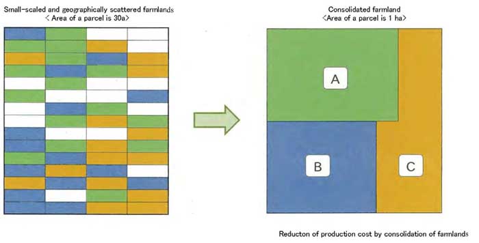
Fig. 1.
MAFF (the ministry of Agriculture, forestry and fisheries) promotes activity of Farmland Bank with various good treatment measures for lender of farmlands. One is subsidy for lender of farmlands to Farmland Bank. If farmers lease all of their farmlands except 10a to Farmland Bank for more than 10 years, they can receive from 300,000 yen (US$[3]2,655) to 700,000 yen (US$6,195) per a farmer according to size of the leased farmland. The fixed property tax is also half for 3 years or 5 years. There is also subsidy to a region from 20,000 yen (US$177) / 10a to 36,000 yen (US$319) / 10a according to ratio of farmland leased to Farmland Bank to total arable farmland. Moreover a farmer can receive 20,000 yen (177 USD)/ 10a, when the farmer leases more than two parcels of farmlands to Farmland Bank. The last measure aims to expand size of farmland in a form of lump.
This Farmland Bank system was embedded to “Personnel and Farmland Plan” just after introduction of the system, and becomes a core part for design of the Plan.
The Nationwide Navigation for Farmlands is expected to play the role of mediator between borrowers and lenders of farmlands, and promote activity of Farmland Bank. Formerly the transaction of farmlands is limited mainly in a community or municipality. However, currently the transaction area has expanded. Newcomers in agriculture and corporations to launch farming are not always from such local regions. Therefore disclosure of information about applicants of borrowers or lenders becomes indispensable. Currently the Nationwide Navigation for Farmlands does not function fully, because the information uploaded is limited in terms of area and items. However, the wider the transaction of farmlands, the more crucial the role of the Nationwide Navigation for Farmlands will be.
Scheme of Nationwide Navigation for Farmlands
1. Contents provided by the system
The system provides the following information of each parcel of farmlands.
- Name of landowner and the address
- Address, lot numbers, land category classification and area.
- Classification of the farmland by Act on Establishment of Agricultural Promotion Regions and City Planning Act.
- Intention of landowners to lease and to sell their farmland.
- Reference numbers of cultivators.
- Types of leasing right etc. and the duration.
- Acquisition of right and subleasing by Farmland Bank.
- Specification of idle farm land and implemented measures against them.
The information listed above is indicated on map (Fig. 2), which indicates the types of leasing right. The figure is original form, i.e., before translation.


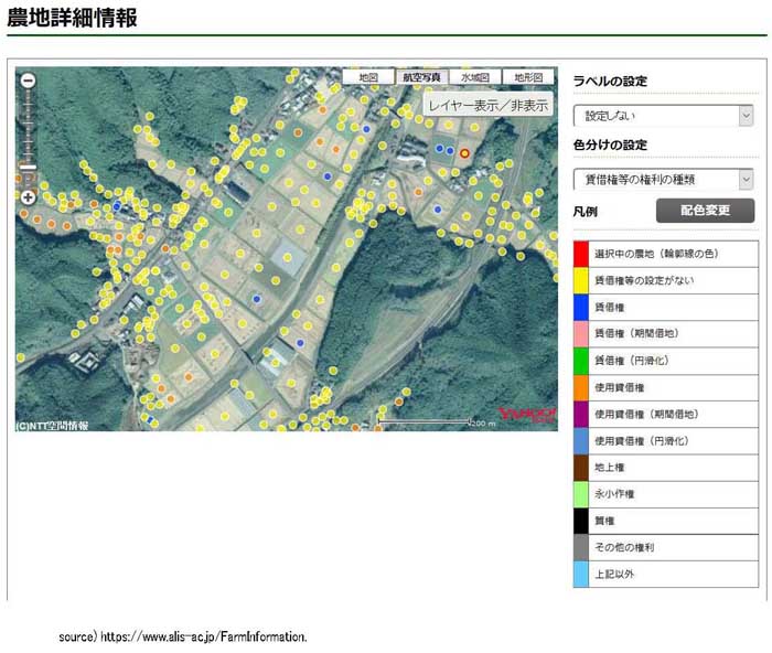
Fig. 2.
2. Users of the system and merit from the system
Users are divided into two: One is farmers who want to enlarge the size of their farmlands. The other is administrative agencies that take charge to promote consolidation of farmlands to business farmers and new entries.
Farmers who want to buy or lease land can browse and look for various information of farmlands on the web. However, they cannot browse the private information, i.e., data of name and age of the landowners, because of protection of personal data. If they want to know them, they have to visit the agricultural committee. On the other hand, administrative agencies now can browse the private information. They can know the situation of each farmland comprehensively, i.e., how the lands are consolidated to core farmers, when each lease contract will be closed, whether the land is subleased by Farmland Bank or not etc. on the website.
- Examples of using Nationwide Navigation for Farmland
Case 1: A farmer plans to enlarge the farm-size by large-size parcels in a form of lump.
In the case that a farmer plans to rent fields about three ha, which consist of large-size parcels located near his house, the farmer can browse the information of farmlands near his house, and find large-size parcels. The farmers also can identify which parcels can be subleased by the Farmland Bank.
.jpg)

Fig. 3.
Case 2: A farmer plans to rent farmlands within a year for enlargement of business size.
In cases wherem the farmer plans to rent farmland that is located near his house within a year for enlargement of business size, the farmer can identify the land meeting the conditions by classification of farmlands based on duration of leasing right.
.jpg)
Fig. 4.
Case 3: A new entrant to farming plans to rent an idle farmland for organic farming.
In cases where a new entrant wants to rent idle farmland for organic farming, which parcels are as close as possible to each other, the entrant can display only the idle land near his house and find out the land meeting his/her conditions.
.jpg)
Fig. 5.
Case 4: Administrative organs plan to share information of cultivators at a community meeting.
In cases where the administrative organs take charge of consolidation of agricultural land, i.e., municipalities and/or agricultural committees, plan to share information of cultivators with farmers at community meeting, the navigation for farmland can show who cultivates each farmland by classification of color. The web can be browsed by notebook computers or tablet PCs. Then the information can be easily shared in the meeting of community.
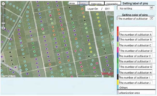
Fig. 6.
Case 5: Administrative organs plan to share information about leasing of agricultural land with farmers at community meeting.
In cases where the administrative organs plan to share information about leasing of agricultural land with farmers at community meeting, and discuss how to consolidate farmland based on data of closing date of leasing, it is possible for the organs that they indicate targeted areas of “Personal and Farmland Plan[4]”, types of leasing and the closing date of them on PC, and discuss how to consolidate farmlands.
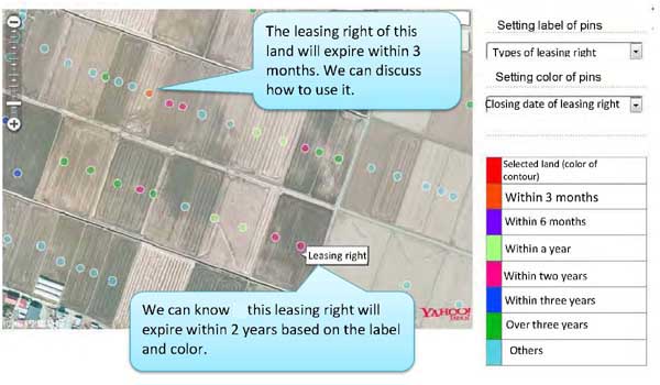
Fig. 7.
Case 6: Administrative organs plan to find potential providers of farmland for consolidation of farmland.
In cases where the organs plan to discuss how to find potential providers of farmland with each farmers and how to use farmland efficiently based on reference to situation of leasing right so on, the organs can access the farmland navigation system and indicate the situation at home of farmers for the discussion.
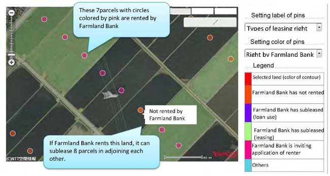
Fig. 8.
 Case 7: Administrative organs plan to sublease farmland for promotion of consolidation of farmland.
In cases where Farmland Bank examines how to sublease their land in a form of lump, the navigation system can indicate parcels of each cultivator and show how Farmland Bank can make progress in consolidation of farmland by subleasing their land.
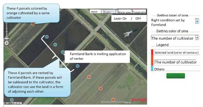
Fig. 9. 
How to use Nationwide Navigation for Farmland
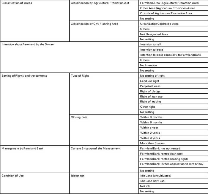
Users of the navigation system can search farmlands in two ways. One is to search by conditions that users select. The other is to search by map. In the first method, users can select the items summarized in Table 1. On the website, there are radio bottons and users can click the items that they selected. Then the navigation system displays the list of parcels that matches the conditions with corresponding data. The search is conducted all over Japan. If the users want to find the farmland regardless the location, the method is suitable. However, if users want to find appropriate farmland in some limited areas, it is efficient to search by map.
Table 1. Items for search
The research by map begins from top page of the navigation system. On the page, users can select prefecture, city-town-village and small district of each municipality (oh-aza). See Fig.10.
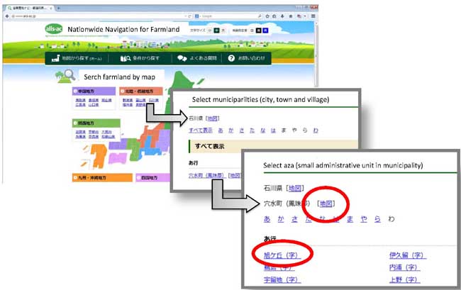

Fig. 10.
Thereafter users can find parcels that match their requirement by procedures shown from Fig. 3 to Fig. 9 so on.
[1] The items to disclose was stipulated under the article 52 by revised Agricultural Land Act. Disclosure of the information was stipulated under Article 53.
[2] The agricultural committees are established in each prefecture based on a special act, Act on agricultural committees. The main task is to control transactions (buying and selling, renting and leasing) for preservation and appropriate use of the land.
[3] The rate of Japanese Yen to USD is 113 yen per dollar.
[4] The plan is made up in a community for consolidation of farmland and transfer of it to business farmers.
|
Date submitted: Dec. 8, 2016
Reviewed, edited and uploaded: Dec. 9, 2016
|

Outline of Information Disclosure System of Farmland : Nationwide Navigation for Farmland
Introduction
The Information Disclosure System of Farmlands (the ordinary name is National wide Navigation) for Farmlands, began operation from April in 2015. The purpose of this system is to disclose information of each parcel of farmland by GIS on web site, and promote consolidation of farmlands to business farmers or new entrants to farming. National Chamber of Agriculture takes initiative to create and to operate the system. The legal base of the system is Farmlands Act revised in 2013. This report introduces background and outline of the system. URL of the website of original report is http://www.maff.go.jp/j/keiei/koukai/kikou/pdf/siryou4.pdf.
In this report the background of this system will be summarized in the next section and the report will be translated in the section 3.
Background of Nationwide Navigation for Farmlands
In December 2013 the Agricultural Land Act was revised. A new act “the Act for promotion of Farmland Bank Activities” was also enacted in the same year. The new Agricultural Land Act stipulated to disclose a part of information[1] recorded on agricultural land cadaster held by agricultural committees[2].
Corresponding to revision, a project for the development of information disclosure system of farmland began in the same year. The system worked since April in 2015. The users can browse the information on the website. In 2016, the system was renewed and data newly inputted by the agricultural committee is automatically updated on a server. Though some part of the data lacks, the data is planned to be inputted continuously.
The purpose of introducing this system is to promote consolidation of farmlands to business farmers or new entrants to farming. The consolidation of farmlands is long-standing problems in Japanese agricultural policy. Japanese government is struggling with the issue more than half of a century.
Since 2012, several new measures are introduced. First “Personnel and Farmland Plan” was introduced in 2012 by the previous ruling party, the Democratic Party of Japan. Its purpose is to make a plan about how to use farmland and who will be the cultivators through discussion in a community. Specifically the following items are focused in meetings of the community.
In 2013 two new measures were introduced by new ruling party, Japan to Liberal Democratic Party of Japan. One is Farmland Bank. The other is Outline of Information Disclosure System of Farmland, the details of which is introduced in the latter half of this report.
Farmland Bank aims to consolidate farmland to business farmers or organizations. Farmland Bank rents farmlands from farmers and subleases the farmlands to business farmers and so on in a form of lump as possible. If necessary, Farmland Bank can carry out farmland consolidation by using subsidy of the government. Outline of the function of Farmland Bank is summarized in Fig. 1.
Fig. 1.
MAFF (the ministry of Agriculture, forestry and fisheries) promotes activity of Farmland Bank with various good treatment measures for lender of farmlands. One is subsidy for lender of farmlands to Farmland Bank. If farmers lease all of their farmlands except 10a to Farmland Bank for more than 10 years, they can receive from 300,000 yen (US$[3]2,655) to 700,000 yen (US$6,195) per a farmer according to size of the leased farmland. The fixed property tax is also half for 3 years or 5 years. There is also subsidy to a region from 20,000 yen (US$177) / 10a to 36,000 yen (US$319) / 10a according to ratio of farmland leased to Farmland Bank to total arable farmland. Moreover a farmer can receive 20,000 yen (177 USD)/ 10a, when the farmer leases more than two parcels of farmlands to Farmland Bank. The last measure aims to expand size of farmland in a form of lump.
This Farmland Bank system was embedded to “Personnel and Farmland Plan” just after introduction of the system, and becomes a core part for design of the Plan.
The Nationwide Navigation for Farmlands is expected to play the role of mediator between borrowers and lenders of farmlands, and promote activity of Farmland Bank. Formerly the transaction of farmlands is limited mainly in a community or municipality. However, currently the transaction area has expanded. Newcomers in agriculture and corporations to launch farming are not always from such local regions. Therefore disclosure of information about applicants of borrowers or lenders becomes indispensable. Currently the Nationwide Navigation for Farmlands does not function fully, because the information uploaded is limited in terms of area and items. However, the wider the transaction of farmlands, the more crucial the role of the Nationwide Navigation for Farmlands will be.
Scheme of Nationwide Navigation for Farmlands
1. Contents provided by the system
The system provides the following information of each parcel of farmlands.
The information listed above is indicated on map (Fig. 2), which indicates the types of leasing right. The figure is original form, i.e., before translation.
Fig. 2.
2. Users of the system and merit from the system
Users are divided into two: One is farmers who want to enlarge the size of their farmlands. The other is administrative agencies that take charge to promote consolidation of farmlands to business farmers and new entries.
Farmers who want to buy or lease land can browse and look for various information of farmlands on the web. However, they cannot browse the private information, i.e., data of name and age of the landowners, because of protection of personal data. If they want to know them, they have to visit the agricultural committee. On the other hand, administrative agencies now can browse the private information. They can know the situation of each farmland comprehensively, i.e., how the lands are consolidated to core farmers, when each lease contract will be closed, whether the land is subleased by Farmland Bank or not etc. on the website.
Case 1: A farmer plans to enlarge the farm-size by large-size parcels in a form of lump.
In the case that a farmer plans to rent fields about three ha, which consist of large-size parcels located near his house, the farmer can browse the information of farmlands near his house, and find large-size parcels. The farmers also can identify which parcels can be subleased by the Farmland Bank.
Fig. 3.
Case 2: A farmer plans to rent farmlands within a year for enlargement of business size.
In cases wherem the farmer plans to rent farmland that is located near his house within a year for enlargement of business size, the farmer can identify the land meeting the conditions by classification of farmlands based on duration of leasing right.
Fig. 4.
Case 3: A new entrant to farming plans to rent an idle farmland for organic farming.
In cases where a new entrant wants to rent idle farmland for organic farming, which parcels are as close as possible to each other, the entrant can display only the idle land near his house and find out the land meeting his/her conditions.
Fig. 5.
Case 4: Administrative organs plan to share information of cultivators at a community meeting.
In cases where the administrative organs take charge of consolidation of agricultural land, i.e., municipalities and/or agricultural committees, plan to share information of cultivators with farmers at community meeting, the navigation for farmland can show who cultivates each farmland by classification of color. The web can be browsed by notebook computers or tablet PCs. Then the information can be easily shared in the meeting of community.
Fig. 6.
Case 5: Administrative organs plan to share information about leasing of agricultural land with farmers at community meeting.
In cases where the administrative organs plan to share information about leasing of agricultural land with farmers at community meeting, and discuss how to consolidate farmland based on data of closing date of leasing, it is possible for the organs that they indicate targeted areas of “Personal and Farmland Plan[4]”, types of leasing and the closing date of them on PC, and discuss how to consolidate farmlands.
Fig. 7.
Case 6: Administrative organs plan to find potential providers of farmland for consolidation of farmland.
In cases where the organs plan to discuss how to find potential providers of farmland with each farmers and how to use farmland efficiently based on reference to situation of leasing right so on, the organs can access the farmland navigation system and indicate the situation at home of farmers for the discussion.
Fig. 8.
In cases where Farmland Bank examines how to sublease their land in a form of lump, the navigation system can indicate parcels of each cultivator and show how Farmland Bank can make progress in consolidation of farmland by subleasing their land.
Fig. 9.
How to use Nationwide Navigation for Farmland
Users of the navigation system can search farmlands in two ways. One is to search by conditions that users select. The other is to search by map. In the first method, users can select the items summarized in Table 1. On the website, there are radio bottons and users can click the items that they selected. Then the navigation system displays the list of parcels that matches the conditions with corresponding data. The search is conducted all over Japan. If the users want to find the farmland regardless the location, the method is suitable. However, if users want to find appropriate farmland in some limited areas, it is efficient to search by map.
Table 1. Items for search
The research by map begins from top page of the navigation system. On the page, users can select prefecture, city-town-village and small district of each municipality (oh-aza). See Fig.10.
Fig. 10.
Thereafter users can find parcels that match their requirement by procedures shown from Fig. 3 to Fig. 9 so on.
[1] The items to disclose was stipulated under the article 52 by revised Agricultural Land Act. Disclosure of the information was stipulated under Article 53.
[2] The agricultural committees are established in each prefecture based on a special act, Act on agricultural committees. The main task is to control transactions (buying and selling, renting and leasing) for preservation and appropriate use of the land.
[3] The rate of Japanese Yen to USD is 113 yen per dollar.
[4] The plan is made up in a community for consolidation of farmland and transfer of it to business farmers.
Date submitted: Dec. 8, 2016
Reviewed, edited and uploaded: Dec. 9, 2016