ABSTRACT
Base on a long term project on Environmental Monitoring on Soil environment since 1996, a database on Agriculture and rural development has been developed, which including current state of agricultural production (crop production, animal husbandry, forestry and aquaculture), climate, soil environment, solid waste, biodiversity and craft village environment. The database was online on an agricultural environment website. This website was designed in structure, website elements relationships, tools for assess database, linkage of the systems, web service, database interaction, updating, and exporting and utilities. The database is firstly support for management people within agriculture sector, such as storing data, monitoring, reporting, making plan and controlling pest and diseases. Secondly, the data can be analyzed to sea the environmental trends, the abnormal events, locating the outbreaks, hot spots for environmental treatments. The data also support farmers to use data to calculate fertilizers for crops base on nutrient supply ability of the soil. The data also strongly support and share for education purpose.
Keywords: Vietnam, big data, environment, website
INTRODUCTION
There are many databases have been developed all around the world to support for people activities, from human health to natural disaster, controlling agro-products, environmental observation and monitoring. First application to mention is FAO’s database that existing as very essential tool for agricultural management and studies, such as, Agro-MAPS, AQUASTAT, FAOSTAT-Agriculture, FAOSTAT-Fisheries, and FAOSTAT-Forestry (FAO, 2014). World Resource Institute (WRI, 2019) also developed a database very early with many different languages to collect and support information about trend and changing of economic, social and environment for more than 200 countries and database are also used very usefully. Another database, Earth Trends also developed to collect data from more than 40 the world leading statistical offices with maps and database that has been analyzed by the World Resource Institute and it is evaluated as very high truthfully information resources (WRI, 2019). The database created by Maryland University and NASA can provide information on satellite images for researches on climate, water, land cover, ecosystem, mineral and environment. The supporting data includes: current data, annual reports, flood, drought, and water quality all over the world. The best practice database is one of the database holding more than 2650 solutions from more than 140 countries on social, environment and economy by 5 different languages, just to support for reducing poor, accommodation services, land business, environment protection and economic development (UN-Habitat, 2018). Alerting system developed by World Organization for Animal Health (IOE, 2008) provide guidelines for treatment of diseases by different languages that users can assess easily following the group of interest, for example, country, animal type, sources of disease and disease.
In Viet Nam, there are many databases and websites were developed assisting for agricultural sector production, such as, database of Department of animal health (Cuc Thu y, 2017) provide information of animal diseases daily at all province for controlling; Database of Viet Nam Forest (Viet Nam forest, 2017) provide information on forest area, forest production/yields and resources of plant and animal in the soil; Database developed by Department of Plant Protection (Cuc BVTV, 2017) provide all information that updated daily on crop disease and how to control; database developed by Department of Processing (Nafiqad, 2017) provides a lot of information on import export products, permission for importers exporters etc.; and more database on meteorology by National Centre for Hydro-Meteorological Forecasting (NCHMF, 2019), forest fire (Kiem Lam, 2017) and environmental alerting (Eds, 2017). Although, many databases have been developed but agricultural environment is lacking a lot of information on soil, water and environment for agricultural production, food safety production. Because of that, the objectives of work are to develop a good database on agricultural environment and develop applications for cleaner crop production and environmental protection.
METHODOLOGY
Database was developed base on the long term monitoring database since 2010 in combination with spatial data on administrative, climate, land use, soil.
The database of soil environmental built from 518 observation points over the country and characterized by different impact factors as soil erosion, erosion and leaching, salt intrusion, acid sulphate soil, waste water, industrial zone, drought, heavy fertilization. These points were observed every year since 2010. At each observation point, soil samples were taken and analyzed for physical and chemical parameters, such as concentration of soil nutrients and soil environment elements: pHH2O, pHKCl, Organic carbon, N, P2O5, K2O, Plant availability P, CEC, Ca, Mag, K, Al, Na, Cl, Cu, Pb, Zn, Cd, As, Hg, Fe, NH4, NO3, HCO3. The observed samples were taken yearly repeated at the same location with detail updated of soil, crop and farming activities every years.
Spatial data as soil map, land use map, topographic map, watershed map were collected, formatted and integrated into the database for using;
The Agricultural Environment website was developed in Visual Basic environment (VB.NET) based on the database as a core with spatial, non-spatial, temporal (from 2010 up to now) dimensions; and policy and regulation documents.
Agricultural environment reports is made for both management people and for progress reports by filtering the data from interest areas and time periods with analysis results to compare analyzed parameters with standard levels, the trend of each parameter in time. Sharing functions also developed to provide data for interested people with educational purposes.
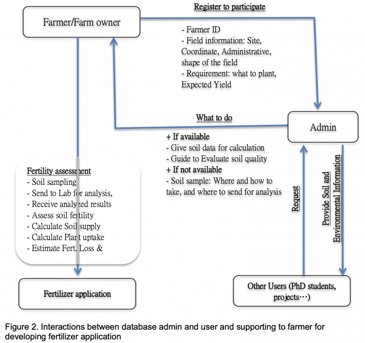
Applications: From available soil data, we used the QUEFTS model (QUantitative Evaluation of the Fertility of Tropical Soils - Janssen et al., 1990; Ingrid, 2000), to predict crop yields from chemical soil characteristics, as an indicator of soil fertility. We then compare these predictions with actual yields as well as fertility estimated by farmers. From theory, we went further to developed a decision support tool to help farmer to explore their own fields fertility and calculate fertilizer level based on soil supply capacity and meet plant needs, as described in the figure 2.
The model has been implemented on 10 farmer fields to grow maize with input parameters of: Acidity or pH (HO), Organic Carbon (org.C.), P-Olsen, and Exchangeable potassium (exch.K). Additionally, for alternative specifications are: Organic nitrogen (org.N), Total P, Temperature (C), Clay content (clay %)
Maize yield and Fertilizer for maize was calculated following the model principle with 4 steps. Step 1 to calculate Supply of nitrogen (SN), phosphorus (SP) and potassium (SK) in the soil; Step 2 to determine Actual uptake of nitrogen (UN), phosphorus (UP) and potassium (UK); Step 3 to determine Yield maximally Diluted for by Nitrogen (YND), by phosphorus (YPD) and potassium (YKD) and the lower bound yield refers to the Yield maximally Accumulated by nitrogen (YNA), phosphorus (YPA) and potassium (YKA); and step 4 to calculate final yield from comparing all above yields to have average. From soil nutrient supply and actual nutrient uptake, we can estimate total amount of fertilizer to recommend the farmer to apply for target maize yields. Therefore, the practical maize yields are expected to approach the estimated one using this model.
RESULTS AND DICUSSION
Database
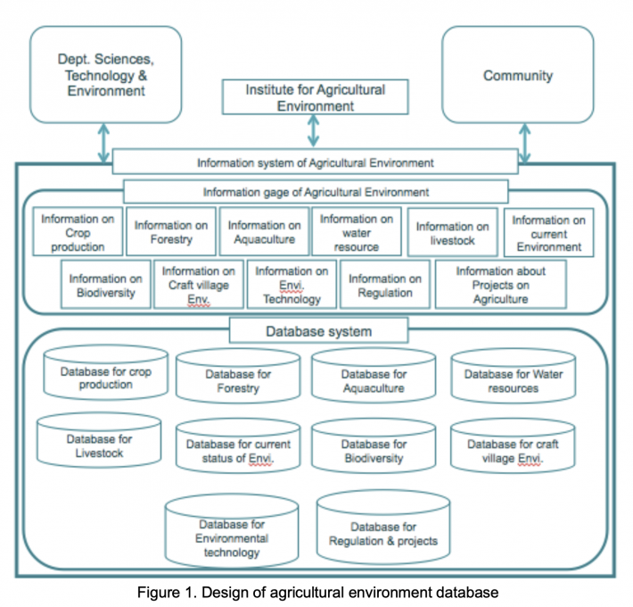
A database was developed with different data, such as General information (about spatial and temporal data, maps or observation points…); data on agricultural production includes crop production with information of all crops, livestock, aquaculture, forestry, water resources for irrigation systems, craft villages at 63 provinces; data on environment observation with an observation network of soil, water (for irrigation purpose), aquaculture, and craft village since 2010 up to now. All data were presented on maps together with base maps of topography, soil, land use, climate.
Website of agriculture Environment data
The database is a core of the agriculture environment website (Figure 3) or website is the one presenting all database attributes.
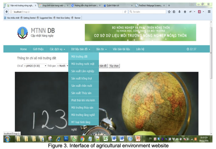
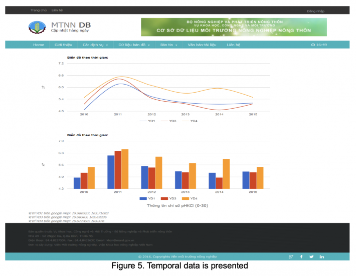
The website is designed with different modules (Figure 3). The core module stores all database of agricultural production, observation network with data that can be presented on maps (Figure 4). From this module, we can have different view of data in detail at single parameter, e.g. soil pH, soil organics carbon, nitrogen, or Cadmium… in time series to see the trend of those environmental parameters. User can also search for what data they need and se how the data look like before they ask for sharing (Figure 5). The module also can help management people to filter for making reports on current agricultural environment in interested regions/points.
On besides, the website has another module to store policy documents and technologies to treat environment and cleaner production that can be references for all interested people.

User and applications
The website counted an increasing number of visitor that most people related to scientific, who are MSc, PhD student and scientific doing project looking for data of soil, water, and environmental data. The visitors are also farm owners and progressive farmer, who really dedicate in deep investment of their farms to have either high yield, income or optimize their production with least investment and loss.
Application of QUEFTS model to support farmer on cultivating maize
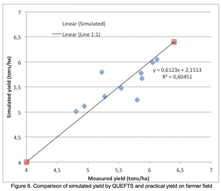
Data shows a relatively good correlation between estimated soil nutrient supply, recommended fertilizer, maize yields and measurement one. The application may be improved in both methodology and approaching, but it allows us to confidently approve to the farmer about the science fertilizer recommendations and benefits of following scientific calculation and recommendation from scientific. We have used farmer fields, which implemented the guideline of calculating soil supply and recommended fertilizer for visiting and training points with larger number of both inside and outside project. This helps to convincing people to believe and increasing number of farmer to participate in adapting model in the future.
CONCLUSIONS
According to project results we can draw some conclusions as in the follow: More and more scientific and farmer pay attention on using research results, scientific data as well as attracting to use and share data in agricultural production and environmental prediction; The agricultural environment database is very useful for both doing research and applying to practice production as well as environmental prediction; Results from application supporting model to the farmer showed very highly necessary to transfer technologies to the farmer or to fill the gaps between scientific and end user to optimize production and minimize environmental pollution.
REFERENCES
BVTV, 2017, Database and website of Department of Plant Protection, Ministry of Agriculture and Rural Development
Cuc Thu y, 2017, Database and website of Department of Animal Health
Eds, 2017, Database and website for alerting aquaculture diseases
FAO, 2014. FAO’s data source, http://www.fao.org/countryprofiles/data-sources/en/
Ingrid, M., 2000, Soil Fertility: QUEFTS and Farmers’ Perceptions, CREED Working Paper Series No 30
IOE, 2008, Database and website of World Organization for Animal Health
Janssen, B.H., Guiking, F.C.T., Van der Eijk, D., Smaling, E.M.A., Wolf, J. and Van Reuler, H. 1990. ‘A system for quantitative evaluation of the fertility of tropical soils QUEFTS.’ Geoderma 46: 299-318.
Kiem Lam, 2017, Database and website of VNforest, Ministry of Agriculture and Rural Development;
Nafiqad, 2017, Database and website of Department of Agro-processing, Ministry of Agriculture and Rural Development
NCHMF, 2017, National Centre for Hydro-Meteorological Forecasting database and website (http://www.nchmf.gov.vn/web/en-US/105/92/Default.aspx)
UN-Habitat, 2019, Database and website of UN-HABITAT, https://www.un.org/ruleoflaw/un-and-the- rule-of-law/united-nations-human-settlements-programme/
WRI, 2019, Database and website of World Resource Institute, https://www.wri.org
Date submitted: October 29, 2019
Reviewed, edited and uploaded: November 29, 2019 |

Developing an Environmental Database for Agriculture and Rural Development in Vietnam
ABSTRACT
Base on a long term project on Environmental Monitoring on Soil environment since 1996, a database on Agriculture and rural development has been developed, which including current state of agricultural production (crop production, animal husbandry, forestry and aquaculture), climate, soil environment, solid waste, biodiversity and craft village environment. The database was online on an agricultural environment website. This website was designed in structure, website elements relationships, tools for assess database, linkage of the systems, web service, database interaction, updating, and exporting and utilities. The database is firstly support for management people within agriculture sector, such as storing data, monitoring, reporting, making plan and controlling pest and diseases. Secondly, the data can be analyzed to sea the environmental trends, the abnormal events, locating the outbreaks, hot spots for environmental treatments. The data also support farmers to use data to calculate fertilizers for crops base on nutrient supply ability of the soil. The data also strongly support and share for education purpose.
Keywords: Vietnam, big data, environment, website
INTRODUCTION
There are many databases have been developed all around the world to support for people activities, from human health to natural disaster, controlling agro-products, environmental observation and monitoring. First application to mention is FAO’s database that existing as very essential tool for agricultural management and studies, such as, Agro-MAPS, AQUASTAT, FAOSTAT-Agriculture, FAOSTAT-Fisheries, and FAOSTAT-Forestry (FAO, 2014). World Resource Institute (WRI, 2019) also developed a database very early with many different languages to collect and support information about trend and changing of economic, social and environment for more than 200 countries and database are also used very usefully. Another database, Earth Trends also developed to collect data from more than 40 the world leading statistical offices with maps and database that has been analyzed by the World Resource Institute and it is evaluated as very high truthfully information resources (WRI, 2019). The database created by Maryland University and NASA can provide information on satellite images for researches on climate, water, land cover, ecosystem, mineral and environment. The supporting data includes: current data, annual reports, flood, drought, and water quality all over the world. The best practice database is one of the database holding more than 2650 solutions from more than 140 countries on social, environment and economy by 5 different languages, just to support for reducing poor, accommodation services, land business, environment protection and economic development (UN-Habitat, 2018). Alerting system developed by World Organization for Animal Health (IOE, 2008) provide guidelines for treatment of diseases by different languages that users can assess easily following the group of interest, for example, country, animal type, sources of disease and disease.
In Viet Nam, there are many databases and websites were developed assisting for agricultural sector production, such as, database of Department of animal health (Cuc Thu y, 2017) provide information of animal diseases daily at all province for controlling; Database of Viet Nam Forest (Viet Nam forest, 2017) provide information on forest area, forest production/yields and resources of plant and animal in the soil; Database developed by Department of Plant Protection (Cuc BVTV, 2017) provide all information that updated daily on crop disease and how to control; database developed by Department of Processing (Nafiqad, 2017) provides a lot of information on import export products, permission for importers exporters etc.; and more database on meteorology by National Centre for Hydro-Meteorological Forecasting (NCHMF, 2019), forest fire (Kiem Lam, 2017) and environmental alerting (Eds, 2017). Although, many databases have been developed but agricultural environment is lacking a lot of information on soil, water and environment for agricultural production, food safety production. Because of that, the objectives of work are to develop a good database on agricultural environment and develop applications for cleaner crop production and environmental protection.
METHODOLOGY
Database was developed base on the long term monitoring database since 2010 in combination with spatial data on administrative, climate, land use, soil.
The database of soil environmental built from 518 observation points over the country and characterized by different impact factors as soil erosion, erosion and leaching, salt intrusion, acid sulphate soil, waste water, industrial zone, drought, heavy fertilization. These points were observed every year since 2010. At each observation point, soil samples were taken and analyzed for physical and chemical parameters, such as concentration of soil nutrients and soil environment elements: pHH2O, pHKCl, Organic carbon, N, P2O5, K2O, Plant availability P, CEC, Ca, Mag, K, Al, Na, Cl, Cu, Pb, Zn, Cd, As, Hg, Fe, NH4, NO3, HCO3. The observed samples were taken yearly repeated at the same location with detail updated of soil, crop and farming activities every years.
Spatial data as soil map, land use map, topographic map, watershed map were collected, formatted and integrated into the database for using;
The Agricultural Environment website was developed in Visual Basic environment (VB.NET) based on the database as a core with spatial, non-spatial, temporal (from 2010 up to now) dimensions; and policy and regulation documents.
Agricultural environment reports is made for both management people and for progress reports by filtering the data from interest areas and time periods with analysis results to compare analyzed parameters with standard levels, the trend of each parameter in time. Sharing functions also developed to provide data for interested people with educational purposes.
Applications: From available soil data, we used the QUEFTS model (QUantitative Evaluation of the Fertility of Tropical Soils - Janssen et al., 1990; Ingrid, 2000), to predict crop yields from chemical soil characteristics, as an indicator of soil fertility. We then compare these predictions with actual yields as well as fertility estimated by farmers. From theory, we went further to developed a decision support tool to help farmer to explore their own fields fertility and calculate fertilizer level based on soil supply capacity and meet plant needs, as described in the figure 2.
The model has been implemented on 10 farmer fields to grow maize with input parameters of: Acidity or pH (HO), Organic Carbon (org.C.), P-Olsen, and Exchangeable potassium (exch.K). Additionally, for alternative specifications are: Organic nitrogen (org.N), Total P, Temperature (C), Clay content (clay %)
Maize yield and Fertilizer for maize was calculated following the model principle with 4 steps. Step 1 to calculate Supply of nitrogen (SN), phosphorus (SP) and potassium (SK) in the soil; Step 2 to determine Actual uptake of nitrogen (UN), phosphorus (UP) and potassium (UK); Step 3 to determine Yield maximally Diluted for by Nitrogen (YND), by phosphorus (YPD) and potassium (YKD) and the lower bound yield refers to the Yield maximally Accumulated by nitrogen (YNA), phosphorus (YPA) and potassium (YKA); and step 4 to calculate final yield from comparing all above yields to have average. From soil nutrient supply and actual nutrient uptake, we can estimate total amount of fertilizer to recommend the farmer to apply for target maize yields. Therefore, the practical maize yields are expected to approach the estimated one using this model.
RESULTS AND DICUSSION
Database
A database was developed with different data, such as General information (about spatial and temporal data, maps or observation points…); data on agricultural production includes crop production with information of all crops, livestock, aquaculture, forestry, water resources for irrigation systems, craft villages at 63 provinces; data on environment observation with an observation network of soil, water (for irrigation purpose), aquaculture, and craft village since 2010 up to now. All data were presented on maps together with base maps of topography, soil, land use, climate.
Website of agriculture Environment data
The database is a core of the agriculture environment website (Figure 3) or website is the one presenting all database attributes.
The website is designed with different modules (Figure 3). The core module stores all database of agricultural production, observation network with data that can be presented on maps (Figure 4). From this module, we can have different view of data in detail at single parameter, e.g. soil pH, soil organics carbon, nitrogen, or Cadmium… in time series to see the trend of those environmental parameters. User can also search for what data they need and se how the data look like before they ask for sharing (Figure 5). The module also can help management people to filter for making reports on current agricultural environment in interested regions/points.
On besides, the website has another module to store policy documents and technologies to treat environment and cleaner production that can be references for all interested people.
User and applications
The website counted an increasing number of visitor that most people related to scientific, who are MSc, PhD student and scientific doing project looking for data of soil, water, and environmental data. The visitors are also farm owners and progressive farmer, who really dedicate in deep investment of their farms to have either high yield, income or optimize their production with least investment and loss.
Application of QUEFTS model to support farmer on cultivating maize
Data shows a relatively good correlation between estimated soil nutrient supply, recommended fertilizer, maize yields and measurement one. The application may be improved in both methodology and approaching, but it allows us to confidently approve to the farmer about the science fertilizer recommendations and benefits of following scientific calculation and recommendation from scientific. We have used farmer fields, which implemented the guideline of calculating soil supply and recommended fertilizer for visiting and training points with larger number of both inside and outside project. This helps to convincing people to believe and increasing number of farmer to participate in adapting model in the future.
CONCLUSIONS
According to project results we can draw some conclusions as in the follow: More and more scientific and farmer pay attention on using research results, scientific data as well as attracting to use and share data in agricultural production and environmental prediction; The agricultural environment database is very useful for both doing research and applying to practice production as well as environmental prediction; Results from application supporting model to the farmer showed very highly necessary to transfer technologies to the farmer or to fill the gaps between scientific and end user to optimize production and minimize environmental pollution.
REFERENCES
BVTV, 2017, Database and website of Department of Plant Protection, Ministry of Agriculture and Rural Development
Cuc Thu y, 2017, Database and website of Department of Animal Health
Eds, 2017, Database and website for alerting aquaculture diseases
FAO, 2014. FAO’s data source, http://www.fao.org/countryprofiles/data-sources/en/
Ingrid, M., 2000, Soil Fertility: QUEFTS and Farmers’ Perceptions, CREED Working Paper Series No 30
IOE, 2008, Database and website of World Organization for Animal Health
Janssen, B.H., Guiking, F.C.T., Van der Eijk, D., Smaling, E.M.A., Wolf, J. and Van Reuler, H. 1990. ‘A system for quantitative evaluation of the fertility of tropical soils QUEFTS.’ Geoderma 46: 299-318.
Kiem Lam, 2017, Database and website of VNforest, Ministry of Agriculture and Rural Development;
Nafiqad, 2017, Database and website of Department of Agro-processing, Ministry of Agriculture and Rural Development
NCHMF, 2017, National Centre for Hydro-Meteorological Forecasting database and website (http://www.nchmf.gov.vn/web/en-US/105/92/Default.aspx)
UN-Habitat, 2019, Database and website of UN-HABITAT, https://www.un.org/ruleoflaw/un-and-the- rule-of-law/united-nations-human-settlements-programme/
WRI, 2019, Database and website of World Resource Institute, https://www.wri.org
Reviewed, edited and uploaded: November 29, 2019